We’ve reached Sept. 24th, the date after which it is quite rare for Texas to get struck by a hurricane. And as we’ll discuss below, with a few caveats, we expect that Texas is done with hurricanes this year as well. But first, let’s get to a wet forecast.
Monday
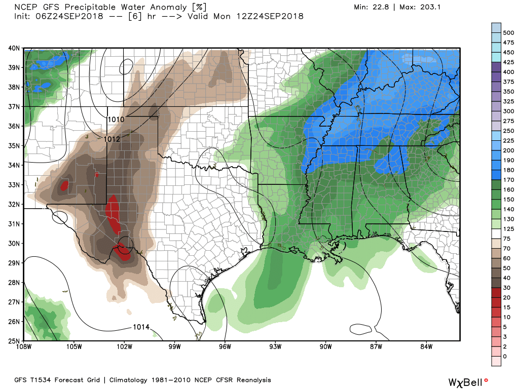
After Saturday night’s surprising cold front passage, Houston enjoyed drier conditions on Sunday, and that should be the case today as well as most of the moisture remains to the east of the region, off the coast and over Louisiana.
Greater moisture levels (precipitable water) are east of the Houston region on Monday. (Weather Bell)
As a result, we can probably expect partly sunny skies today, with high temperatures near 90 degrees, and only some isolated showers and thunderstorms this afternoon. The (slightly) drier air ushered into the region by Saturday’s weak front will probably hang around through most of day and this evening before being washed away by returning Gulf of Mexico moisture.
Tuesday
Gulf moisture should begin returning Monday night and Tuesday, and while this won’t have too much of an effect on temperatures, we should see rain chances creep back up to the 30 to 40 percent range, with a corresponding increase in humidity.
A weak, dying cold front pushed through the Houston area on Saturday night—if you were awoken by storms, that was it—and this will set the stage for a couple of drier days. Initially, we expected this front to stall out near or over Houston, leading to more wet weather, but as it has pushed far enough east most areas should see a bit of a reprieve for a few days from the rain.
Low temperatures on Sunday morning are nice, especially to the west where the front made it. (National Weather Service)
Temperature wise it won’t make too much of a difference, with highs still near around 90 degrees on Sunday and Monday with partly sunny skies, but mornings and evenings should feel a bit more pleasant until the front slides back tomorrow some time.
After this we’ll fall back into a wet pattern beginning later on Tuesday or Wednesday as another front nears the area. Again, we expect this one to stall before or near Houston, leaving us in a muggy, wet pattern. But if we get lucky again, perhaps that front will push through Houston as well, making for nicer weather next weekend. I certainly wouldn’t bet on it at this point, so for now just enjoy what should be a pretty nice Sunday.
After a few days off, unsettled weather returned on Thursday, bringing some folks over three inches of rain. Others saw nothing at all, but everyone is likely in line to see at least some rain over the next couple days.
Today
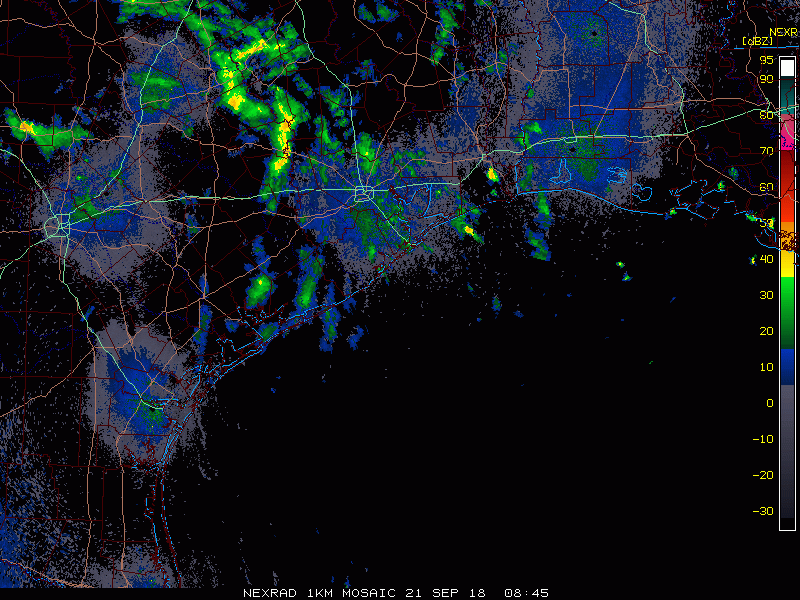
Radar isn’t too active this morning with a few scattered showers — mostly light or occasionally moderate rain.
Radar shows a smattering of showers or lighter rains across the area this morning. (College of DuPage)
As we go into the rest of today, look for scattered downpours and thunderstorms to blossom from later this morning into this afternoon. Like yesterday, we could see locally heavy rainfall in the most persistent storms. Rain amounts will again vary wildly, with some folks seeing little to no rain, while others could see two to four inches in a relatively short time, along with some localized street flooding.
Saturday & Sunday
Unfortunately, the specifics surrounding the forecast this weekend are going to be difficult to lay out. If you’ve lived in Southeast Texas for any length of time, you know that our rain often follows a pattern of feast or famine: Neighborhoods that get soaked may be adjacent to dry neighborhoods. Trying to predict where and when it’s going to rain this weekend is impossible to do more than a few hours in advance, but we know that both Saturday and Sunday carry high chances that it will rain for a period of time during the morning or afternoon hours.
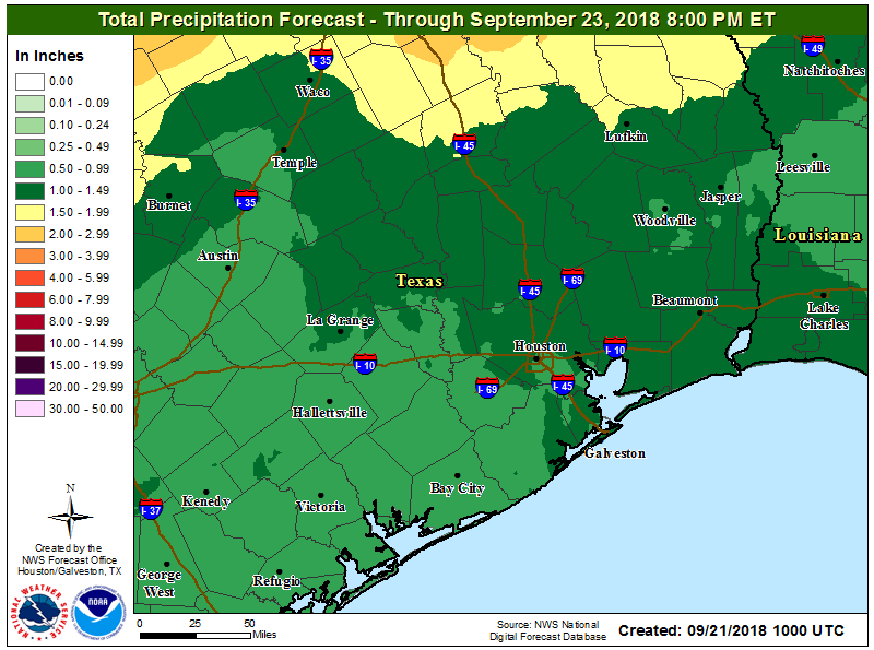
Specific rain amounts will vary significantly from place to place through Sunday evening. On average, expect an inch or two, with some places seeing more and others less. (NWS)
Total rainfall should add up to about an inch to two inches on average across the region by Sunday evening. Some folks will see less than that. Others may see three, four, or five inches of rain or even a little more with some street flooding. If you have outdoor plans this weekend, include an umbrella and an indoor backup if possible. Where the heaviest ultimately falls will depend on how far south a cold front can push, along with other small-scale processes in the atmosphere.
If there’s good news in all this, it’s that our six day string of 90°+ weather should end. We’ll see high temperatures in the mid-80s, with lows in the mid-70s. Yes, it will be unpleasantly humid, but at least it won’t be obscenely hot for later September.
After five dry days for most of the Houston region, we will now transition back into a wetter pattern for the next week or so as high pressure moves out of the area. After today, rain chances will likely be 50 percent or higher each day for the next week, although as of now there are no indications of any particularly widespread, heavy rainfall that will lead to significant flooding problems.
Thursday
Some showers will return today, particularly to the west and southwest of the Houston area. However, I expect most of the area to at least see some partly sunny skies, which will allow for high temperatures to get up about 90 degrees. We’ll probably see the most sunshine today that we’re going to see until at least Tuesday or Wednesday of next week.
Friday, Saturday, and Sunday
Unfortunately, we can probably expect to see fairly widespread showers and thunderstorms this weekend. Again, we don’t anticipate a washout, but rain probably will never be too far away in terms of timing and distance, and some intermittently heavy rainfall is possible. Skies should be mostly cloudy, with high temperatures likely between 85 and 90 degrees.
NOAA rain accumulation forecast for now through next Wednesday. (Pivotal Weather)
Everyone will want to know how much rainfall is coming, and that is something that is really hard to predict. For example, during the first two weeks of this month the area received wildly variable rainfall amounts from 2 to 20 inches. With the showers and storms this weekend, we can probably generally expect 1 to 3 inches of rain, with some isolated higher totals in the 4 to 6 inch range. Where will these higher totals be? If I had to guess it would be west or southwest of Houston, but overall confidence is fairly low.