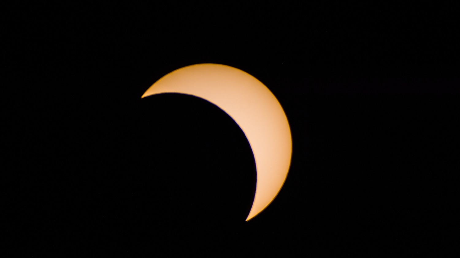
Houston enjoyed reasonably good weather for the partial eclipse on Monday, and perhaps what was most striking to me is how pleasant it felt outside shortly after 1pm, when about two-thirds of the Sun was obscured by the Moon. If only every August afternoon felt like that. In any case, it is now time for us to focus on the weather, with the potential for a very wet weekend due to tropical moisture.
Photo taken of the eclipse maximum, from Friendswood, with Celestron 8″ telescope. (Darrell Lee)
Tuesday through Thursday
Houston will remain in a summer-like pattern for most of the rest of the work week—with highs in the low- to mid-90s and scattered afternoon showers—with a few twists. Most notably, a cool front will sag into the northern parts of the Houston region by late Wednesday or so, and while this won’t provide much relief from the heat it could raise rain chances a little bit.
After very hot and dull weather for the last week or 10 days, our region will see more dynamic conditions during the week ahead as the high pressure system breaks down. This will lead to generally better rain chances and slightly cooler weather.
Today
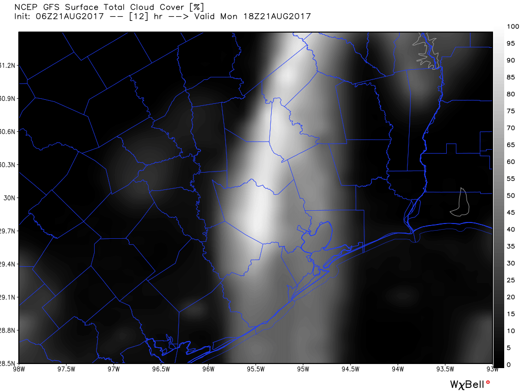
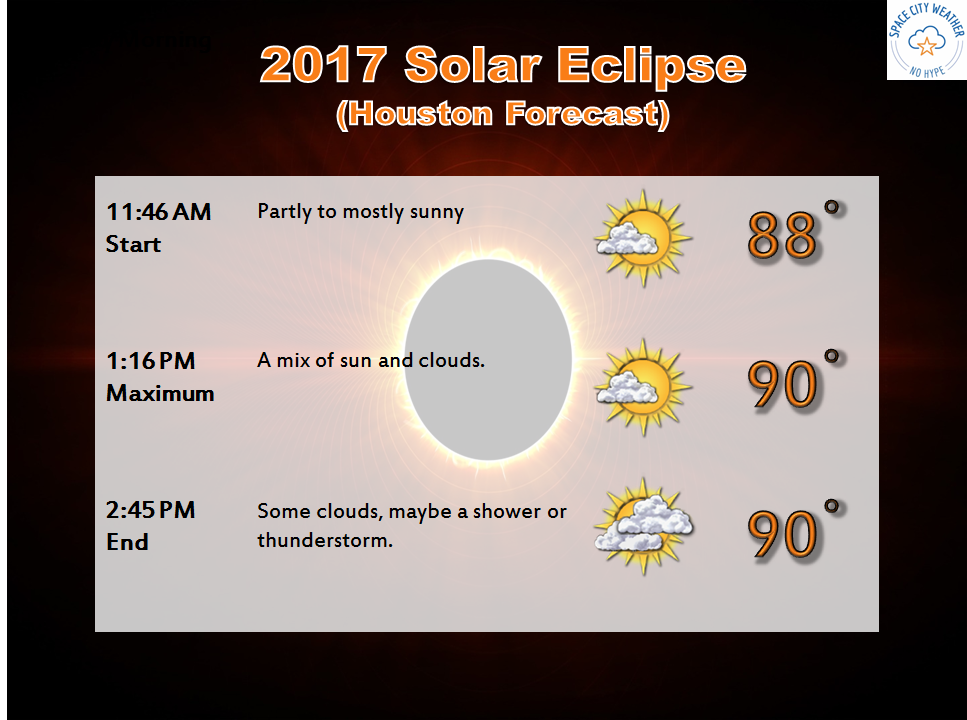
As most everyone knows, a total solar eclipse will cross the United States today, in a line from Oregon through South Carolina. The Houston area will see about 70 percent of the Sun obscured by the Moon (do not directly look at the Sun), with the maximum coverage at 1:16pm CT. We are going to have to be concerned about clouds today, but for the most part they should be broken enough to see the phenomenon at times (the partial eclipse begins at 11:46am CT and runs through 2:45pm). I’d expect 40 to 60 percent sky cover for most of the area shortly after noon today.
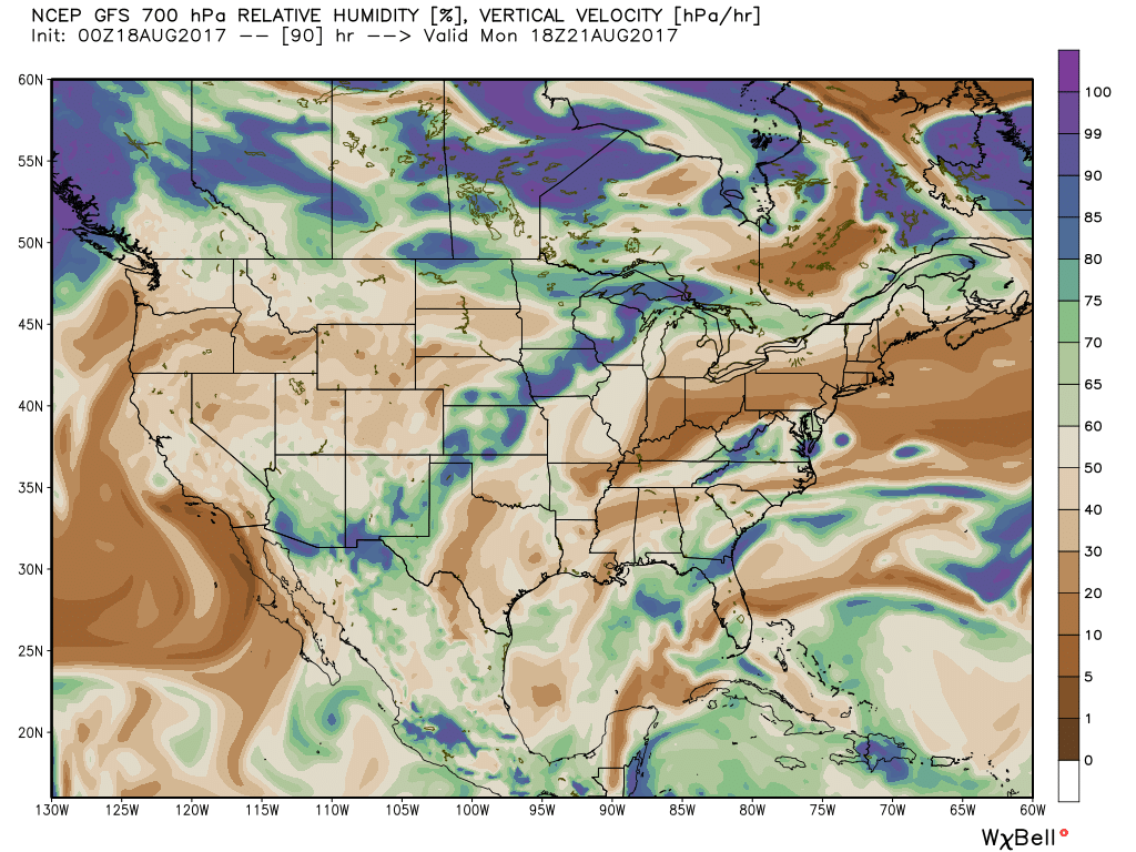
GFS model for cloud cover at noon CT today. Whiter means more cloudy. (Weather Bell)
The region will also see some scattered showers and thunderstorms this afternoon as pressures fall and atmospheric moisture levels rise, which could be hitting around the time kids are coming home from the first day of school. Where it doesn’t rain, look for highs in the low- to mid-90s.
Tuesday and Wednesday
These will be typical summertime days in Houston, as there will be no major forcing events for our weather. With slightly lower pressures, look for highs in the mid-90s, with partly sunny skies, and about a 30 percent chance of showers and thunderstorms during the afternoon and early evening hours.
Lots to get to today, including Monday’s eclipse and the tropics. But first, we have some breaking news: August in Houston is brutal. It continues in 2017 like almost every other August. Our last 5 days have seen high temperatures of 97°, 96°, 97°, 96°, and 97°. By that metric, today should see a high temperature of 96°, right? Potentially. These temperatures, while blistering hot, aren’t a whole lot hotter than normal. But when combined with the humidity, it’s felt pretty terrible. This will mostly continue.
Today & Weekend
Lather, rinse, repeat. This forecast should be pretty straightforward. Expect sunshine and hot, humid weather. High temperatures will top off in the mid or upper 90s. We’re running just a little cooler this morning than we have seen lately, so perhaps we can avoid more Heat Advisories today or tomorrow. Regardless of whether we do or not, take it easy outdoors. An isolated downpour is entirely possible on any given afternoon in one or two spots. The best chance for this would probably be on Sunday.
Monday & Eclipse
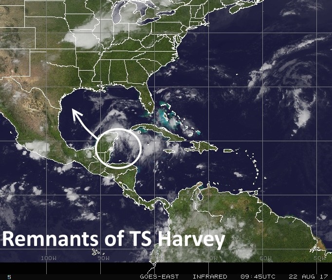
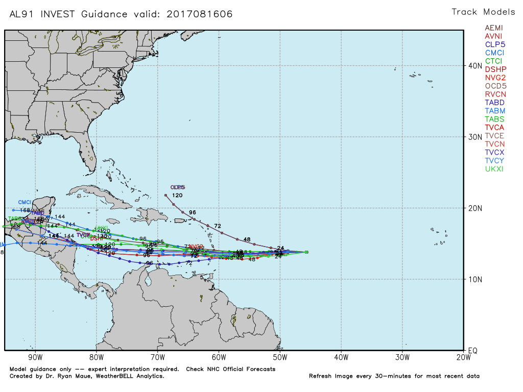
The more I watch Monday’s forecast the more I get a little uneasy. Now, I still think the vast majority of the region will have a fine opportunity to view our partial eclipse. But I’m watching a tropical wave and upper level low moving across the Gulf early next week. The timing of the arrival of the leading edge of this disturbance is Monday afternoon. Models insist the best available moisture for the most clouds will remain out over the Gulf to our east. That’s encouraging. So for now, we’re going to continue to spin the forecast optimistically. Yes, a chance of a downpour or thunderstorm will exist in the area, especially south and east of Houston by eclipse time. But I suspect we aren’t going to see too many serious clouds. So, I feel optimistic, but we’ll be watching the evolution of this forecast closely through the weekend.
(Space City Weather)
Elsewhere across East Texas, other than passing cumulus clouds, it looks pretty good. For those of you traveling to another state, here’s an update:
Green and purple on this map indicates the best chance for clouds and/or showers during the eclipse. (Weather Bell)
Washington, Oregon, and Idaho may see some low clouds or haze issues in spots, but Wyoming and western Nebraska look good. Eastern Nebraska into northwest Missouri has the best shot at cloud cover it appears. Conditions should improve near the peak eclipse spots of southern Illinois and Kentucky. A few showers may be possible in the Southeast, but I suspect they’ll be hit or miss.
Summer continues, with not a whole lot of change in the forecast through the weekend. As has been the case for much of the week, a moderately strong ridge of high pressure will continue to assert some control over our weather to bring August-like conditions to the area.
Thursday through Sunday
You know the drill by now—partly to mostly sunny days, high temperatures in the mid- to upper-90s with humidity, and lows in the upper 70s. A few (very few, most likely) areas will see some showers during the late morning and afternoon hours, but for the most part we should be dry. This is classic August weather for Houston.
Monday and Tuesday
By late Sunday or Monday, an upper-level low pressure system will begin to influence our weather as well, which should bring some changes. Most notably, we’ll see a few more clouds (we discuss eclipse concerns below), some better rain chances, and lower high temperatures, perhaps in the low 90s. By no means are we looking at widespread, heavy rainfall, but 30 to 40 percent of the region should see a couple of tenths of an inch of rainfall on both days. Highs should jump back up into the mid-90s by the second half of next week.