Houston had three consecutive days of 80-degree temperatures at the end of last week—the first time that has happened since mid-November. These warmer temperatures, generally in the upper 70s to 80 degrees are going to hang around this week, too. The other big story will be rainfall, with a couple of inches likely this week as moisture levels surge upward.
Monday
Today should be pretty nice, all things considered, and may be the best day of the week. We should see partly sunny skies, with only a slight chance of rain as high temperatures rise to about 80 degrees. The only concern is building southerly winds, which could make for a fairly gusty afternoon. These winds, and the moisture they bring, will be a harbinger for the rest of the week.
Tuesday and Wednesday
The primary dynamic beginning Tuesday will be increasing rain chances as a series of disturbances move into Texas from Mexico at the same time a slowly moving cold front moves toward the area and stalls. For now it appears the best rain chances will be north and northeast of Houston (certainly some flooding is possible for the areas facing 6 inches or more in the map below).
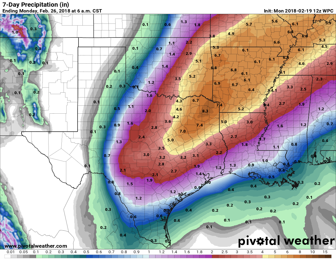
Rain chances appear to be highest from Tuesday night through Wednesday night, and I’d expect most of the Houston region to receive 1.5 to 2.5 inches, with higher amounts where heavy storms establish themselves. We’ll have to watch for the potential of street flooding. High temperatures will be in the upper 70s with warm nights.

Thursday
The better rain chances should come to an end on Thursday, although likely some scattered showers will persist. Temperatures will be dependent upon how far the cool front pushes before stalling and lifting back north. I don’t expect the front to push all the way through Houston, so I’d expect most of the region to remain in the 70s, with relatively warm nights. (Hey, we weren’t kidding last week when we told you winter was over).
Friday, Saturday, and Sunday
Stop me if you’ve heard this before. But unfortunately, we are looking at another mostly cloudy weekend ahead, with at least a few showers possible due to the onshore flow. (This forecast will have to be refined as we get closer). Houston can probably expect highs in the upper 70s before some kind of cold front pushes into the area on Sunday-ish. This should remove some of the humidity, although it’s not clear how much colder we’ll get early next week.
Is it just me or is this year very similar to 2011? It was super cold in February until Valentine’s Day and then pivoted and got really warm. I hope the rest of the year follows a different plan than that year!!
Eeek. I hope it’s not too similar. Wasn’t that the terrible drought year when tons of trees died?
Thank you for a very nice and detailed weather report. This sure ain’t southern Cali weather 😁
So do you think we’re done with freezing temps? Time to ready the vegetable garden?
How will this rain affect the level of drought in the state?
Sigh…. I was reflecting today that if we at least if we had a hockey team, I could go to a game and pretend it was still winter. Unfortunately, thanks to Le$ Alexander, we no longer have one…. double sigh.
I would be so into a local hockey team.