The heat goes on for Houston

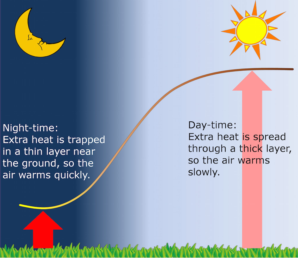
Houston’s scorching stretch of weather continues. This is certainly not unusual for early July, but the nighttime temperatures certainly have been in a league of minimal, elite company. Eric discussed this yesterday afternoon. In a touch of good news, the temperature dropped below 80° around 4 AM for the first time since last Saturday.

Assuming our low is indeed 79° this morning, the last 6 days of low temperatures averaged 81.2°, it would be the warmest 6 day stretch of nighttimes in Houston’s recorded history (going back to the late 1800s).

Houston's warmest 6 day stretch of minimum temperatures prior to this morning. (Midwest Regional Climate Center)
Houston’s warmest 6 day stretches of minimum temperatures prior to this morning. (Midwest Regional Climate Center)

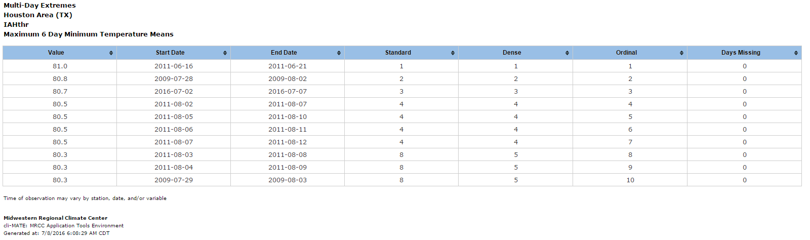
Even if it’s “only” 78° this morning, it will tie 2011 at 81.0°. We’ll see later. It’s all statistics and knit picking at this point anyway: It has been uncomfortably hot, and more of the same is on the way.

TODAY THROUGH SUNDAY

Sunny, hot conditions will continue mostly unabated through the weekend. That being said, even yesterday we saw a handful of showers east of Houston in the late morning. As we go through the next few days, yes, there could be some showers around. Those will be extremely hit/miss, and you should probably consider yourself lucky if you end up under one. High temperatures will hit the mid 90s away from the coast without much trouble. Low temperatures will only bottom out around 80°, give or take a couple degrees, in most spots.

Traveling this weekend? Your travel forecast is below:

Travel forecast for the weekend of July 8-10.

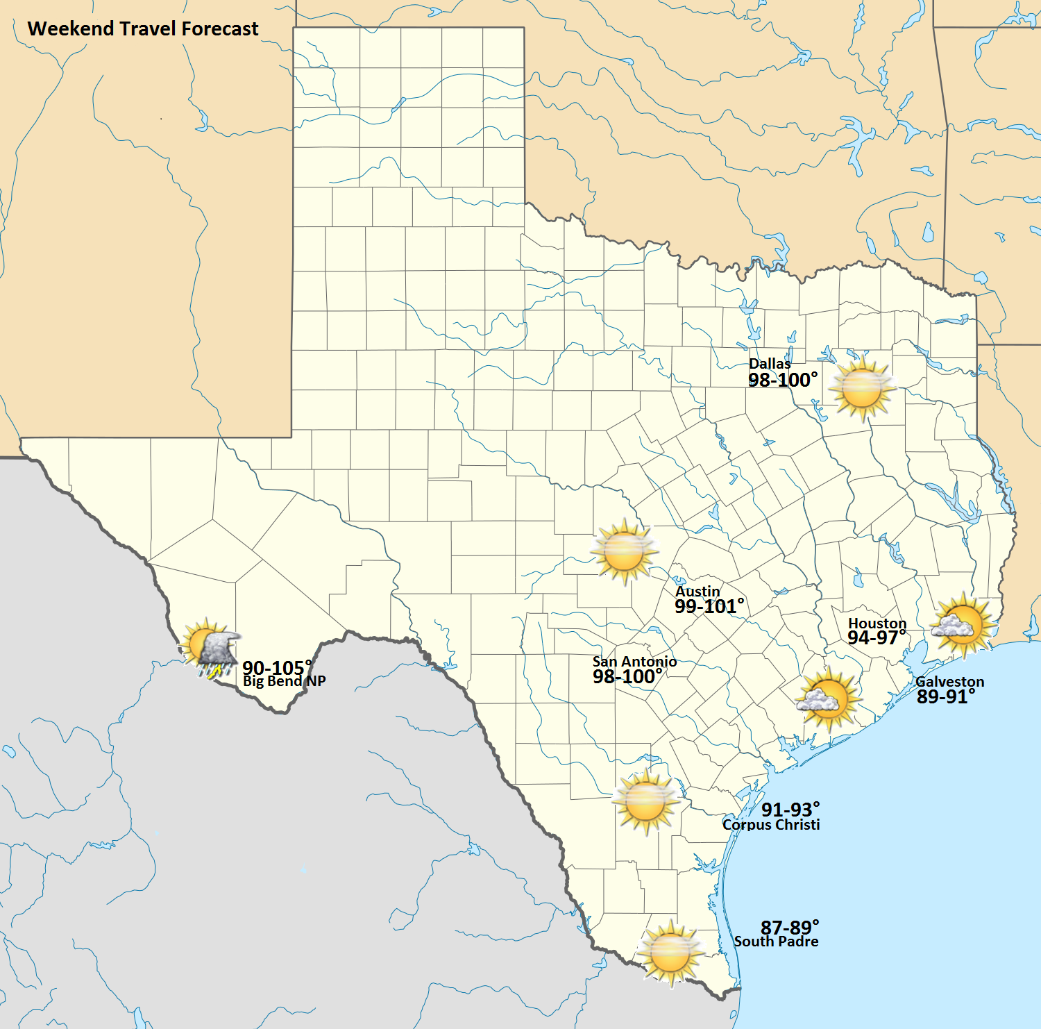
Again, just a note, the temperature at Big Bend is the range from high elevations (~90°) to lower elevations (~105°). All in all, it looks like a mostly trouble-free, hot weekend across most of Texas.

See full post

Why Houston is seeing more warm nights

Let’s talk about minimum temperatures. The city of Houston has now recorded five consecutive mornings of 80-degree plus temperatures. This average of 81.6 degrees trails only a five-day period in 2011 (81.8 degrees) for the warmest stretch of minimum temperatures in about 120 years of records for the city of Houston.

Looking across the entire globe, climate scientists have been noticing this trend for some time—that as the planet warms nighttime temperatures appear to be warming faster than daytime temperatures. In Chapter 2 of the latest report from the Intergovernmental Panel on Climate Change, the authors write, “Confidence of accelerated increases in minimum temperature extremes compared to maximum temperature extremes is high due to the more consistent patterns of warming in minimum temperature extremes globally.”

Why is this happening?

Now there’s no question that development around northern Houston has played some role in warmer temperatures around the National Weather Service’s official station at Bush Intercontinental Airport. This is the so-called Urban Heat Island effect. However it would be wrong to attribute the nighttime warming to urbanization alone, as the global trends are pretty clear. Warmer nights locally are consistent with a warmer world.

How the day-night thickness of the boundary layer may affect temperatures. (Richard Davy/Bjerknes Center)

See full post

Record warmth for July continues in Houston

Houston had another staggeringly warm morning today, with the low only falling to 81 degrees. This continues the warmest start to July, in terms of average daily minimum temperature, on record for the city of Houston. We’ve now recorded five consecutive mornings with a temperature of 80 degrees or higher, which is also a record. Some readers have asked why this warmth is occurring, and I will dive a bit deeper into that question later today.

For now, let’s look at the forecast.

Today through Monday

The forecast remains more or less set in stone. With high pressure in place over Texas, the region is likely to continue to see high temperatures in the mid-90s, lows around 80 degrees, and mostly sunny skies. With the high weakening a bit this weekend we might see a few scattered showers on Saturday, or perhaps Sunday, but by and large the region is going to remain dry and hot. Daily high temperatures and humidity should remain just below the level at which the National Weather Service would issue a heat advisory, however.

Tuesday through Thursday

Pressures should begin to fall a little bit by Tuesday or so, and in addition we should see some rising instability in the atmosphere.

In these forecasts from the European model, we can see pressure falling from this weekend (top image) to more moderate levels from Tuesday through Friday next week. (Weather Bell)
In these forecasts from the European model, we can see pressure falling from this weekend (top image) to more moderate levels from Tuesday through Friday next week (bottom image). (Weather Bell)

See full post

Finally, after the Tax Day floods, the Addicks and Barker Reservoirs have emptied

Nearly three months have come and gone since the Tax Day Floods ravaged the Houston area in April. As you may recall, during these storms rain fell at rates as high as 1 inch in just 5 minutes over parts of Harris County, with a maximum hourly rate of 4.7 inches. The rain topped out at 16.7 inches in just 12 hours over western Harris County. All told, Harris County averaged 7.75″ of rainfall for the event— equivalent to 240 billion gallons of water falling on the area.

One of the most memorable aspects of those floods came when both the Addicks and Barker Reservoirs filled up, and flooded the adjacent Highway 6. These watersheds located upstream of Houston provide flood damage reduction along Buffalo Bayou downstream of the reservoirs and through the center of the city.

A view of the flooded Addicks Reservoir. (John Chandler/Flickr)

See full post