Storms possible today, and rain returns later this week to Houston

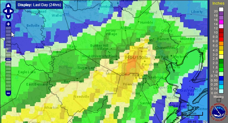
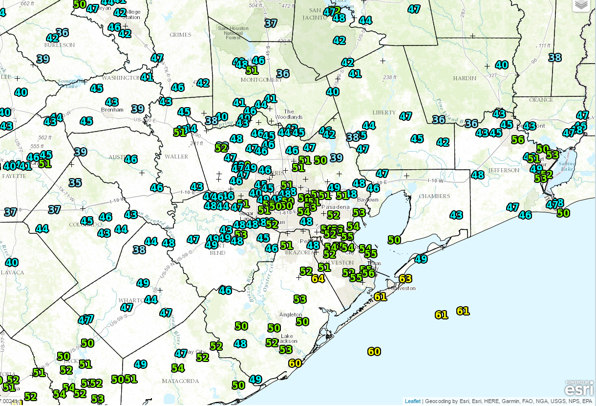
It’s another warm morning across Houston, with temperatures generally having fallen only to about 70 degrees. The main concern today will be the possibility of some storms and heavy rain along with the passage of a cold front.

Today

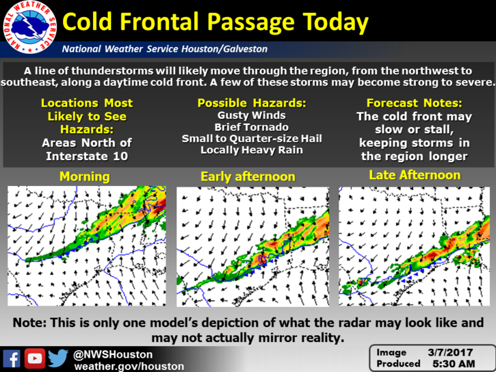
A cold front now in north Texas will move down toward the Houston area, likely pushing through the city during the mid-afternoon hours, and the off the coast by late afternoon. Due to decent moisture levels and and lift associated with the front, much of the area is likely to see some moderate to briefly heavy rain with the front’s passage. I’m expecting on the order of 0.5 inch to 1.0 inch or so, late this morning and during the afternoon hours. The storms may slow, or even stall along the cost, producing more rain there. Along with the front there will likely be some embedded thunderstorms, and a slight chance of some hail. After the front passes tonight look for temperatures to fall into the mid- to upper-50s.

(National Weather Service)

Wednesday

With northerly winds and partly cloudy skies the day will be moderately cooler, with highs in the low 70s. A very slight chance of rain returns during the late afternoon and evening hours. Most of the cooler air is gone by Wednesday night, allowing low temperatures to fall only into the 60s.

(Space City Weather is sponsored this month by an anonymous donor.)

See full post

See lightning over Houston in an incredible new way

Back in November, meteorologists were euphoric as a satellite named GOES-R (now GOES-16) was launched into orbit. “GOES” stands for “Geostationary Operational Environmental Satellite.” For meteorologists, it represents the future of weather observation from space. The satellite is now sending back imagery and data in an experimental, non-operational capacity. GOES-16 will be declared operational and unleashed for use in forecasting and observations later this year.

There’s a lot to love in GOES-16. We’ll have higher resolution imagery from a satellite than we’ve ever had in North America. In fact, at times, the satellite will be capable of sending back pictures every 30 seconds. By comparison, that’s more frequent than what a land-based Doppler radar typically scans. It will have 16 bands of imagery compared to five bands on the current GOES fleet. These satellites will give us more to look at, more to study, and more high quality data that will be ingested in weather models to help with short and medium range forecasts. It will also have the ability to see lightning.

Geostationary Lightning Mapper

The geostationary lightning mapper, or GLM, attached to GOES-16 can detect changes in a scene that indicate there’s lightning present. It’s the first such operational lightning mapper in orbit. The GLM will give us a capability to see and study lightning in a brand new way. It will also allow us to build up a historical database of lightning across much of the Western Hemisphere, including the tropics and deep oceans, where we lack a lot of good observational data. Best of all, it will allow for some really cool visualizations of storms.

See full post

After Sunday’s heavy rains, more storms possible Tuesday in Houston

Obviously, the big story this weekend was heavier than anticipated rainfall on Sunday. Our Friday forecast for the weekend was not particularly good. We missed on the potential for heavy rainfall and storms on Sunday, when some areas of southern Harris County recorded as much as 6 inches of rain. While there were no major flooding events as a result of the rain, and most of the region received 1.5 inches of rain or less, it is nonetheless regretful. It also serves as a reminder of the challenges of predicting heavy rainfall along the Gulf of Mexico.

Rain accumulation from early Sunday through early Monday. (NOAA)

Monday

It’s another very warm morning for early spring, with low temperatures only falling to around 70 degrees for most of the Houston area. After Sunday’s widespread showers, moisture levels remain fairly high over the region, but there’s not the same forcing to really drive the development of rain. As a result I think we’ll see some scattered rain showers later this morning and afternoon, but nothing too widespread. Highs will be around 80.

(Space City Weather is sponsored this month by an anonymous donor)

See full post

Mixed reviews for Houston’s weekend weather

Good morning, and happy Go Texan Day, y’all! Today looks great, but this weekend should get mixed reviews, as we’ll be dealing with some rain chances dampening things a bit. On to the details.

Today & Saturday morning

Today will be a fine day. We are starting off a bit chilly this morning, with a lot of 40s on the board north and west of Houston.

Another cool start this morning, with plenty of 40s and low 50s in the area. (NOAA/NWS)


It looks mostly sunny and dry this morning and afternoon. We’ll have some high clouds skirting through from time to time, but overall it looks to be a nice day. Temperatures should get up to near 70 degrees with a modest breeze.

It should be a quiet evening, though it won’t be quite as cool as this morning or Thursday morning. Temperatures should start Saturday about five to ten degrees warmer than those days. Clouds will begin to increase tonight as well, leading to a mostly cloudy, but likely quiet Saturday morning. It *should* be good weather for the Downtown Rodeo Parade or the Rodeo Run. We can’t entirely rule out a sprinkle or some light rain, but steadier rain should hold off until after Noon.

Saturday’s rain *should* hold off until after the Rodeo Run and Downtown Parade.


You’ll still want to keep tabs on the forecast before you head out in the morning, just to be safe.

See full post