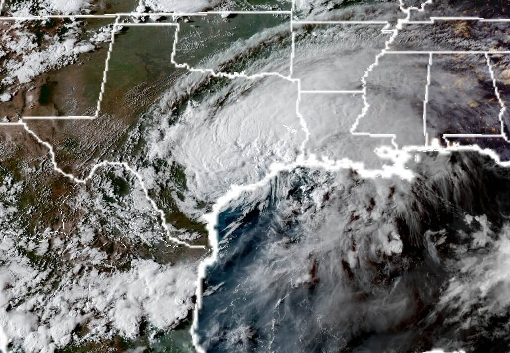
Sunday, 8:40pm CT—As darkness descends upon Houston, another very wet night has already begun for the region. So far this evening, the heaviest rains have fallen across the western part of the region, including the Katy area. As much as 6.5 inches of rain have fallen near Cinco Ranch from 5pm to 8pm. A flash flood emergency is continuing for pretty much the entire Houston area tonight.
Tropical Storm Harvey, at sunset over Houston. Sunday. (NOAA)
Addicks and Barker
These rains have occurred near, and over the massive Addicks and Barker reservoirs on the west side of the city. Earlier today, the US Army Corps of Engineers said it would have to make controlled releases into Buffalo Bayou (which already is beyond flood stage) in order to prevent a more catastrophic release later next week. “This flood event will exceed the 2016 Tax Day Flood elevations,” said Col. Lars Zetterstrom, Galveston District commander.
It seems probable that some homes near Clay Road and Eldridge, and in the vicinity of the Westpark Toll Road and Highway 99 will see water remain in homes for up to two months. That is not a misprint.
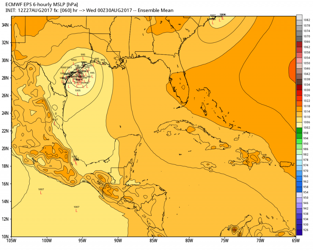
Today, there has been a lot of chatter on social media about the potential for the remnants of Harvey to move offshore into the Gulf of Mexico by around Monday, whereupon it might strengthen into a hurricane again and make a second landfall over Houston. This is obviously a scary scenario, but frankly it’s not one we’re losing too much sleep about here. The main threat for Houston remains heavy rains and inland flooding. But let’s discuss this anyway, because we’ve had a lot of questions regarding it.
For readers who been with us a few days, you’ll recall that we’ve been discussing the “Euro special” scenario since Thursday. The idea is that a drifting Harvey would wander southeast this weekend, and move back over the Gulf of Mexico. That seems increasingly likely to occur, although it’s far from locked in. Even with the European model, which has most consistently held to this solution, only about two-thirds of the ensemble members have the storm offshore on Tuesday.
European ensemble members for Harvey’s location on Tuesday evening. (Weather Bell)
While the center may move offshore for a day or two, the fact remains that Harvey no longer has an inner core, and what remains of it will deteriorate further while it is over land Sunday and at least part of Monday. This, along with its proximity to land, should limit intensification. In the official National Hurricane Center forecast released Sunday afternoon, hurricane scientists predicted that it may attain 45 mph winds offshore, but was not likely to strengthen further.
Good afternoon. Rain rates today have been more manageable in the area. We’ve even had reports of sunshine in spots. Over the next few hours, the weather is going to likely deteriorate once more. Current problems will continue and new ones will crop up, but we feel that we will probably see less rain overall tonight than we did last night in the Houston area. That being said, tonight’s rains come with a bit more uncertainty than last night’s. Let’s explain.
Now
Harvey is centered about 25 miles from Victoria. This is further east than Harvey was at this time yesterday. The setup has changed a bit, with a weak boundary along I-10 and flow that’s directed more southeast to northwest from the Gulf.
What does this mean? It means that varying intensities of rainfall are likely tonight south of I-10. Again, this isn’t optimal, but my hope is that the rains will remain manageable south and southeast of Houston. Folks in those areas will need to stay alert and keep the guard up overnight, but rain totals (and the hope is VERY importantly, the rain rates) should be less than last night.
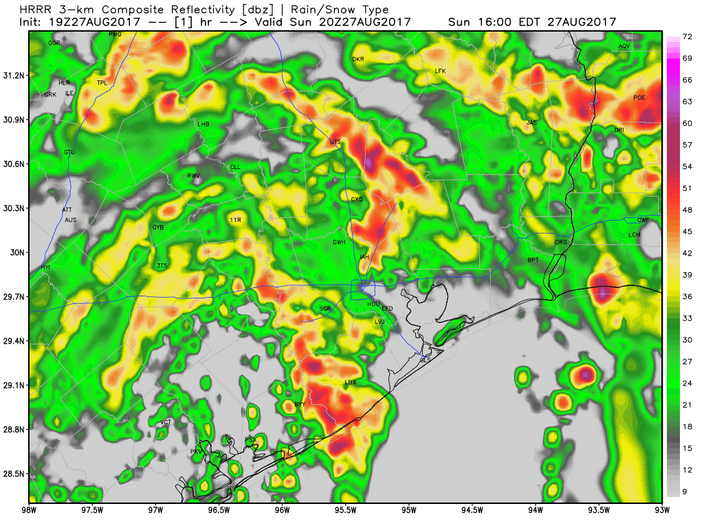
Overnight HRRR model projects the heaviest rains near Beaumont/Port Arthur and north of I-10 in Houston. (Weather Bell)
North of I-10,it’s similar, but with more rain and fewer breaks. Expect occasional 1-3″ per hour rain rates in those areas. This will exacerbate already near-record levels of flooding on Cypress Creek and other bodies of water north of Houston.
On average, I would expect 3-7″ south and 4-8″ north, but there is most certainly a risk of higher amounts in spots. The heavy rains near Port Arthur and Beaumont should add up to 5-10″ or more.
Tomorrow & Tuesday
Looking ahead, no new news to report. After tonight, rainfall will continue sporadically and heavily at times through tomorrow, similar to what we saw today, perhaps with a few less breaks though unfortunately. Harvey will emerge back out over the Gulf near Matagorda, and a Tropical Storm Watch was reissued from Sargent to San Luis Pass with the National Hurricane Center’s 4 PM advisory. Eric will have a post shortly on that aspect of the storm, but please, use your bandwidth to deal with the rain and flooding around Houston right now. That’s the issue we have to focus on.
We’ll have another post on the forecast this evening. Stay safe.
Continuing our theme of giving you the latest forecast information, here’s an early afternoon update.
Now
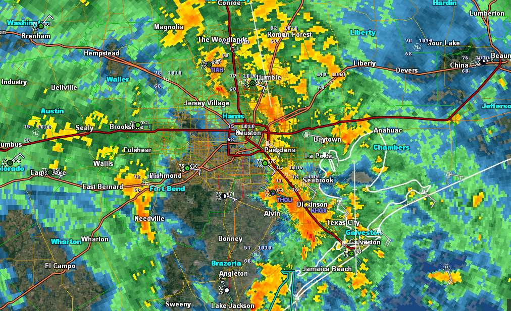
Some good news for some folks. Dry air has punched in west of I-45 as of 12:30, and in some areas, we’re getting a nice dry period. Other areas are still seeing rains, but they’re falling at manageable rates. We continue to see isolated tornado warnings pop up all over the area.
Radar around 12:30 PM shows breaks in the rain, but more localized heavy rainfall. (GR Level 3)
Rest of Today
Looking at high-resolution weather models, I think we’re going to see this pattern continue. Occasional drying moves around the area, with pockets of heavier rain at times. Some places may see 1-3″ in an hour. This will limit improvement, but outside of areas where runoff from last night is still flowing through the system, it shouldn’t make things terribly worse. Not ideal, but manageable for the most part. Tornado Warnings will continue to pop up across the region, so if you can safely find shelter if a warnings is issued, do so.
Tonight
A couple points. The setup is not identical to last night, but there are a number of similarities. And obviously that concerns us. Yesterday, we could say with high confidence that Houston was going to have a rough night. Tonight, we can only say that someone in the Houston area is going to have a rough night. Our highest resolution, shortest term model, the HRRR, has the heaviest rain tonight between Baytown and Beaumont. The Texas Tech WRF model develops another period of heavy rain west of Houston and progresses it eastward across the city (not as intense or permanent as last night, but still bad). The NAM models tend to like the heaviest rain over the Inner Loop, and the GFS has the heaviest west of Houston. Last night, they all had Houston getting hammered. So tonight’s forecast is a shrug forecast. I’m hoping we’ll gain more clarity with our mid to late afternoon update in a few hours.
Tomorrow
Right now, despite the model disagreements, I would expect a repeat of today’s weather after sunrise on Monday: Rain, heavy at times, with occasional breaks. And a continued isolated tornado threat. More on this later.