Harvey almost certainly the biggest US flood-producing storm

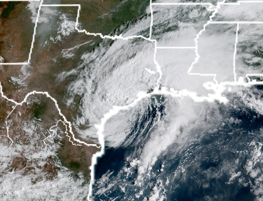
Monday, 1pm CT—Houston remains in the midst of Hurricane Harvey’s devastating aftermath, and we are weeks if not months away from a full accounting of its toll on the fourth largest city in the United States. And while a definitive account of its epic proportions will have to wait, we can at least begin to make some preliminary assessments.

In this post we will discuss how Harvey compares to other major flood storms in US history, and also how it stacks up to the region’s previous flooding event of record, Tropical Storm Allison. (Spoiler alert: Allison had a good run, but Harvey has forever dethroned her).

Mississippi discharges

The Texas state climatologist, John Nielsen-Gammon, has been closely tracking Harvey and its attendant flooding. To gauge the overall impact of a rain event, he uses a metric that defines a target zone of 20,000 square miles (about the size of West Virginia, or about 30 times the size of the city of Houston), and then measures the rainfall rate over a 120-hour period in comparison to the discharge rate of the Mississippi River. Here are the top 10 Gulf Coast flood events, as measured in “Mississippi River discharges” over that time:

  • 3.6 Hurricane Harvey 2017 (estimate)
  • 3.4 Hurricane Beulah, 1967
  • 3.1 Brazos River flooding, 1899
  • 2.8 Hurricane Georges, 1998
  • 2.6 Southeast Texas flooding, 1994
  • 2.5 Louisiana floods, June 1940
  • 2.4 Tropical Storm Alberto, 1994
  • 2.3 November Texas floods, 1940
  • 2.3 Louisiana floods, 1953
  • 2.3 Tropical Storm Allison, 2001

Note that the initial estimate for Harvey may be too low. As of Monday morning, Neilsen-Gammon’s hand estimate for Harvey to date was 3.1, but more heavy rains were falling in the target area and a full five days not reached. Already, for 72 hours, Nielsen-Gammon said Harvey is the greatest event over this shorter time scale.

Under this metric of rainfall over a large area, then, Harvey will very likely produce the greatest total amount of rainfall in the United States from any single storm, at least during the last 120 years. (the Gulf coast is by far the most susceptible US regions to such events due to its proximity to the warm, humid body of tropical water).

See full post

Harvey late Monday morning: Rains remain, but storm finally moving

Monday, 10:30am CT—There is no way to escape the reality of the situation on the ground this morning: Houston bayous are flooding, and even after the region has received 30 inches of rain during the last two days, more is now falling over the central Houston area. It is a catastrophic situation. Finally, however, the end is in sight. Another day or two of this …

Harvey

Harvey remains barely a tropical storm, but its center moved into the Gulf of Mexico near Matagorda Bay this morning. Presently moving to the southeast at about 5 mph, some slight strengthening is possible over the next day or two as Harvey turns east, then northeast, but as discussed yesterday we are not too concerned about this possibility due to the lack of an organized core, and additionally some drier air is working into the storm. (See official track forecast).

Tropical Storm Harvey at 10am CT on Monday. (NOAA)

Overall, Harvey’s movement into the Gulf may be a positive development, because the storm is getting closer to being picked up by lower pressure in the Midwestern United States, which should lift it north. By later Tuesday, or Wednesday, we should hopefully be on the back side of the storm, with northerly winds helping to push water from inland bayous out to the Gulf of Mexico. Heavy rains should end, hopefully, by Wednesday or Wednesday night.

See full post

Early Monday morning Harvey Forecast Update

Good morning. Since about midnight, while it has continued to rain, totals have been held down a bit. Most of Harris County has seen less than an inch in that time, while a few spots west of Harris County and to the northeast, especially into Chambers and Liberty Counties have seen 1-3″ of rain. No rain helps, but these sorts of rains don’t hurt quite as badly.

Now

Radar this morning is opening up on a mostly positive note for us. Yes, again, more rain in the area, but a better view than 24 hours ago, and much better than some forecast models had indicated even 8-12 hours ago.

Radar as of 6 AM shows the heaviest rains oriented from about Beaumont and Lake Charles northwest to Livingston and Madisonville. (GR Level 3).

Scattered showers persist west of Houston and in other parts of the area.

Monday

Harvey has re-emerged in the Gulf near Matagorda. We, along with the National Hurricane Center, continue to believe that while Harvey will travel over the Gulf the next couple days, only modest re-organization is expected. Eric covered this in detail last night, and I see no reason things have changed much overnight. We don’t want you worrying about that, and everyone’s focus should continue to be on the rainfall forecast and ongoing flooding.

So what about rain today. Radar isn’t too alarming this morning, but we do expect rains to fill back in a bit as the day progresses. This is certainly not what folks want to hear, but I do believe that in most cases, the rainfall *rates* will be manageable enough to limit substantial new problems from occurring. What this will likely do is lead to some rises again on area bayous that have crested and are dropping now. Those that haven’t crested will continue to rise, albeit hopefully at a slower pace, despite new rains.

Tonight & Tuesday

As we go into tonight and tomorrow, expect continued periods of rain. Most of the time, rates should continue to be manageable so that things don’t worsen, but I can’t entirely rule out some heavier rainfall at times until Harvey comes ashore in Louisiana again on Tuesday night or Wednesday morning.

We figured this would be at least a four or five-day event for Houston, with the worst rains front-loaded in the first two or three days. Today begins day three, so we’re past the halfway point, and hopefully past most of the worst of the rains. That’s not to say we don’t have additional problems ahead, but our hope is that we can manage what is to come. We’ll have more for you a bit later this morning.

Posted at 6:20 AM Monday by Matt

Harvey late night: Water levels rising across Houston metro area

Monday, 12:30am CT—Nearly every bayou, river, stream, and waterway in and around Harris County has reached the top of its banks, or exceeded them. Flooding is occurring in multiple neighborhoods across the region, and worse is still to come. It is anything but hyperbole to say this is the most catastrophic flooding event in the city of Houston’s history. Tropical Storm Allison, a 500-year-flood, held the title for just 16 years.

This radar image (below) from around midnight shows what the region is up against tonight, and in the coming days. As the center of Tropical Storm Harvey drifts toward Matagorda Bay, it is producing a huge, 400-mile arc of showers that stretches all the way from south of the Texas-Mexico border into The Woodlands. This is an awesome, terrifying feat of nature—a freight train laden with moisture bound for the upper Texas coast.

Radar image at midnight, Sunday. (Intellicast)

Truthfully, we don’t really know what will happen next. Some drier air has moved into the southern half of the region from the west tonight, and this has led to some drying behind the line of showers, from El Campo to Galveston. Some of the short-term, high resolution models suggest the heavier activity will now slowly move off to the northeast of Houston tonight, toward Beaumont and Western Louisiana. (Beaumont is having an historic rain event too, by the way). This may offer a short reprieve for parts of Houston, and truthfully anything is welcome.

But with Harvey’s center so close by, we can almost certainly expect more to come. Tonight, western areas of Houston, including Katy, Cinco Ranch and other communities along the Sam Houston Tollway, picked up 7 to 10 inches of rain in just six hours. Who will be hit so hard next? We probably will have to worry about these mega-rain-bombs for another two or three days, perhaps into Wednesday, or Wednesday night. And what will that mean for Houston, its bayous, and its increasingly beleaguered citizenry?

Truly, we don’t know what happens next. This is uncharted territory for Houston in terms of flooding and potential disruption to our communities. Certainly, some help is on the way from the state and federal government. But in the meantime, be kind to your neighbors. We have seen incredible acts of valor and bravery and heroism during these last 36 hours from common, ordinary people. We have saved lives, and made the lives of others just that tiniest bit easier. We will need much more of this to make it out the other side.

Posted by Eric at 12:30am CT on Monday by Eric