A decent fall weekend for Houston

After a gray start, Thursday turned out to be pretty nice in Houston proper. Actually, Thursday was about as California of a day as you can find in Houston. It really did feel nice. Clouds were a bit more stubborn north and west of Houston. Things should change there today. Friday is starting off cool and somewhat crisp. It looks like we warm up again this weekend and next week, but we should stay safely under the obscene levels we hit earlier this week. The details…

Friday through Sunday

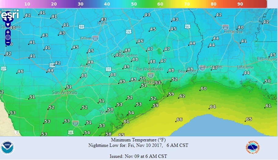
We’re starting this morning on the cool side for sure. Middle or upper 40s dominate north and west, with low or mid-50s dominating south and east.

A chilly start north and west of Houston today! (NOAA)

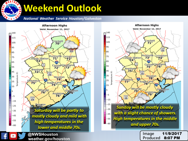
Expect a pretty nice day today. Any clouds or fog south and west should fade. It’ll be partly to mostly sunny and mild, with temperatures warming up this afternoon into the 60s to about 70° in spots. A quiet and pleasant night tonight; expect morning lows on Saturday to be about one to four degrees warmer than this morning on average. Likewise, daytime highs will be similarly warmer with a mix of clouds and sun. As of now we don’t expect any rain Saturday. But a sprinkle or shower may be possible late, well south of Houston.

How about Sunday? Well, we’ll see an onshore flow return, along with clouds, so expect a much warmer start to the day (low 60s on average). During the afternoon, there will be a few scattered showers around. Otherwise, partly to mostly cloudy skies dominate, and we’ll top off in the mid-70s or perhaps upper-70s with enough sunshine.

You may dodge a few raindrops in a few spots on Sunday, but otherwise, the weekend is looking pretty good. (NWS Houston)

So, weekend plans outdoors? I’d try to do them Saturday, but if you have to go Sunday, odds still favor you probably getting through the day without issue..

See full post

Coldest night of November coming, weekend looks great for Houston

A few stray, light showers remain across Houston early this morning, but for the most part rain chances have passed. Most of the area got between a light sprinkle and two tenths of an inch of rainfall. Now, we can enjoy fall-like weather with mostly low humidity through the early part of next week.

Thursday and Friday

Clouds will give way to sunshine later this morning, but Thursday should still see relatively cool weather with highs in the mid- to upper-60s. On Friday, highs may top out at around 70 degrees. Northerly winds should allow low temperatures on Friday morning to get into the low 50s for central Houston, and upper 50s on Saturday morning. All in all, these will be exceptionally pleasant days after Houston’s long summer.

Friday morning will be the coldest night of November so far. (NOAA)

Saturday and Sunday

The weekend warms up a little, with highs probably rising into the mid-70s. Some southeasterly winds will push humidity back up a little bit, and lead to warmer nights with lows of around 60 degrees. However, a weak cool front should at least halt this rise in temperatures and humidity for a few days. A few showers may be possible as this front moves into the area on Sunday, but I don’t think most people will see any rainfall.

See full post

Cooler weather returns and a (very) early Thanksgiving outlook

After more record warmth on Tuesday—Hobby Airport set a record high of 89 degrees, breaking an old mark of 87 degrees—a cold front finally pushed through the region during the late evening hours. Fall, finally, has returned to Houston for awhile.

Wednesday

Today will be cool, with highs in the low- to mid-60s, with increasing rain chances this afternoon and evening. An upper-level disturbance will track from west to east across Texas today, and this should bring some decent rain chances to us, especially for areas north of Interstate 10. Overall, accumulations still look pretty slight for Houston, with most areas getting a tenth or two of an inch of rain, but the leaden skies will add to what will be a winter-like, gray day for Houston.

Rain accumulation forecast for Wednesday and Thursday. (NOAA)

Thursday and Friday

These days still look like the pick of the litter for the region, with partly to mostly sunny skies, and highs in the upper 60s to 70 degrees. Overnight lows should range from the upper 40s for inland areas to upper 50s closer to the coast. Just splendid fall weather.

See full post

Less than a day before a strong cold front reaches Houston

Houston continued to set record high temperatures on Monday—a mark of 89 degrees at both Bush Intercontinental and Hobby airports broke records at each location by a degree. Fortunately, this abnormally warm weather for November will finally come to an end later today, or tonight.

Today

We’ll have one more day with temperatures in the upper-80s across the region before a cold front pushes into Houston. As of 6:45am CT, the front was draped across Central Texas, and slowly pushing to the southeast. Temperatures (and especially dewpoints, which denote drier air) are considerably cooler behind it.

Cold front location at 6:45am CT on Tuesday. (National Weather Service)

The front is moving a bit faster than expected, so it should arrive in the Houston area later this evening, and push off the coast by midnight, or shortly thereafter. Before then, we’ll be partly to mostly cloudy, and unseasonably warm. Afterwards, cold.

See full post