Houston setting records for warm nights as 90-degree days loom

After the potential for storms fizzled on Saturday night—the worst of them simply passed well north of Houston—the region’s story now turns toward heat as we get deeper into May and closer to June. (We are but one month and one day away from the summer solstice, when the Sun reaches the highest point in the sky). Although daytime highs have not been at all oppressive, our nights have turned muggy and warm. On Sunday College Station (77 degrees) and Bush Intercontinental Airport (78) both tied records for warmest “minimum” temperatures, and Houston’s Hobby Airport (79) broke a record of 78 degrees set in 2017. We’re experiencing more of the same on Monday morning.

Monday

Today should eventually bring mostly sunny skies, allowing highs to tick up into the upper 80s, if not 90 degrees. Perhaps the most noticeable aspect of our weather will be southeasterly winds really starting to blow this afternoon, perhaps gusting to 25mph or higher.

Severe weather outlook for Monday and Monday night. (NOAA)

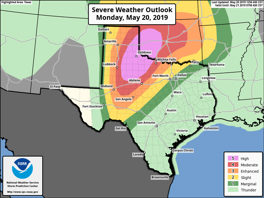
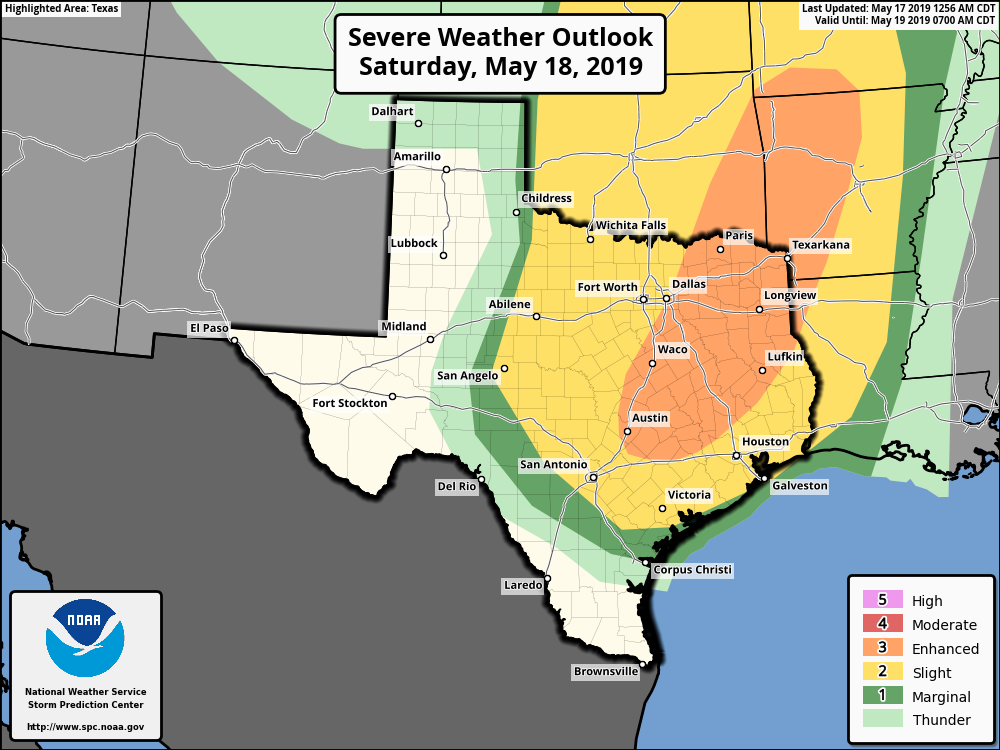
This will offer a nice illustration of how weather around the country (indeed, the world) is connected). These winds will be blowing from high pressure in the east toward low pressure and a strong storm system over northern Texas and Oklahoma. If you’re traveling toward the Panhandle today, take care, as there is a high potential for severe weather, including some very strong tornadoes. For Houston, Monday night will be another warm one.

See full post

Storms possible Saturday night, with warmer weather next week

After a warm, and sunny week, we’ll see the potential for some more unsettled weather this weekend. The best chance of storms will come Saturday night, and if you’re planning outdoor activities this weekend Sunday looks to be the nicer day.

Friday

After days of sunshine, partly cloudy skies will return today. This will be due in part to an increased flow from the Gulf of Mexico—you’ll probably notice that in winds gusting up to about 20 mph this afternoon. Some scattered showers may pop up this afternoon, but overall I expect only about 20 percent of the area will receive rain. Highs today will likely top out in the mid-80s, and temperatures tonight will probably be about five degrees warmer than most of this week. Houston has had some spectacular evenings this week, but I’m afraid that kind of somewhat dry weather is about to go away as summer looms.

Saturday through Sunday morning

The forecast for the weekend is still a bit murky, with bust potential. By this I mean there’s definitely enough instability to fire off some severe storms beginning Saturday evening through Sunday morning (mostly hail and damaging winds), but there’s about an equal chance that the line of severe storms falls apart as it nears the Houston metro area.

NOAA storm outlook for Saturday and Saturday night.

In any case, Saturday will be mostly cloudy, with highs in the mid-80s, and scattered showers throughout the daylight hours. Storm chances will pick up during the overnight hours as the aforementioned storm system moves from west to east. If you’re traveling to Austin, or anywhere on North Texas on Saturday you’ll definitely want to pay attention to the weather, because it is likely that strong storms will develop along Interstate 35.

Whatever ends up moving through the Houston metro area on Saturday night and Sunday morning should be short-lived, so we don’t have any major concerns about flooding, and accumulations should for the most part measure between 0.5 and 1.5 inches of rain.

See full post

What the heck was up with last week’s hail in Houston?

Last week’s storm system was mostly about the heavy rain and flooding, as Eric summed up nicely here. But the story that I think was most fascinating, meteorologically, was the hailstorm that hit some parts of the Houston area on Thursday night. The National Weather Service Houston office collected over 20 hail reports from the event, more than half of which were golf ball size hail or larger.

https://twitter.com/VortexChasing/status/1126686637394518016

Houston doesn’t often get hail this big over this wide an area. So what happened here? Why did we have so much big hail last Thursday?

Houston doesn’t see a lot of hail

If you look at the map of annual average 1+ inch diameter hail days per year (this from 2003-2012), you’ll notice Houston is mostly on the outside looking in at significant hail reports.

Severe hail reports are most common from Missouri and Kansas into South Dakota. (NOAA)

Why is this the case? For one, thunderstorm updrafts are needed to allow for the water droplets that become hailstones to get above the freezing level. Houston is a warm place, and that freezing level is often too high and the storms not powerful enough to carry those droplets high enough for large hail to form. Our lower freezing levels occur in winter and spring, making hail more likely then. In fact, of the 62 hail reports of 2″ in diameter or larger in NOAA’s storm events database since 1950 in Harris County and adjacent counties, only 3 of those reports have occurred outside of January through May. The average hail maxima is also where it is because they simply get more powerful, supercell thunderstorms with violent updrafts in the Plains.

See full post

Some storm chances this week, but a tricky forecast for Houston

It’s another clear and pleasant morning—low temperatures in the mid- to upper-60s are not to be taken for granted this time of year—and our forecast remains on track with May-like weather ahead. We’re still anticipating some rain, and the potential for storms later Saturday night and Sunday morning, but there is no guarantee this will happen.

Thursday

Overall, today will be similar to Wednesday, with mostly sunny skies and high temperatures in the mid-80s. Some high resolution models are showing the potential for some scattered storms that could pop up this afternoon, due to the combination of the sea breeze and daytime heating. The most likely window for these appears to be from 2pm to 6pm this afternoon, with areas along and west of Interstate 45 most favored. These shouldn’t pose too much of a problem unless they develop directly over freeways at rush hour.

The HRRR model shows the potential for at least isolated thunderstorms on Thursday. (Weather Bell)

Friday

This should be a partly sunny day, with highs in the mid-80s, and another chance of scattered to isolated showers and thunderstorms. More clouds will likely move in later on Friday and Friday night, leading to warmer overnight conditions for the region in the mid-70s.

See full post