Storms likely to reach Houston Saturday night, hot thereafter

Good morning. We’re going to have a seasonable end of the work week, with a healthy chance of rain this weekend—the timing is most likely Saturday night, so don’t cancel those outdoor plans just yet—and then much warmer weather next week. It’s not June yet, but with high pressure moving in temperatures will go up and rain chances will go down.

Wednesday

Today’s forecast will feature partly to mostly sunny skies. We may see a very few scattered showers over the region, especially to the southwest of Houston, but mostly we’re going to see sunshine. Highs will be in the mid-80s and overnight lows will drop down to around 70 degrees. In short, this is pretty standard weather for May. And while it’s fairly warm, this is nothing like what’s coming.
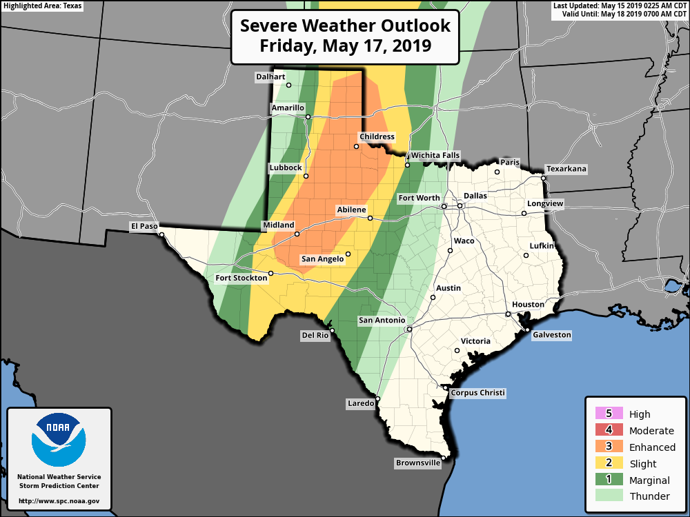
Severe storms will affect West Texas on Friday. (NOAA)

Thursday and Friday

High pressure should keep a lid on all but scattered showers to end the work week, and allow partly to mostly sunny skies across Houston. Highs will likely reach into the mid- to upper-80s with southerly, humid winds. A reminder, if you’re traveling to West Texas or the Panhandle on Friday, check your travel plans closely, as a storm system will likely be moving across that part of the country with the potential to produce severe weather, including tornadoes.

See full post

Expect a typical May week, with a chance for showers this weekend

After Monday’s superb weather—seriously, was that the nicest day of 2019 so far?—we’re going to return to a more May-like pattern with increasing humidity and warmer temperatures for the rest of the week. We still have some concerns about the potential for storms this weekend, but as for now it appears like the more severe weather will remain north and west of Houston.

Tuesday

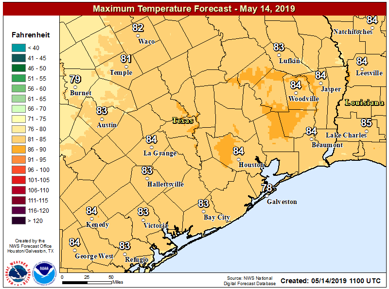
It is warmer across the Houston area this morning, with lows generally down around 70 degrees in the city, and a few degrees cooler up north. With partly sunny skies later this afternoon, we can expect high temperatures to reach the mid-80s. We will see some slight rain chances in Houston, perhaps 20 percent or so, with the best potential to the southwest of the region over Matagorda, Wharton, and Colorado counties. Accumulations should be less than a tenth of an inch, or two.

Temperatures Tuesday will be typical of May in Houston. (National Weather Service)

Wednesday and Thursday

These should be a similar days to Tuesday, with low, but non-zero rain chances. Temperatures will be on the upswing, with highs in the mid, and possibly upper-80s by Thursday. Overnight lows will remain decent for mid-May, likely dropping to around 70 degrees in the city of Houston.

See full post

Assessing Houston’s Stage 3 flood, looking ahead to drier weather

Houston wrapped up five very wet days on Saturday evening, as a weak cold front finally ushered an extremely moist air mass off to the east of the region, and stabilized the atmosphere. Before discussing out more sedate weather ahead, first let’s look back at the five-day rain totals, and whether the flood scale we implemented this month was effective.

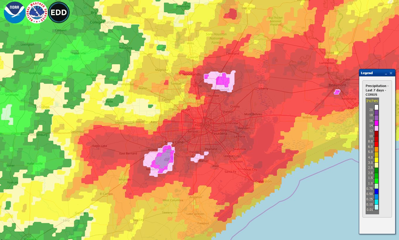
Rainfall totals for the last seven days. Click for full-size image. (National Weather Service)

This map shows rain totals for the last seven days, and encapsulates the rain event that lasted from last Tuesday through Saturday. The greatest rain totals fell near Sugar Land, in the southwest part of the region, Kingwood, to the northeast, and Beaumont. One area near Sugar Land received 18+ inches, while the bright purple areas indicate 14+ inches. Overall, most of the Houston metro area received 6 to 12 inches of rain. Interestingly, one does not have to go all that far from the metro area to find a region, in this case Brenham, that received less than 2 inches of rain. This gives you some idea of the challenge of forecasting these kinds of precipitation events.

Flood scale

We introduced a flood scale to provide readers with a general expectation about upcoming flood events. Initially, we rated this five-day event as a “Stage 2 flood,” but after the intensity of Tuesday’s storms—which turned out to be the worst of the five days—we bumped these floods up to a Stage 3 event on Wednesday.

The May, 2019 floods ended up a Stage 3 event. (Space City Weather)

This feels about right in hindsight, given the five-day accumulations over some locations, but we’d welcome any comments or thoughts you have about the scale as we continue to refine it. Thursday night’s hail was also notable, and Matt may have some more to say about that the next day or two. Now, on to the forecast.

Monday

After last week’s storms, this week’s weather will be somewhat anti-climatic. Monday should be especially nice, with mostly sunny skies, highs in the low 80s, and for May, fairly dry air. Some clouds, along with southeast winds, return tonight with lows in the mid-60s. This would have been a great weekend day.

See full post

Storms today, clearing tonight, lovely weather Sunday

We’re almost there, Houston. Just one more round of showers and heavy rain today, and then we can put the several five days of intermittent heavy rainfall and storms behind us. Fortunately, in comparison to our recent weather, today’s storms do not look too serious beyond their potential to disrupt outdoor activities—and I know there are plenty planned as we’ve been asked about weddings, baseball games, camp-outs and more.

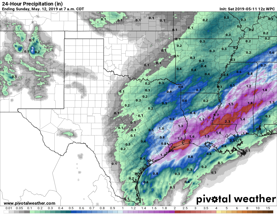
Showers and thunderstorms today will be driven by a disturbance moving up the Texas coast, combined with an extremely moist atmosphere. The best chance for storms today will occur south and east of I-69, near the coast. (Under some scenarios, the heaviest rainfall occurs near Galveston Bay, and under others, it occurs offshore). Generally, I think inland areas—those on the north and west side of I-69 will probably see about 1 inch of rain or less today, while people closer to the coast will see 1-2 inches. Isolated amounts of 3 inches or higher are, unfortunately, possible. The good news is that rainfall rates appear to be more restrained today, so we don’t anticipate any of the crazy 3+ inches per hour we saw over the last four days, which rapidly flooded streets.

NOAA rain accumulation forecast for Saturday. (Pivotal Weather)

Storms will likely develop between 10am and noon across Houston, with a general west to east motion that pushes them out of the metro area between 3pm and 7pm. Good riddance!

After this mess moves out, we should see clearing skies tonight, with rather pleasant weather for Sunday and Monday, with highs in the low 80s and overnight lows in the 60s. It will almost be nice enough for you to forget that June is only a couple of weeks away.