We are taking TS Laura very seriously, but its destiny is far from certain

Good afternoon. There’s a lot of ground to cover in this post, but we wanted to start with this: Tropical Storm Laura remains the region’s primary threat, and you really need to be paying attention. Today, you should be thinking about what you would do if a strong hurricane were to make landfall over the Houston-Galveston metro area on late on Wednesday or Thursday. Let us be clear: We are not saying that is going to happen. But it is well within the realm of possibility, and you should be thinking about what actions you would take, so that you are ready put them into play when the forecast tightens up.

Satellite overview at 2:15pm CT on Sunday. (NOAA)

For this post, we will discuss the forecast for Marco, briefly, and Laura. And we will also try to answer some of your basic questions about impacts, evacuations, and more.
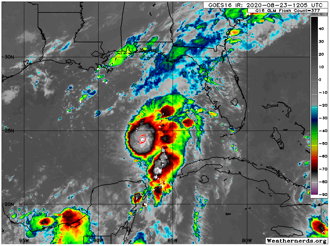
Hurricane Marco

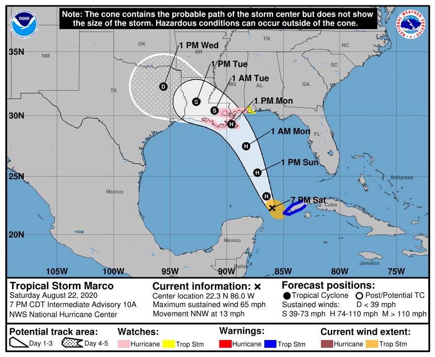
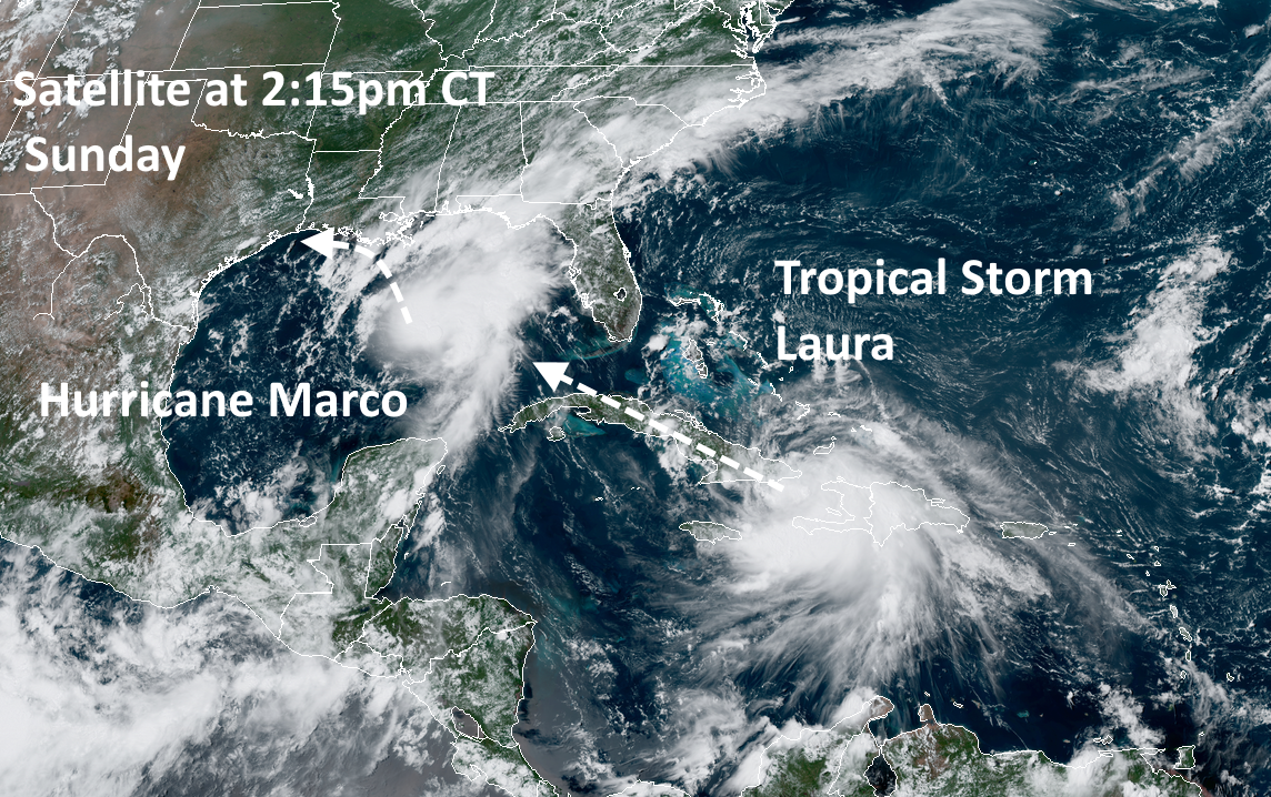
Marco became a hurricane today, with 75 mph winds. The storm is moving north-northwest at 14 mph, and this should bring its center very near the Louisiana coast by Monday evening. We still aren’t sure whether this storm will move all the way onshore Louisiana, or remain near the shore, and then start to fall apart as it tracks westward along the Louisiana coast toward Texas. However, because most of the winds and heavy rainfall should remain to the east and north of the center, we do not anticipate severe conditions in the Houston region from Marco.

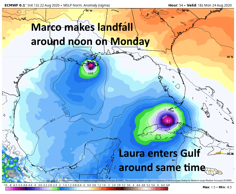
Probably the most significant thing about Marco now is that it seems plausible that the storm will slow down enough to potentially interact with Laura. This would not create some kind of “super storm” but may play some role in the track of Laura. Here’s one possibility:

Tropical Storm Laura

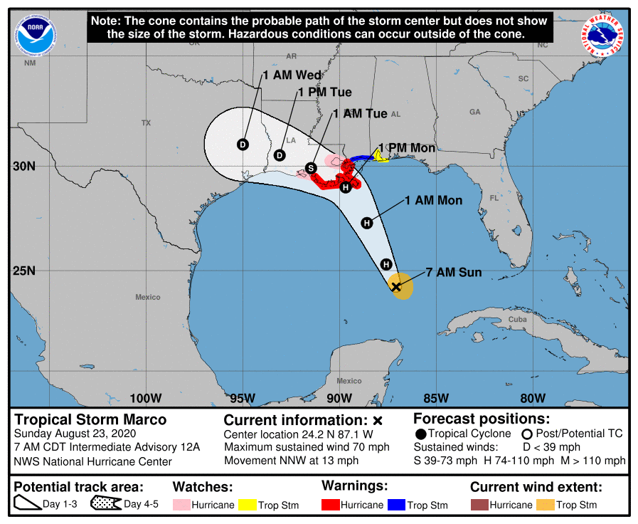
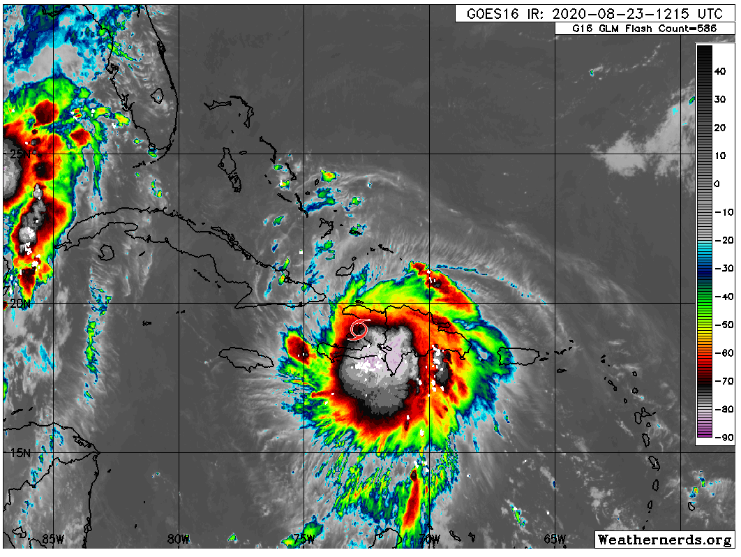
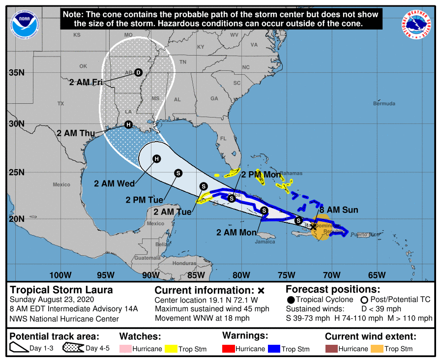
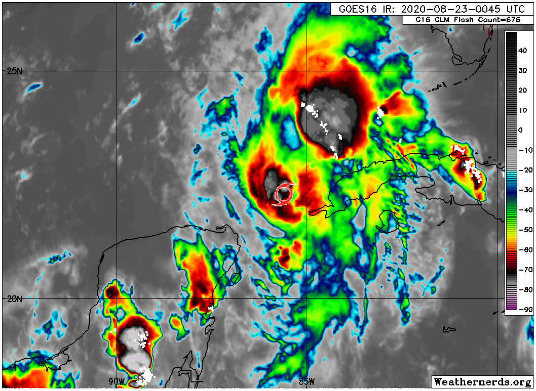
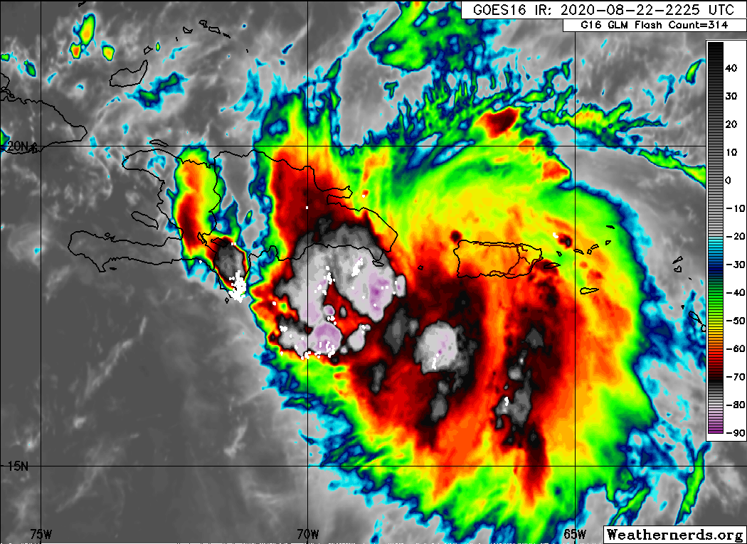
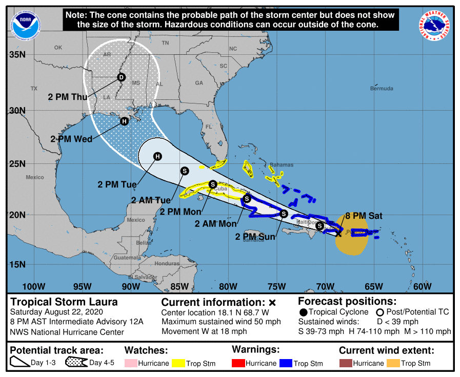
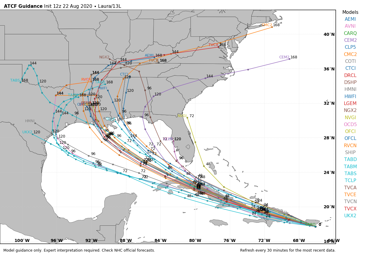
This system remains the key threat. Laura has moved across Hispaniola and maintained a reasonable structure. It will now spend Sunday night and most of Monday moving across Cuba before emerging into the Gulf of Mexico on Monday evening. Thereafter Laura will have 48 to 60 hours over warm waters, and an atmosphere favorable to intensification. It is reasonable to expect anything from a Category 1 to Category 4 hurricane to spin up on Tuesday or Wednesday over the open Gulf of Mexico. The situation is further complicated by Marco, which will not be all that far ahead of Laura, and the two systems may interact in ways that are difficult to predict even by the most sophisticated computer models in the world.

We simply have not received much clarity today in regard to a track forecast today. As a result, the National Hurricane Center’s 10am CT forecast track for Laura (shown below) is unlikely to shift much. Because of the broad uncertainty in the global model ensembles we are still reasonably looking at a track anywhere from Matagorda Bay, up through Houston, Beaumont, and across much of the Louisiana coast. For this reason, it’s probably not worth paying much attention to the “skinny black line” right now.

We don’t anticipate much shift in the official forecast track later today. (National Hurricane Center)

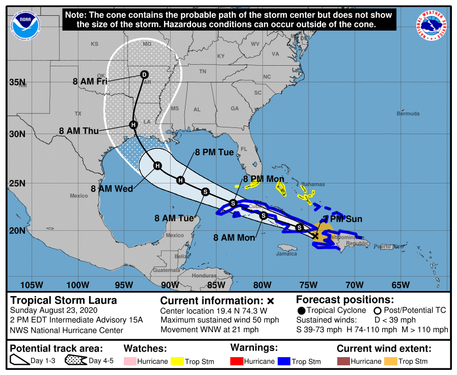
I think the hurricane center’s forecast is about as good as you could get considering all the uncertainties, but the bottom line is that this forecast can and probably will shift rapidly over the next day or so. Sorry, I know you want definitive answers. We don’t have them, and I wouldn’t trust anyone who says they do.

Alright, let’s get to some your most frequently asked questions below.

See full post

Marco on track to our east, but Laura’s forecast is inching farther west

Good morning. We’ll run down both storms this morning, though at a high level our concern and interest is primarily focused on Laura at this time.

Marco

Tropical Storm Marco continues to try and become a hurricane this morning in the Gulf.

Marco continues to lift NNW across the Gulf and is flirting with hurricane strength this morning. (Weathernerds.org)

Marco is expected to continue lifting just west of due north today, and it is aiming for a landfall somewhere in eastern Louisiana before making a fairly hard left turn and basically falling apart over southern Louisiana.

Marco is expected to come into eastern Louisiana, and it should then meander westward while significantly weakening. (NOAA)

We have seen a model or two bring the remnants more west along the coast, which would increase some storm chances for us and deliver some localized heavy rain on Tuesday, but right now those issues aren’t expected to be too serious.

Marco’s heaviest rainfall continues to look to stay well off to our east. Coastal areas may stand the chance for some locally heavy rain, but nothing serious expected right now. (Weather Bell)

Rainfall through Tuesday evening is expected to be mostly minor, with the best chance of something heavier along the immediate coast and lesser chances inland. The heaviest rain remains directed into eastern Louisiana.

The brief summary on Marco: Perhaps a small hurricane into southeast Louisiana before it dissipates while shuffling west across southern Louisiana, keeping most heavy rainfall well off to our east.

Laura

Tropical Storm Laura looks impressive this morning, mainly because it’s coming out of the typical nighttime peak in thunderstorms, and because it is doing this while interacting with Hispaniola, which often rips these things apart. Laura is the unfortunate one that actually gets by Hispaniola without a lot of trouble because it was disorganized to begin with.

Laura is not terribly strong this morning, but that has helped it begin to exit Hispaniola with an impressive area of thunderstorms. (Weathernerds.org)

If you want to provide some criticism of Laura, it’s that the storm is somewhat lopsided. But short of that it has a healthy core of storms, some developing outflow, and it is now exiting the highest hurdle it needed to survive, Hispaniola. Cuba comes next, but the bottom line here is that Laura has the skeleton it needs to become a healthy tropical system when it eventually finds a more hospitable environment for strengthening, likely Tuesday and Wednesday over the Gulf.

Laura’s track has shifted a little to the west since yesterday, but if you read between the lines in the National Hurricane Center’s discussion, there are likely to be more westward shifts to come.

Laura’s track is now shifting slowly to the west, and further shifts are possible if not likely today and tomorrow. (NOAA)

The battle lines right now are between some of the typical global models we use for day to day forecasting, which take Laura farther west, more into Texas and the tropical models we use for situations like this, which have skewed a little farther east, more into western Louisiana. Laura is going to basically work around the periphery of high pressure off to our north and east. Typically, we would expect the global models to have a better handle on the steering situation, so there is a reason to put some trust in them over the hurricane ones for track right now. Once Laura works across Cuba and emerges into the Gulf tomorrow, we will have a better idea of whether Corpus, Houston/Galveston, Port Arthur, or central/eastern Louisiana are most at risk. Right now, all we can tell you is that trends since yesterday have only served to give us more pause about how close Laura may come to southeast Texas. We continue to urge you to pay close attention to this storm and make your preparations today in case they need to be implemented quickly tomorrow and Tuesday.

How strong will Laura be when it gets where it’s going? That’s a great question, and right now, the reliable model intensity guidance ranges from a low-end category 1 storm to a high-end category 3 storm. Given the history of the Gulf, the fact that it’s going to be in a fairly favorable environment for strengthening, and frankly how it has performed so far, we would likely lean toward the higher end of things with respect to intensity right now. The NHC forecast is calling for a category 2 hurricane at max, which is right in the middle of reliable guidance at this time. Hurricane intensity remains a very, very difficult thing to predict and though we are bullish on this storm’s strength right now, there are still risks equally spread that we may be too aggressive or not aggressive enough. More clarity on this should come tomorrow.

As far as rainfall goes? That is always a concern, but Laura is expected to keep moving and no models indicate a slowing or stalling. For all intents and purposes, we are viewing this a tropical threat (storm surge, wind) first and foremost and a rainfall flooding threat secondarily. Again, please stay aware and ready to act.

Eric will have our next update posted no later than 3 PM today.

Marco enters the Gulf as Laura lumbers across Hispaniola

Good evening. Eric’s update from this afternoon has most of the situation covered. I’m here to just refresh what’s going on, and I also want to talk a little bit about Laura.

Marco

As of this evening, Marco has moved past the Yucatan channel and into the southern Gulf of Mexico.

Marco has moved into the Gulf this evening as a 65 mph tropical storm, although most of its storms and winds are north and east of the center. (Weathernerds.org)

Marco still has maximum sustained winds of 65 mph and is still moving just slightly west of due north around 10 to 15 mph. I put a tropical storm icon on the satellite image above to indicate where Marco was located. It’s worth noting how lopsided Marco’s thunderstorms are, with basically everything north and east of the center. This has implications on the rainfall forecast for Marco after landfall.

There has been little to no change in terms of expected track with Marco relative to what we thought most of the day.

Marco should roughly track toward eastern Louisiana, possibly becoming a hurricane and maintaining low-end hurricane intensity up to landfall. (NOAA)

The National Hurricane Center’s forecast track takes Marco broadly toward eastern Louisiana. The storm is expected to become a hurricane, and it could maintain hurricane intensity up to landfall. Marco is compact, so any hurricane-force winds will only extend out a few miles from the center, mainly to the east of where it tracks.

As far as rainfall goes, we feel the bulk of it will end up well into Louisiana, Mississippi, and Alabama. The map of rainfall below (through Tuesday evening) will look a little odd because it’s a composite of various National Weather Service offices putting together their own forecasts, so some may be older or newer and not smoothed out. But it shows that the heaviest rain is expected to be closer to New Orleans than Houston.

Rainfall from Marco is expected to be heaviest well to the east of Houston, deep into Louisiana. (Weather Bell)

If for some reason Marco starts to weaken tonight and ends up falling into disarray tomorrow, there is some chance it could drift back west of the forecast cone. We feel that possibility is highly unlikely however, and we are not going to worry about significant rainfall from Marco in our area. Marco should fall apart after coming onshore, drifting into northwest Louisiana, Arkansas, or northeast Texas as a remnant low with isolated pockets of heavy rainfall. We should be able to close the books on Marco by Tuesday night or Wednesday morning.

Laura

Let’s talk about Tropical Storm Laura. I’m going to be really honest about this one: We do not know who is most likely to see landfall from Laura when it gets to the Gulf. There is a plausible risk that it could go toward the Florida Panhandle, the central Gulf, Louisiana, southeast Texas, or even Matagorda, Corpus Christi, or Brownsville. So quite literally no one (save maybe the Florida Peninsula) can let their guard down with respect to Laura. We really want folks in Southeast Texas to be prepared in case this does come this way. There will likely be some element of “Well, y’all were fired up about Marco and look what it’s gonna do” from some people out there. With Marco, we laid out scenarios because we knew there was no answer key (til today). With Laura, we’re in that same scenario phase right now, and there is no clear model or forecast that is able to see Laura’s future clearly at this point.

We have laid out some of the factors involved with Laura’s interaction with Hispaniola through the day today. As of this evening, it appears Laura may be choosing to set itself up on the south side of Hispaniola.

A satellite loop of Laura this evening shows a lot of storms but weak organization with a loose center on the south side of Hispaniola. (Weathernerds.org)

This and other such interactions with Hispaniola and Cuba are critical to Laura’s future. They are also unpredictable. The current NHC forecast takes Laura generally off to the west or west-northwest.

Laura’s NHC forecast takes it into the Gulf as a hurricane, with a turn north somewhere in the western Gulf, with areas from Texas through the Florida Panhandle still in the cone. (NOAA)

But each shift like this, with a center possibly forming farther south keeps the storm disorganized and following the bottom or left side of the cone.

The rule of thumb: As with Marco, the weaker the storm is, the more likely it will come farther west before turning northward. So if Laura continues to struggle in the islands and remains weak, there’s a pretty good chance it will follow the bottom of the cone more than the top of it, which puts it farther south to start in the Gulf and gives it a much easier route to get as far west as Texas. A stronger storm will be more apt to lurch poleward and help limit the impact of high pressure over the Southeast, meaning it would likely turn well before it gets to Texas, either near Louisiana or east of there. As of Saturday evening the weaker option is winning out, which is why it’s important to continue to stay tuned in tomorrow and Monday. We are going to still have questions tomorrow, but I predict that by Monday, we’re going to have a good idea if this is an ominous threat to Texas or another miss to our east. Stay tuned.

Our next update will be posted no later than 9 AM on Sunday.

Marco likely to go east of Houston, still lots of questions about Laura

Good afternoon. We’re finally starting to get a better handle on what is likely to happen with Tropical Storm Marco today, which is a good thing because the storm may make landfall as soon as Monday along the northern Gulf Coast. We have less certainty about Tropical Storm Laura, which is a cyclone most of the Gulf Coast needs to continue to watch.

Tropical Storm Marco

Marco has done two things today that increase our confidence that it will follow a more northerly track across the Gulf of Mexico. For one, it has continued to intensify, up to 65 mph sustained winds as of 1pm CT, allowing it more control over its track. Second, an Air Force reconnaissance plane found a center east of where it was expected. All of this suggests the storm will track more toward Louisiana rather than Texas over the next two days—if you read our early morning post on Space City Weather, this was Scenario One that we outlined.

12Z European model forecast for Marco and Laura as of Monday, 1pm CT. (Weather Bell)

While we cannot rule out a more westward track toward Texas (and of course, we’ll continue to monitor the system), at this point it appears most likely that Marco will come ashore over Louisiana, or even Mississippi. Because we can expect the strongest winds, waves, and rains to the east of the land-falling center, this means the most likely outcome for Houston is moderate to minimal effects. The northern Gulf of Mexico coast will need to watch Marco closely over the next couple of days. Although Marco now seems likely to become at least a moderate hurricane, it should encounter enough wind shear to weaken to a tropical storm before landfall a couple of days from now.

Tropical Storm Laura

This system has strengthened some today as its center has become a little better defined. Shortly before 1pm CT, the center was located just offshore the southern coast of Puerto Rico, and it may briefly come ashore later today. In this morning’s post we outlined some of the factors surrounding Laura’s potential to intensify over the next day or two as it encounters Puerto Rico, Hispaniola, and Cuba (i.e. to shred, or not to shred). From this image you can see how predicting this is touch-and-go.

Center of Tropical Storm Laura shortly before 1pm CT Saturday. (RadarScope)

Because we don’t know precisely how much time the storm will spend over this at-times mountainous terrain, there’s not a whole lot intelligible we can say about Laura’s intensity upon entering the Gulf of Mexico on Monday. However, assuming some semblance of a circulation remains by then, conditions in the central Gulf of Mexico would allow Laura to strengthen, quite possibly into a hurricane.

Don’t trust spaghetti plots! But in this case, this provides a nice illustration that there are a broad range of possibilities for Laura. (Weather Bell)

We still have lots of questions about Laura’s track after reaching the Gulf. The storm seems eventually destined for Louisiana or Texas, but it could come as far east as the Florida Panhandle. If anything, the models this afternoon are leaning ever-so-slightly toward Louisiana over Texas, but we’ve seen plenty of flip-flops so our confidence is quite low. If Laura were to come to Texas, we probably would begin to see its effects by Wednesday night or Thursday.

ON THE BRIGHTER SIDE: I think we’ll have a better handle on Laura’s track over the next 24 to 36 hours, which should still allow several days for final storm preparations—if needed. So as usual, we’re asking you to hang in there with us for a little while longer. And if we can get through Laura, it looks like the tropics may quiet down for a bit, allowing all of us to take a breath.

Matt will have our next update, no later than 9pm CT Saturday.