A couple more nice days before a tricky Mother’s Day forecast

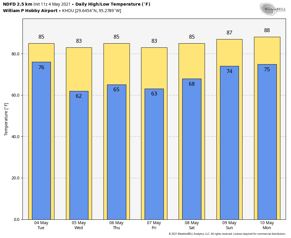
We managed the mid-80s yesterday with dew points sitting in the 50s all day, which is pretty comfortable. We get another day or two of that kind of weather before things go back to pre-summer and the details of the forecast get more complicated.

Today and Friday

Look for lots of sunshine and just a few clouds both today and tomorrow. A little low cloud cover or patchy fog is possible tomorrow morning southwest of Houston. We should manage mid-80s both afternoons and upper-50s to mid-60s tomorrow morning, similar to today. Galveston should bottom out near 70° tonight, however. No weather woes, but air quality may be poor. You may have seen the Ozone or Air Quality alerts on your phone or other sites you use for weather info. Having a lot of sunshine, warm temperatures, and light winds tends to help produce ground-level ozone in areas with pollution from heavy traffic and industry. Days like this in spring, summer, and early fall are not uncommon here unfortunately. Take it easy if you have any respiratory sensitivities.

Saturday

Humidity will still be low enough on Saturday morning to allow temperatures to drop perhaps into the low to mid-60s away from the bays and coast. But as Saturday progresses, the humidity will inch upward. Look for highs in the 80s, some sunshine and added clouds, and a very slight shower chance. Saturday night will see temperatures struggle to get below the low-70s, so “pre-summer” will be in full effect.

Mother’s Day

The forecast gets conveniently complicated beginning on Sunday unfortunately. The setup for Sunday and much of next week is going to be contingent on the exact placement of a cold front that is destined to stall out somewhere between the Gulf Coast and Dallas. This will likely lead to at least a couple rounds of thunderstorms, with the first occurring Sunday afternoon. Models still have some disagreements on coverage, intensity, and the exact location of Sunday’s storm chances, however.

The European and GFS models both show higher rain risks north of Houston on Sunday, but the Euro has a much more robust area of thunderstorm coverage than the GFS at this time. Details TBD. (Weather Bell)

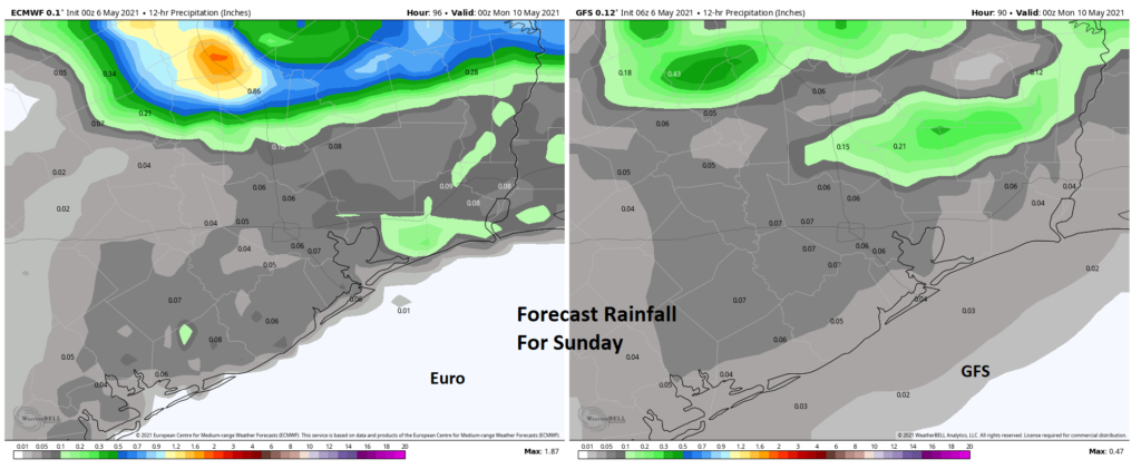
The odds of more widespread showers and storms on Mother’s Day are still highest right now north of Houston. But there is little room for error in that current forecast, meaning any shift south will open the door to greater coverage of afternoon storms in and around Houston. The timing may allow for Mother’s Day brunch plans to go off successfully (though there will likely be at least a few showers around late Sunday morning into early afternoon). But those of you with Mother’s Day dinner plans, particularly outside, will want to keep tabs on the forecast.

Look for highs well into the 80s, though any thunderstorms will allow temperatures to briefly cool off.

Next week

As noted above, next week’s forecast will be highly contingent on exactly where that cold front orients and the timing of any disturbances rippling along the front. Expect at least a chance of storms Monday through Wednesday, but trying to hone in on exact details on timing and intensity this far in advance is very difficult. We will know more as we get closer. Look for highs in the 80s to near 90 degrees at times, lows in the 70s.

Another front?

By later next week, the European ensemble, which runs slightly tweaked versions of the European model 51 different times is showing about a 60 to 70 percent chance that the front responsible for next week’s unsettled start will slip through the region and offshore.

There is a better than average chance that another brief period of comfortable air may arrive for a couple mornings later next week. (Weather Bell)

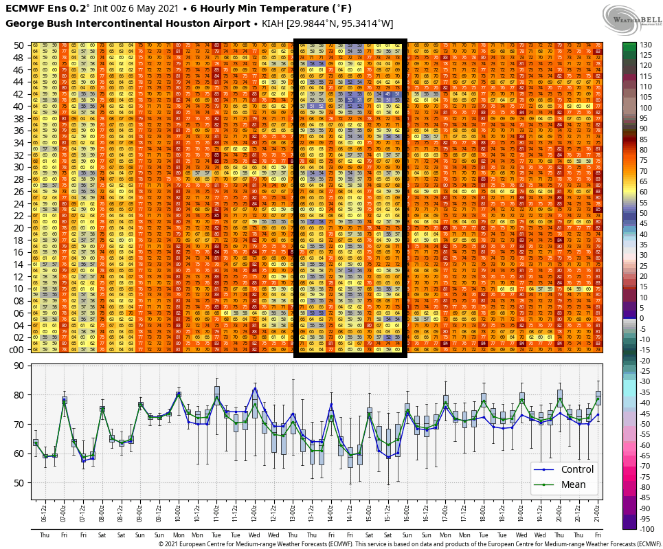
You can really only see this reflected in overnight lows, which noticeably drop back on the ensemble (boxed in above) beginning Thursday or Friday morning. It’s worth noting that the GFS model is somewhat less enthusiastic about this possibility. So, there is still some uncertainty here, but if we do see the front clear us next week, look for highs to drop back a few degrees into the low to mid-80s and morning lows to go from the 70s early in the week to mid to upper-60s perhaps, with some risk for slightly cooler. We will see!

Houston’s new climate normals: Warmer & wetter

With a fine, quiet stretch of weather beginning today for Houston, Eric and I thought it would be a good time to write a bit about the new climate normals released by NOAA on Monday night. When we compare weather to “normal” or “average,” these are the values we are comparing to, so it is useful to understand how they will be changing.

What are they? Every 10 years, NOAA and the National Weather Service, along with other government weather agencies around the globe recalculate what the typical weather has been like in the previous 30 years. Think of it like the Census, but for weather.

Why average 30 years of weather instead of, say, 50 or something? First off, the World Meteorological Organization (WMO), which is essentially the U.N. for meteorological agencies stipulates that member states use a 30 year standard. In general, 30 years is enough data to get you a good snapshot of what the current climate is, rather than a 50 or 100 year average. In other words, when we compare weather to a 30-year normal by saying something like, “Today was 15 degrees warmer than normal,” we’re comparing to the shorter-term climate we’re used to, not the one perhaps our grandparents lived through. And 30 values is generally when statistical averages become more reliable. Some users and industries prefer their “normal” to be calculated over a different timespan, so those calculations will be added to the mix from NOAA as well.

Why do they matter? When dealing with weather and making plans in business or designing buildings or planting crops, you need to have a baseline to anchor yourself to, some kind of “average” weather. Imperfect as they may be, the 30-year normals accomplish that. Having those allows us to explain weather in terms of how typical or atypical it is on a particular day or in a particular month. One thing we all know: Weather changes and can be wild, and “normal” is really just an average of a bunch of various extremes. But we need to have that anchor point to describe weather in a climatological context. I don’t know if this is originally attributable to him, but as Dr. J. Marshall Shepherd, former president of the American Meteorological Society likes to say: “Weather is your mood and climate is your personality.” It’s good to know a local area’s “personality!”

So what has changed? Let’s start big and then go small. Across the U.S., the new set of climatological normals is generally warmer, much warmer. The only areas cooler than the previous set of normals were in the Plains.

The new set of normal temperatures was warmer everywhere except primarily in parts of the Plains. (NOAA)

Officially, Houston’s annual average temperature (at IAH Bush Airport) rose by 0.7° versus the previous normal. At Hobby Airport that change was 1.0° warmer, and at Galveston it was 1.1° warmer.

Houston (IAH) officially warmed in every month except November and December. (NWS Houston)

The only months that showed cooling relative to the previous set of normals were November and December. Summers have warmed by a bit over a half-degree on average, and late winters have warmed by over 1 degree. Some other notes: Our first day with an “average” high of 90° has moved up to May 29th from June 3rd. Our last day of average highs of 90° or better is September 18th, up from the 14th. So, we’ve added roughly a week more of days with an average high of 90° in 1991-2020 versus 1981-2010. Additionally our hottest daily average maximum temperature (or “peak” of summer) is up to 95.7° compared to 95.0° in the previous set of normals. Not only that, that peak has moved up a bit to August 4-6 versus a longer, flatter peak from August 5-12 previously. I wouldn’t read too much into that last part, but it’s something to note at least.

You’ll also notice that rainfall has increased, thanks in part to average August rainfall being over 1 inch wetter than in the prior normals. This is almost certainly thanks mostly to Hurricane Harvey. Houston now sees rainfall of roughly 2 inches more than we used to each year.

Galveston was significantly warmer compared to the previous iteration of normal, especially at night. And rainfall was substantially lower. (NWS Houston)

Interestingly, but perhaps not surprisingly to some folks if they live there, Galveston actually saw annual average rainfall decrease in this latest set of normals. In fact, not only does Galveston see less rain now on average, it’s over 3 and a half inches less! This is likely both a function of randomness in the sporadic nature of daily thunderstorms here but also a notable change related to <waves hands> something with respect to the warming water temperatures of the Gulf of Mexico or more frequent ridging in the upper atmosphere over the Southeast. This feels like too big a change to me to be just random chance. In addition, Galveston was substantially warmer, especially during nighttime. Average lows are over 1.5° warmer now than they used to be.

Anyway, hopefully you find this interesting. How we describe weather “relative to normal” will change going forward, so we feel it’s notable to explain to you how that will change. On to the forecast.

Today through Friday

Step outside this morning, folks.

We have temperatures in the 50s inland to low or mid-60s in the city and along the coast. And the humidity has plummeted. Look for plenty of sunshine and highs around 80° or in the low-80s this afternoon. Tomorrow looks just as nice. Expect morning lows in the 50s north and west of Houston and low or mid-60s in the city and along the bay. Galveston should see upper-60s. Another day of sunshine will allow us to get into the mid-80s tomorrow. Friday looks like essentially a carbon copy of Thursday with a few added higher clouds at times.

Saturday and Sunday

Look for onshore flow to kick back in this weekend, driving our dew point temperatures back up to 70° or so, along with highs well into the 80s. Saturday morning will probably see 60s for lows, while Sunday should see 70s in the morning. Along with that, there is at least a chance of a shower or storm Saturday. For Mother’s Day, we expect a slightly better chance of showers, however despite being better, those chances still remain fairly low right now in most of the Houston area. As you go north of Highway 105, the chance for some more robust rain and storms may increase somewhat. We’ll hone in on details more tomorrow and Friday.

Next week

It’s too early to get too into the weeds next week, but with a cold front “in the neighborhood,” suffice to say it will probably be a somewhat unsettled period ahead. More on this for you tomorrow and Friday as well.

Summer unofficially began on Monday

Well, it had to happen eventually. On Monday the high temperature at Bush Intercontinental Airport, the city’s official weather station, hit 90 degrees. For me, this represents the beginning of summer, at least psychologically. Thankfully, since this is May, we’ll probably still see a couple of more moderate fronts to bring some drier air into the region, including one later today. In terms of climatology, on average, the city’s first 90-degree day comes around the beginning of May, so we’re right on schedule this year.

Tuesday

The aforementioned front will arrive in central Houston around noon, and should push off the coast during the late afternoon hours. A broken line of showers and thunderstorms will accompany the front, and some of these could be briefly intense. However, the dynamics for stronger storms are much more favorable to our east, over Louisiana. Probably about half of the Houston region will see rain, with totals of one to two tenths of an inch of rain for most.

NOAA severe storm forecast for Tuesday and Tuesday night. (NOAA)

After highs reach the mid-80s, beneath mostly cloudy skies today, lows will drop into the low 60s overnight. Winds will blow out of the north at about 10 mph overnight, continuing to bring drier air into the region.

Wednesday, Thursday, and Friday

As high pressure settles over the upper Texas Gulf coast we will see a string of mostly sunny days with pleasantly dry air. Look for highs in the mid-80s, and lows generally in the 60s. These will be mornings and evenings to really savor the outdoors.

Saturday, Sunday, and beyond

The onshore flow will resume this weekend, but right now the most likely outcome will simply be an uptick in cloud cover, rather than any meaningful rain chances. Highs will depend on how much sunshine breaks through, but I suspect both days will likely reach the upper 80s, with warm nights.

Those cool nights won’t last, Houston. (Weather Bell)

Beyond the weekend the forecast may see additional warming—back to the 90s, perhaps?—into Monday and Tuesday. Rain chances start to tick up by Tuesday or so, but there’s no clear signal in the models for what that really means other than departing high pressure will make the atmosphere less stable.

Looking back at our recent rains, ahead at a lovely May week

Before jumping into the forecast for the week ahead, I want to look back at the heavy rains the region received—or in some cases did not receive—to illustrate the perils of Gulf coast precipitation prediction. As you may recall, we predicted widespread variations in rain totals, but said some areas faced a Stage 2 flood alert on our scale. This essentially means we thought parts of Houston would see flash flooding, with mostly localized effects. With that in mind, here are the three-day rainfall totals from the storms:

Houston area three-day rain totals. (NOAA)

The first thing I notice on the rainfall map is an extremely tight rainfall gradient. Essentially, if you lived southeast or east of Houston outside the Sam Houston Tollway you saw 2 inches of rain, or less. You might have wondered what the fuss was about with our flood scale. By contrast, a mere 50 miles away, a large swath from Lake Jackson to Sugar Land saw 6 to 12 inches of rainfall. This would have caused significant flooding problems had it set up just a little bit to the northeast, over the metro Houston area. Anyway, in the end, our forecast was pretty good. But if you lived in Galveston, you probably thought we oversold the event. And if you live in Needville, perhaps we undersold it. This is why flood forecasting is extremely difficult across such a large area.

Overall, despite the dreary Saturday that cost many of you weekend plans, this was a beneficial event. We had a dry spring across the region and are about the enter a period of time when 90-degree days are common, and soils dry out more quickly. Before this weekend’s rain, some southern parts of our region were already in an extreme drought (see map below), with large swaths north and south of Harris County in a severe drought. These rains will take a bite out of that drought.

Texas drought conditions as of April 27, 2021. (U.S. Drought Monitor)

Ok, now that the rains have passed, and we’ve talked a bit about them, let’s jump into the forecast for the week ahead. All in all, it’s pretty nice for the first week of May.

Monday

Today will be a warm one, especially if this morning’s widespread clouds break and skies clear a bit this afternoon. High temperatures have yet to officially reach 90 degrees this year, but could do so this afternoon at Bush Intercontinental Airport as warm air moves in from the Gulf of Mexico. Southerly winds will gust up to 20 mph. Monday night will be warm again, with lows in the 70s and high dewpoints.

Tuesday

A modest front will arrive on Tuesday to bring some relief. It looks like a broken line of showers and thunderstorms will accompany the front’s passage, but rain accumulations overall look fairly slight. The front should reach the central part of the region by around noon, and push off the coast during the afternoon. Winds will turn northerly in the wake of the front, with lows dropping into the 60s Tuesday night.

High temperatures Monday will be very warm, especially inland. (Weather Bell)

Wednesday, Thursday, and Friday

It’s May, so our weather is not going to become cold after this front passes. But we should see a nice influx of dry air to make for a pleasant end of the week. These three days will likely be mostly sunny, with highs in the low 80s, and lows in the low- to mid-60s, generally. Enjoy the dry air, as there won’t be all that much of it left before summer arrives.

Saturday and Sunday

A returning southerly flow should make for a warmer weekend, with skies turning partly to perhaps mostly cloudy. Highs will likely return to the mid- to upper-80s with some slight rain chances. This should set the stage for even warmer conditions next week.