Thanksgiving travel still looks mostly uneventful

Well, we sure didn’t start the holiday week on a bright and cheerful note, as Monday was a December or January-like gray Southeast Texas day. We will have a much brighter day today before we head into the holiday weekend with some low-impact unsettled weather to discuss post-Thanksgiving.

Today & tonight

Skies have mostly cleared out across the area, with the exception of a few spots south of I-10, as of about 5:30 AM. Expect those locations to clear out also, and we’ll have a mix of sun and just a few clouds in the area today. It will feel world’s warmer versus yesterday. Monday struggled to hit 50°, but today we should have no issues getting into the low-60s for high temperatures. Clear skies will continue tonight. Look for overnight lows to range from the low-40s northwest of Houston to the mid-40s in Houston and the upper-40s southeast of town.

Wednesday

The good news: If you’re traveling around the region on Wednesday, it should be mostly uneventful. There will be some low clouds or light rain and drizzle that materializes in the afternoon, mainly in East Texas. So just be prepared for some wet roads if traveling anywhere from Houston late. But any meaningfully significant rain will develop overnight and mainly over the open offshore waters of the Gulf of Mexico or east into Louisiana.

If you’ll be traveling outside of the region on Wednesday, there shouldn’t be a ton of issues to deal with.

If you’re travelling nationally, there should not be serious issues outside of a couple spots. The Northeast will see some snow showers with breezy conditions, while a major storm will impact the West Coast. (NWS/WPC)

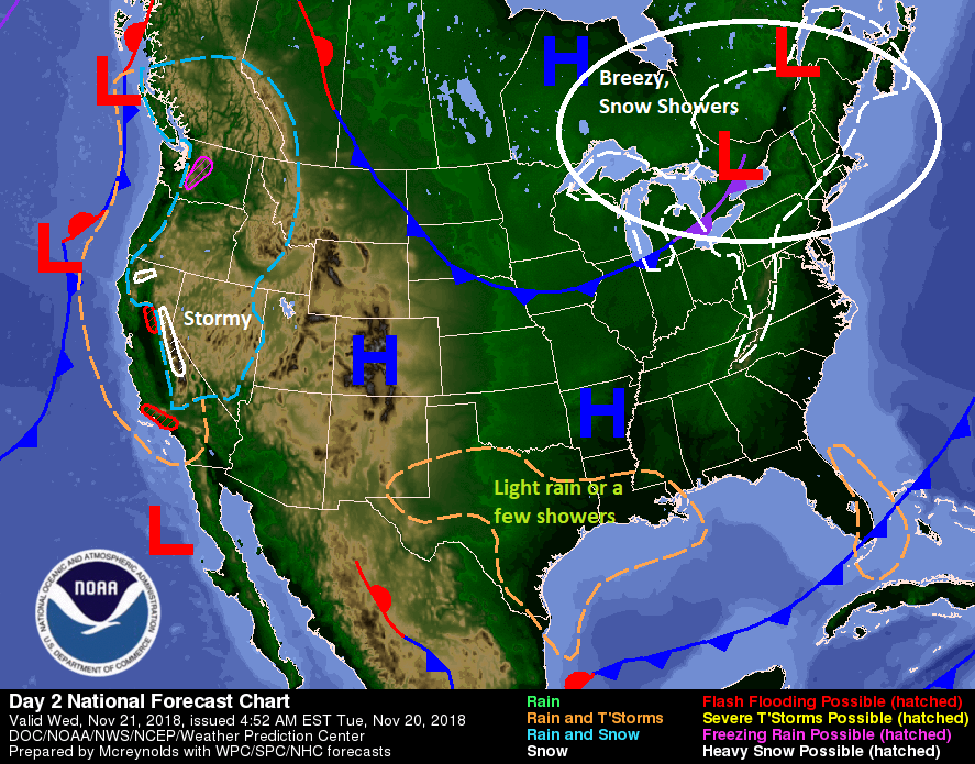
There will be snow showers and some gusty winds in the Northeast, so if you’re flying toward New England or the New York City airports, that could give you a delay. Atlanta and Chicago both look good Wednesday, so a couple trouble-free hubs will help matters. There will be no issues in Denver, but a storm bringing much needed rains to California may cause some issues at San Francisco or Sacramento. Overall, this is an acceptable travel day forecast.

Bringing it back locally, we’ll see clouds gradually increase during the daytime. Some light rain, drizzle, or a few showers may develop toward evening and that would continue into Wednesday night.

See full post

Warmer weekend, wetter weather on the horizon

Yesterday ended up being a nice day after another cold morning. I wanted to highlight a couple superlatives from yesterday. At Bush Airport, we snuck down to 30°, once again, our coldest morning this early in the season since 1999 (11/3/1999). That’s our official tally for the date. Impressively, Hobby Airport got down to 32° on Thursday morning. It hasn’t been that cold this early in the year since 1969, when we hit 28° on November 15th!

So for the greater Houston area, it was our earliest freeze in about 20 years, though for a few parts of the area, it was likely our earliest freeze in almost 50 years!

No more freezing temperatures to discuss for a little while, but we will be discussing some more active weather once again.

Today and Saturday

Other than some passing high clouds perhaps, today looks great. Spectacular, even. We’ll warm up into the middle or upper-60s in most of the area. A few spots could push 70 degrees. We added about eight to ten degrees to morning lows today, and I expect we’ll add another six to eight degrees on Saturday morning. Most folks will sneak into the mid-to upper-40s tonight, though a few locations may neglect to drop below 50 degrees.

During the day Saturday, we should see a few clouds rolling back into the area. So we’ll call it partly to mostly sunny. We should be able to hit or exceed 70 degrees on Saturday afternoon.

See full post

Soggy Friday sweeps autumn back into Southeast Texas

Good morning, and it’s a soggy one. This won’t herald a total washout this weekend, but it has brought autumn back to the region after a mostly summery week.

Today

Right off the bat, radar as of about 5:15 this morning shows numerous showers and embedded thunderstorms working across the region.

Radar shows a busy morning in the clouds with widespread rain and thunderstorms. (College of DuPage)

Expect off and on rain to continue all morning, gradually slowing down and becoming more infrequent this afternoon. We should dry out tonight.

The rain is actually occurring behind a cold front that has basically pushed through everywhere as of 5:15 AM.

Temperatures have fallen into the 50s almost everywhere already. They won’t get much higher than this for the rest of the day. (NWS)

Just about all of us are in the 50s now, and don’t expect it to get much warmer. We will probably drop another few degrees this morning before stabilizing this afternoon. By tonight, those temperatures will settle into the upper-40s to around 50 degrees.

It will also be breezy at times today, with a steady north wind around 15 mph, but higher along the coast and Galveston Bay where wind advisories have been hoisted.

Weekend

Saturday should be a bit of a gloomy looking day, but I don’t believe it will be a day where you need to adjust many plans. Look for a mix of clouds and a little sun. In the afternoon, there could be a few showers around. With a dry atmosphere, it would be unlikely that much of the moisture survives the trip from the clouds to the ground. I think the best chance for real showers or some rain to occur would be along the coast by later Saturday afternoon.

On Saturday night, expect a weak system to begin to organize offshore of Galveston. This will spread scattered showers and a chance of thunderstorms into Southeast Texas overnight and during the day Sunday. I don’t think Sunday will be a washout for everyone, but I do think most of us will see at least some rain. Near the coast, it could be heavy at times.

Total rainfall on Sunday and Sunday night should tally a quarter to a half-inch, with some coastal or far inland locales possibly seeing higher amounts. (NWS via Weather Bell)

All told, we should see another quarter to half-inch or so of rainfall, with isolated higher amounts likely, especially on the coast or well north and east of Houston. Temperatures will top off in the mid-50s on Saturday afternoon. They shouldn’t drop much below the upper-40s on Saturday night, and they likely won’t get past the mid-50s in most spots Sunday afternoon as well.

See full post

Cooler weather coming after one of Houston’s warmest November days

Hi all. You get Matt the next couple days. I just want to remind y’all about our annual fundraiser that’s underway through later this month. We have two cool t-shirt designs and umbrellas available to purchase if you’d like. The annual fundraiser helps support Eric and myself and our work keeping the site on time and online. Regardless, we appreciate your kind words and support throughout the year, and we are thrilled you choose us as a vehicle to stay informed.

On to the weather, and someone has to congratulate you for surviving the hottest November day on record in Houston. We hit 89° on Wednesday, which matches, with 9 other days, the hottest November maximum temperature on record in the city of Houston. The last time we hit 89 in November? Way back on November 6th of 2017. Almost a year to the day. The latest in November we’ve hit 89° would be on November 8th, done in back to back years of 1988 and 1989.

If you’re sick of the warm, ridiculously humid weather, we have good news. The end is pretty much here. Let’s walk through the forecast.

Today

We had quite the light show last night over parts of the Houston area.

In fact, some areas did receive over two inches of rain from the storms yesterday evening.

Total rainfall in the last 24 hours exceeded 2 inches near Tomball, The Woodlands, and in parts of northwest Houston. (Harris County FWS)

Some locally heavy rains also fell south of Houston. With the exception of a handful of remaining showers, it’s now quiet this morning. The cold front responsible for last night’s noisy storms is now sitting offshore. It’s still a bit humid, so southern parts of our area will have patchy dense fog to deal with this morning.

Otherwise, I would expect a good bit of cloud cover today, along with a chance for some lighter rain, drizzle, or showers at times. No serious weather is expected though. It will be noticeably cooler today with high temperatures probably not getting much past the low-70s in Houston. Areas south of Houston could still push mid-to upper-70s however.

Tonight & Friday

The next cold front arrives in the Houston area tonight. As it does so, expect showers and some embedded stronger thunderstorms to accompany it on its move south. The front should arrive in the far northern suburbs around midnight, give or take a couple hours, into the Houston area after 1-3 AM, and to the coast after 3-5 AM. Unlike our cold front last week, this edition will not come with a sharp, quick clearing line. In fact, the atmosphere behind tonight’s front will remain chilly, cloudy, and damp into much of Friday. Expect showers, perhaps a thunderstorm, and periods of light rain or drizzle along with a stiff north breeze during the day Friday. We should see around one to two inches of additional rainfall with this front.

Temperatures will remain mired in the 50s most of the day. Rain chances should dwindle as we get toward evening.

See full post