We’ll be starting off the Christmas period with a bang today and tomorrow before some clouds build in for the holiday, followed by a potentially active period of weather later next week. Let’s dive into the details.
Today & Saturday
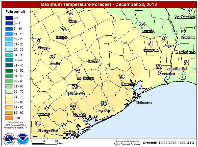
As we officially begin winter at 4:23 PM today, the season kicks off on a beautiful note. We had lots of wind yesterday, but most of that is gone now, and we’ll see sunshine with mid-60s this afternoon. A cool, crisp night in the low- to mid-40s will follow tonight. Look for essentially a repeat of Friday on Saturday, along with several degrees of added temperature. We’ll do mid-70s on Saturday under sunny skies.
It may be a bit warm for December, but it will really be a nice day Saturday. (NWS Houston)
It should be a stunner.
Sunday
A weak cold front will approach the area on Sunday morning and afternoon. After starting the day in the milder mid-50s, we should see our afternoon capped in the mid- or upper-60s. Sunday will probably have a few more clouds at times, though I think we will still see majority sunshine. A stray shower can’t be ruled out with the front, but most folks should stay dry. Some patchy fog is possible around Galveston Bay or on Galveston Island Sunday morning.
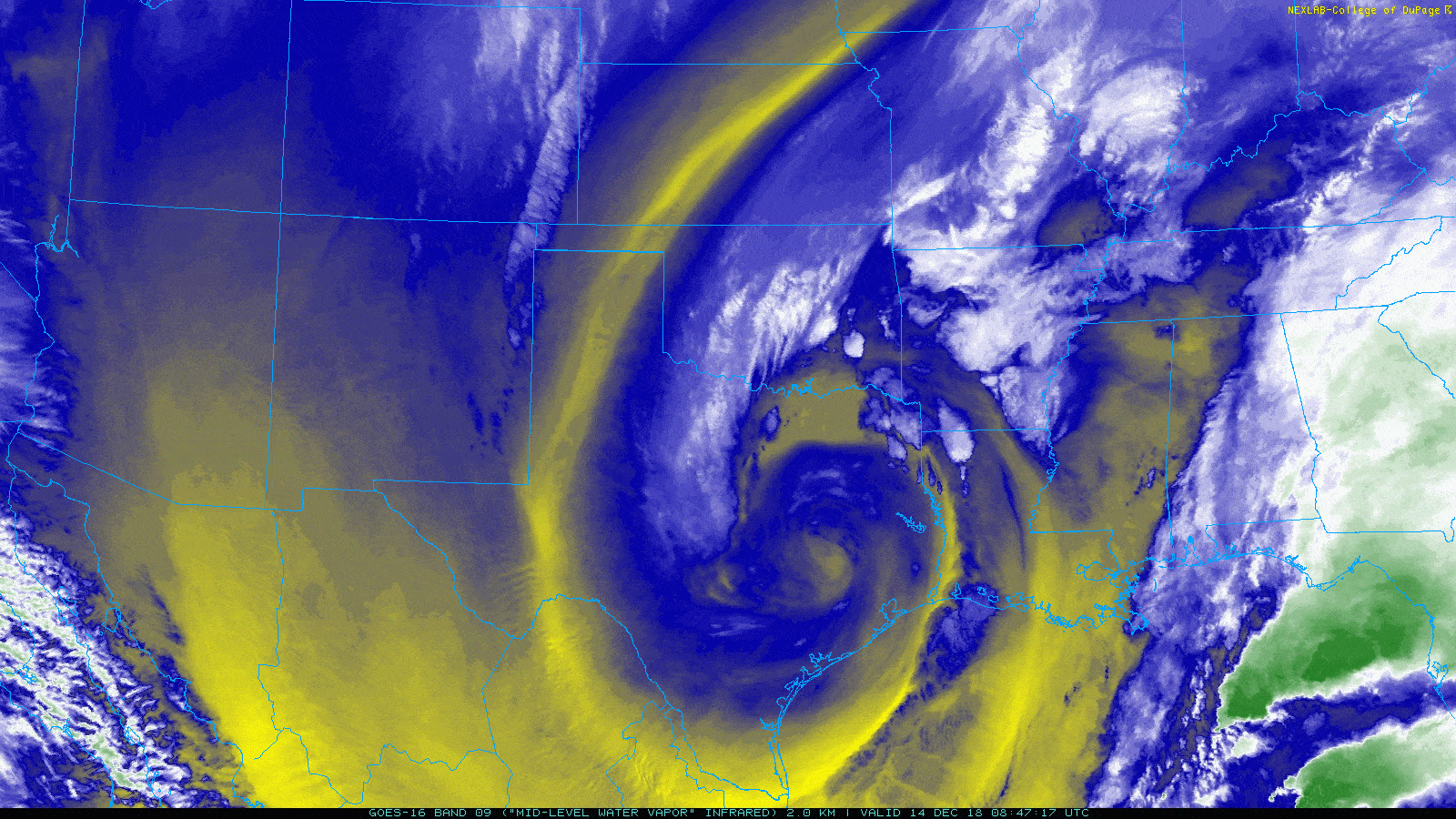
Let’s start off this morning by taking a look at the satellite imagery over Texas.
Water vapor satellite imagery shows an impressive storm system in the upper atmosphere rolling across East Texas this morning. (College of DuPage)
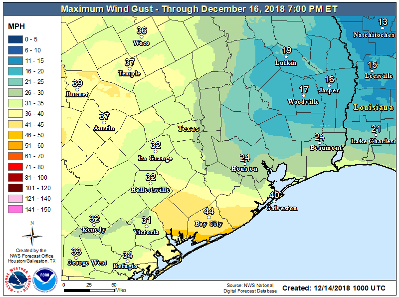
You don’t often see such an interesting picture this far south. What you’re looking at is an upper level low pressure system that is responsible for our winds and some rain showers across the area this morning. Winds have been gusty at times, but for the most part things have been under control. As this upper low shifts to the east, we may see winds pick up again. They almost certainly will in coastal areas.Inland areas will be a bit more fickle.
Wind advisories remain posted for Houston and points south and east today, where maximum wind gusts could approach 35-40 mph. Inland areas probably won’t see winds much worse than have already been experienced. (NWS Houston)
As for rain, we have a few showers up toward Brenham and College Station. The focal point for showers as we shift into the morning and afternoon will be north of I-10 and probably east of I-45. With temperatures in the 40s across most of the area, all precipitation should fall in the form of rain. There could be some wet snowflakes mixed in well off to the north today, out of the Houston area. If there are heavier showers nearby, rain could also mix with ice pellets (sleet). But there would be no accumulation. Showers should diminish toward sunset.
Elsewhere, look for clouds to linger most of today, with gradual clearing holding out until tonight. With the clouds hanging tough, don’t expect a lot of movement in temperatures today. We should manage to get to around 50 degrees this afternoon and that will be all.
Weekend
There will be no weather woes this weekend across Southeast Texas. Look for plenty of sunshine on Saturday after perhaps a few stubborn morning clouds. Temperatures will warm up from the low-40s in the morning to around 60° during the afternoon. Winds will be on the decrease as well, so Saturday is about as perfect a Houston winter day as you could script.
Sunday should be close to equally as nice. Expect mostly sunny skies, though some added high clouds may gradually increase during the afternoon. We’ll be a few degrees warmer on Sunday afternoon. Look for low-to mid-40s in the morning (a handful of spots likely in the upper-30s too), warming up into the mid-60s during the afternoon.
Good morning, and I hope we all managed okay overnight. The worst of the rain is long past, though we will still have rain chances for a few more hours this morning. Then, we are just setup for a chilly weekend. Let’s walk through things here.
This morning
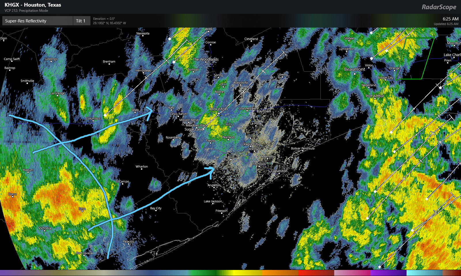
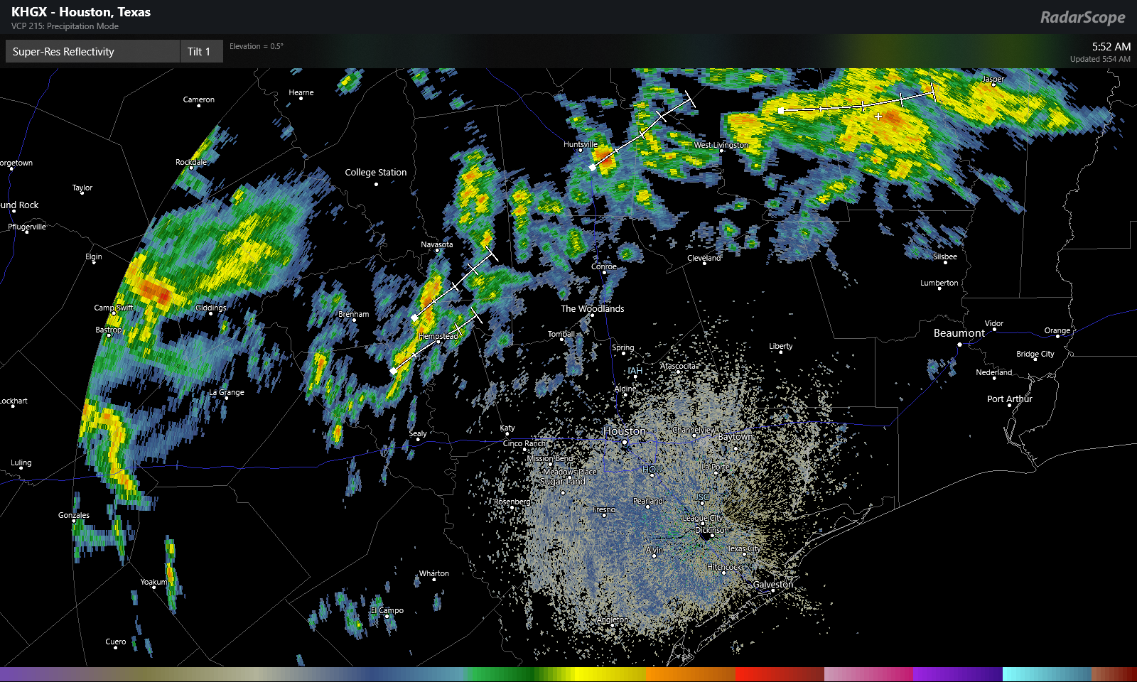
Radar as of 6:20 this morning shows sporadic showers across the region, with heavier rain marching east into Louisiana. We have one additional batch of heavy rain that stretches from near Victoria southwest to Beeville down in South Texas.
Radar as of 6:25 AM showed one final batch of moderate to heavy rain poised to move into the southeastern half of the Houston area this morning. (Radarscope)
This batch of showers will push through the southeast half of the Houston area over the next 2-3 hours. Once that clears, steady rain should end. I can’t rule out lingering light rain or drizzle the rest of today. But the risk for moderate to heavy rain ends with this last batch pushing through.
Travel
As of 6:45 this morning, there were just shy of 20 high water locations on area roadways indicated by Houston TranStar
Houston TranStar maps showed about 20 high water locations, dispersed throughout the area, as indicated by little water droplets on the map here. (Houston TranStar)
The high water locations are pretty evenly dispersed across the region. If you’re out and about early this morning, just keep that in mind and drive carefully. Never go around barricades.
Flooding
Overnight, we saw Keegans Bayou, Halls Bayou, Greens Bayou, Armand Bayou, Little Cypress Creek, and South Mayde Creek come out of their banks. As of 6 AM, several were still out of banks or at bankfull and slowly receding. Cypress Creek, Spring Creek, and Cedar Bayou are all rising but expected to stay within their banks.
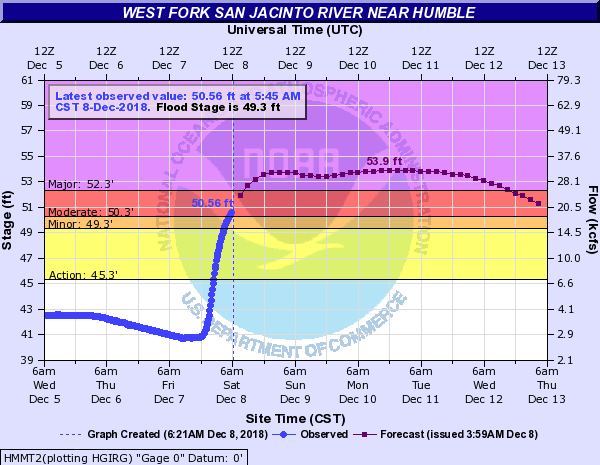
The exception to this will be the West Fork of the San Jacinto River.
The West Fork of the San Jacinto River at Humble is heading into major flood stage and will stay there for a few days. (National Weather Service)
Because of heavy upstream rains and heavy rains in the area, all that runoff is filtering into the San Jacinto River, and it is expected to crest sometime by Monday or Tuesday in major flood stage at Humble. With the forecast of a 53.9 foot crest, major lowland flooding is expected with several subdivisions impacted. You can see the expected impacts at each level on the NWS website for this particular gage. For reference, this particular location crested just shy of 51.7 feet back in March. So this will be a bit higher.
Rain Totals
Houston officially had 4.31″ of rain on Friday, making December 7, 2018 the 5th wettest December day on record in the city, going back to the late 1800s. It was also our wettest single day since August of 2017, which we all know was during Hurricane Harvey.
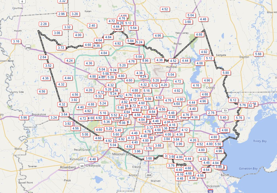
Per the Harris County Flood Control website, most of the Houston area received essentially what was forecast. Most places saw 3-5″ of rain, with a few spots seeing more.
Total rainfall seemed to average around 4-5″ in most of Harris County, with a few spots seeing near or over 6″, and a few others seeing 3-4″ or less. (Harris County Flood Control)
With rain totals like this, it’s never how much falls, it’s how much of it falls quickly that really matters and is always the challenge for us in forecasting. Hopefully we made that clear in the runup to this storm. Fortunately, we’ve now got a few days to dry out, with our next rain chance not in the forecast until at least Wednesday night or Thursday.
Good morning. Let’s get right into the forecast here, as a significant winter rainstorm begins to bear down on Southeast Texas.
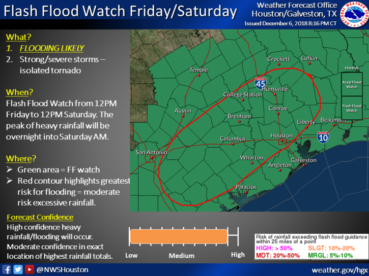
First off, Flash Flood Watches will go into effect for the entire region today and tonight.
The National Weather Service will hoist a Flash Flood Watch across the entire region at Noon today. (NWS Houston)
This means conditions will be favorable for flash flooding, street flooding, and some substantial rises in area creeks, rivers, and bayous. If you’ll be out and about tonight, you will want to have a way to receive updated weather information. Space City Weather will be updated through the night as well, but make sure you have a couple sources of the latest information and a way to see radar.
Also, something that’s occasionally underappreciated: If possible, please make sure your neighborhood storm drains are free of leaves and debris. We are “past peak” fall foliage in Houston now, and many leaves have found their way to storm drains and gutters.
Clearing these areas allows water to drain more effectively and will often mitigate some street flooding issues.
This morning
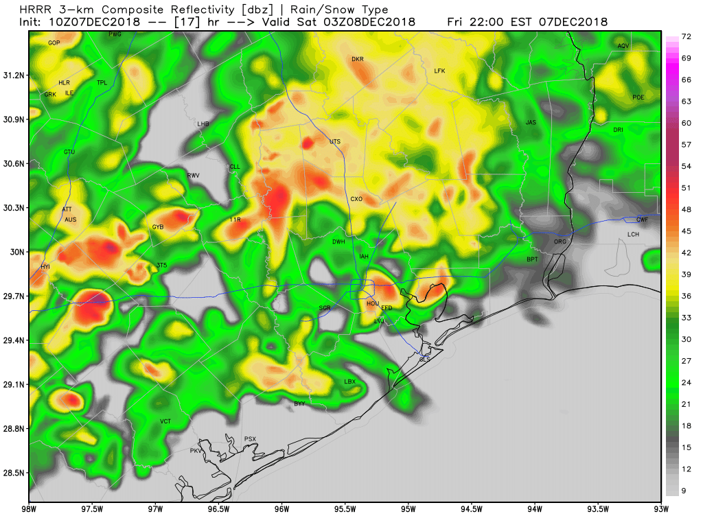
Radar this morning is quiet in Houston, but scattered showers have developed northwest of the city.
Radar as of just before 6 AM Friday shows some isolated to scattered storms and showers northwest of the Houston Metro. This will gradually slump south and east this morning. (RadarScope)
Expect scattered showers and the possibility of some thunder to continue through the morning hours north and west of Houston. This area should advance closer to Houston as well, bringing some rain chance to the city by late morning.
This afternoon
Expect showers and thunderstorms to become more numerous and widespread as we go through the afternoon, especially along and northwest of US-59. We will want to watch this to see if rain can advance farther southeast than expected, as this could push the steadier rains more into the central part of the Houston metro, rather than it being skewed northwest. Regardless, I don’t anticipate that we’re going to see a lot of flooding issues around the region through afternoon. That risk ramps up tonight (read more below).
But still, I would expect that we could see on the order of a half inch to two inches of rain on average during the daytime today from the city of Houston to the north and west, with lesser amounts south and east. However, we will need to watch southern and eastern areas later this afternoon for some isolated potentially strong to severe storms.
This evening
Steady rain could taper to scattered showers in spots, but in general, expect occasional showers, downpours, and thunderstorms through midnight, with the greatest concentration from the city of Houston to the northwest.
The HRRR model radar forecast for 9 PM tonight shows scattered to numerous downpours and thunderstorms across the area, especially along and north/west of US-59. Use caution if out and about tonight. (Weather Bell)
The image above is a forecast radar for 9 PM this evening. You get a sense of the patchy nature of things. Not everyone will be in downpours constantly, but some areas will get hit more often than others. If you get into a lull in the rain, just be advised that the event isn’t over and heavier rain will be incoming overnight from the west.
Overnight
This will be the main event. A strong, slow moving line of thunderstorms will plow across the entire region around or after midnight. This band of storms will be capable of producing 1-3″ of additional rain, or more, in short order as it moves west to east across the area. After today’s rains, grounds will be saturated, and runoff will be quicker than usual. This will be the band of rain most capable of producing widespread street flooding and leading to rises on bayous in the area. The areas most vulnerable to flooding will be those that see the most rain during the day today and in the early evening. Our assumption is that we’ll see this occur along and northwest of US-59. But we will obviously know more this afternoon as this event begins to setup.
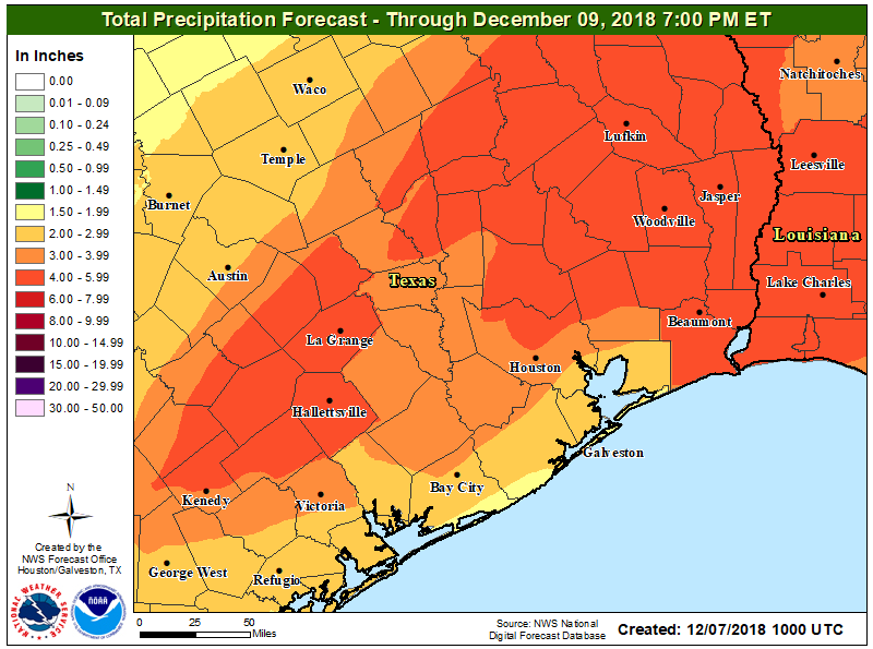
Rain totals of 2-5″ on average are expected across the region between today and tonight. There is a chance areas southeast of Houston will see less rain, and a chance that a few places from Houston north and west could see as much as 5-10″ of rainfall. (NWS Houston)
Once all is said and done, we expect two to five inches of rainfall across the area, with a few locations perhaps seeing as much as five to ten inches of rain. That will not be the case in most of the area, but there will be dollops of some of those bigger ticket totals in parts of the region. As noted, where those occur will determine who exactly is at highest risk of flooding. Obviously, use extreme caution if you’ll be travelling tonight and never drive through flooded roadways, especially at night, when it’s extremely difficult to judge how deep that water is that’s covering the road. Eric will have an update on how things are progressing later today.