Today, we’ll walk you through the forecast once more. Toward the end, I have tried to ask and answer the most common questions folks would have about the upcoming rain event this weekend. I think you’ll find most of your answers there.
Today through Friday
No changes to the forecast the next few days. Expect more partly to mostly sunny conditions. High temperatures will peak in the low- to mid-90s. Yes, a few showers or a thunderstorm will be possible on each day, but consider yourself lucky if you receive one. Most of us should remain dry.
Saturday
One of the changes today is that Saturday now looks like our transition day instead of Friday. Precipitable water values, which measure the availability of moisture in the atmosphere, go from about 1.5 inches on Friday to 1.9 inches on Saturday. What does this mean in layman’s terms? It means rain chances should go up a notch. As of right now, Saturday’s rain and storm coverage shouldn’t be terribly significant, but it will be more than we’ve seen lately. Locally heavy downpours could occur Saturday as well. With more clouds and rain, temperatures will ease back a bit, and we may not even hit 90 degrees for a change on Saturday.
Pretty status quo weather the next few days. Expect partly to, at times, mostly sunny skies, with highs in the low- to mid-90s. Rain chances will tick up each day just a little bit. Expect maybe just one or two showers today, then perhaps three or four showers tomorrow. You get the idea. Thursday will be the best rain chances of the next three days, but even that should only result in isolated to scattered thunderstorms in the afternoon as it stands right now.
Friday
Friday appears to be our transition day from the pattern we’ve had most of summer so far to the higher moisture and rain chance pattern, influenced heavily by what happens in the Gulf. Expect highs in the upper 80s to around 90 degrees with a smattering of afternoon thunderstorms in spots, though still very hit or miss.
Back to back mid-90s this weekend, though many of us saw showers on Saturday at least. This pattern will continue much of this week before we watch the tropics later in the week from the Gulf. Let’s dive in.
Today through Wednesday
I don’t see a ton of day to day differences between today, tomorrow, and Wednesday for most of the Houston region. Models are mostly not excited about rain chances, but I do think with daily sea breezes kicking up off the Gulf, we should see at least a smattering of a few showers in parts of the area each of the upcoming days. We’ll characterize it as: Most of the time & area will be dry, but if you’re lucky, you may see some showers once or twice through Wednesday.
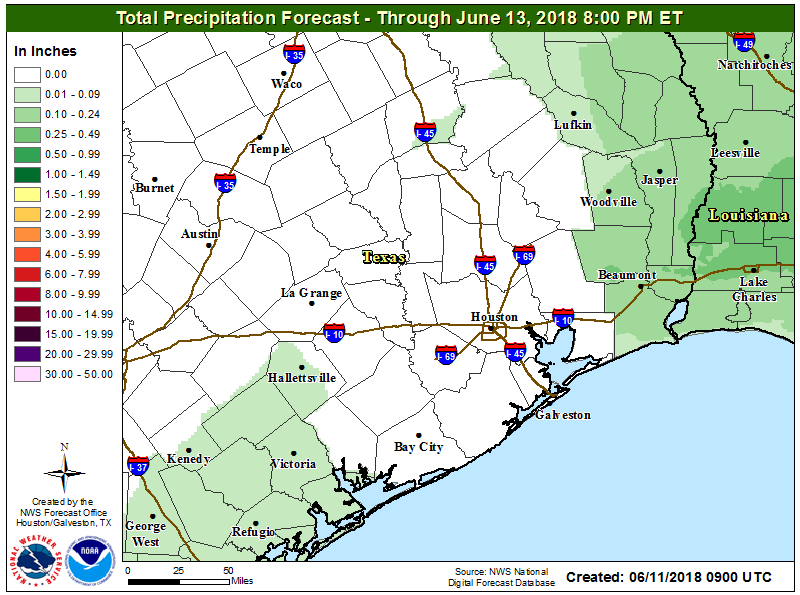
The NWS Houston rainfall forecast through Wednesday evening is mostly blank. While some of us will see a shower or two, most of us will remain dry. (NWS)
We have a fair bit of cloud cover around this morning, so we’ll call it partly sunny today and a mix of sun and clouds tomorrow and Wednesday. Temperatures will be pretty steady. Expect average high temperatures in the mid-90s (93-96 on average) with low temperatures in the mid to upper 70s. Basically, what’s normal for mid- to late-July.
Thursday & Friday
The forecast beginning Thursday gets a little muddier because of the possible tropical wave in the Gulf (which I discuss in more detail below). But, in general, expect an uptick in atmospheric moisture Thursday afternoon, with a slightly better chance of showers. That continues into Friday. Again, this is nothing too well organized, but rather scattered showers or a chance of storms each afternoon, perhaps at a greater coverage than Monday through Wednesday. Temperatures may back down a couple degrees here with higher rain chances, so we’ll call it low-90s.
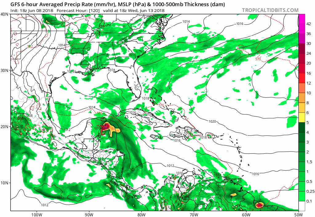
Matt here with a special Friday evening update for you, Houston. Yes, the late afternoon run of the GFS operational model showed a significant tropical system crashing into the Texas coast. Some of us in meteorology refer to this as the “happy hour” run of the GFS. I’m going to walk through a pretty basic forecasting approach to whether or not I would put much (any?) stock into the GFS operational model.
The model run
If you’re curious, here it is:
Today’s 18z “happy hour” GFS operational model spins a hurricane into Texas next weekend. No, we aren’t buying into it. (Tropical Tidbits)
No, you should not worry about it.
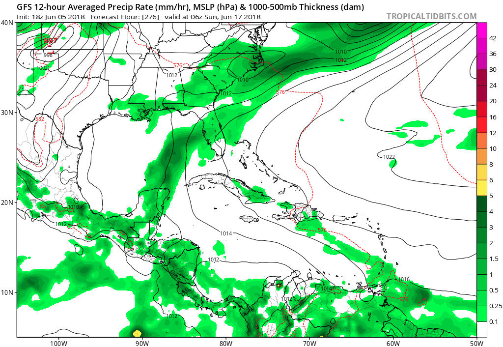
The trends
Why am I saying that? If you look at the last 10 runs of the forecast from this very same model valid for next Saturday night, today’s is the first to show a storm in Texas.
Of the last 10 GFS operational runs, only the latest one wants to bring a hurricane into Texas. (Tropical Tidbits)
Sure, the last couple runs have trended closer to Texas, but this model is volatile. It’s going to bounce around a lot. I’ve been watching this model for 15 years now. This isn’t an abnormal thing it does.
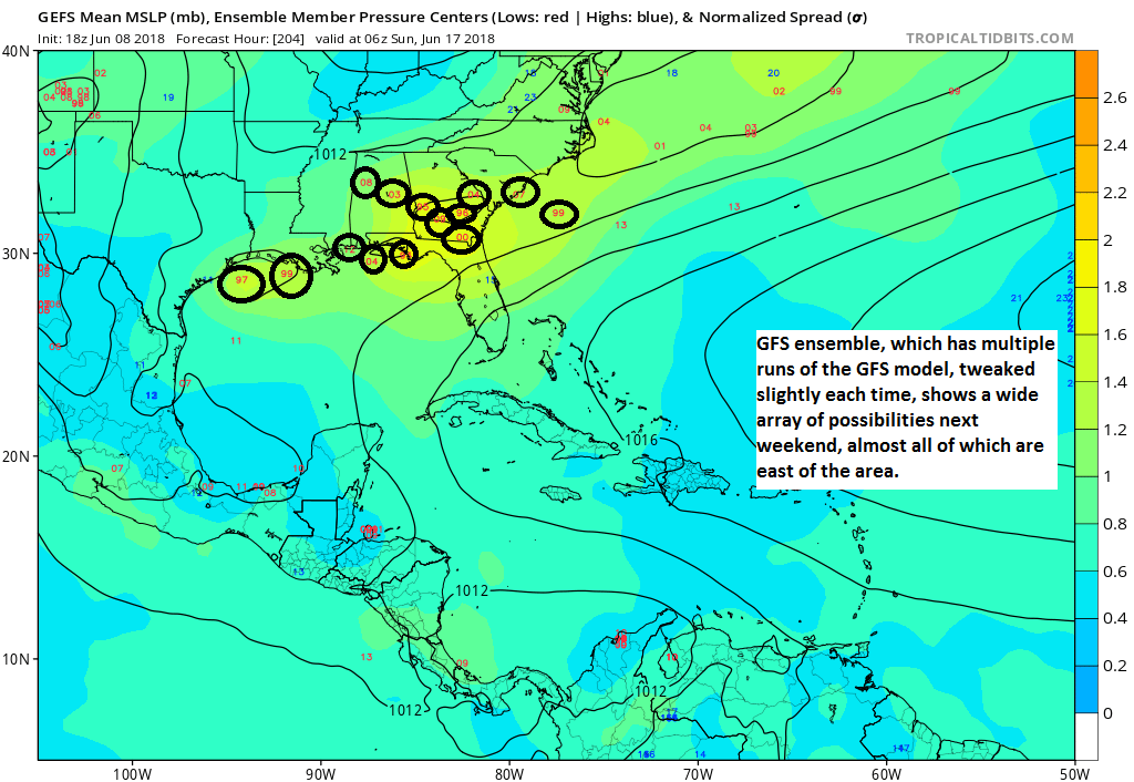
The ensemble
On top of all this, let’s look at what the GFS Ensemble shows for this same exact timeframe. The ensemble is still basically the GFS model, but it’s run multiple times with some tweaks to the model each time. The intent is to offer you more of a “spread” of possibilities in the forecast. Good forecasters use ensemble based forecasting techniques to help them craft forecasts. I’m focusing on one particular variable here: What each ensemble member shows for sea level pressure centers. Each circle I’ve added to this map is where an ensemble member places the center of something (tropical storm, hurricane, plain old tropical disturbance) next Saturday night.
The ensemble “spread” next weekend is still fairly large, most are much weaker than the operational, and the skew is to our east. (Tropical Tidbits)
So even the GFS model’s ensemble is saying that the operational model is probably a.) much too strong and b.) too far to the west.
Sidebar, the maps above are from Tropical Tidbits, which is a great site I use. If you’re into veering into the weather weeds, it’s worth perusing. By the way, the owner of that site is a hurricane researcher at Florida State University. He had this to say about that GFS model run:
While an upper trough may generate a surface trough near Central America next week, the Day 6-7 GFS in the Gulf of Mexico is not worth paying attention to, unless more reliable guidance moves that direction over the next few days.
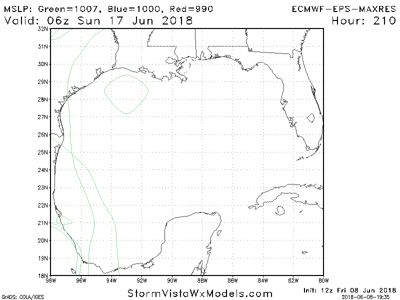
Everyone loves the Euro, so I’ll just tell you, it doesn’t show this solution. What about the European ensemble. That ensemble contains 51 different members. All of one of them, shown below via another good weather model site, StormVista, has a closed off low pressure under 1007 mb (weak) next Saturday night.
The Euro ensemble is decidedly less aggressive with tropical development next week and weekend. (Storm Vista Weather Models)
There are other models we can look at, but truthfully, none is really reliable enough at this point to utilize with any confidence.
So what should I expect, then?
Here’s what we *do* know.
Based on forecaster experience, the GFS tends to grossly overdo tropical development, while the European model tends to underdo it. So I think the Euro probably isn’t giving enough credit to potential tropical development in the Gulf late next week, but the GFS is probably way too enthusiastic about it.
Weather modeling indicates that rain chances should increase a little bit later next week as a tropical wave finds itself in the Gulf. Weather modeling indicates two real possibilities at this point. One is a disorganized, weak system heading toward the Florida Panhandle again. The other is just an increased slew of moisture heading toward deep south Texas (Corpus Christi and the Rio Grande). This could be what’s needed to kick start rain chances a bit more in Texas. With that said however, I am a little concerned it may get directed just a little too far south to really offer the Houston area much relief.
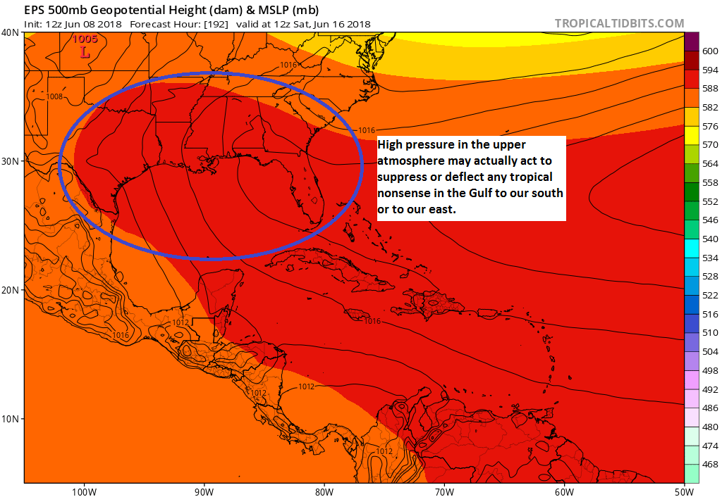
So, my thoughts have not changed at all today, truthfully. Why? I’ve been watching this pattern all week. At my day job, I’ve actually been discussing this setup since last week with my summer intern. If you look about 20,000 feet up in the atmosphere, you see high pressure extending across the Gulf into Texas next weekend.
As of right now, I think the upper level pattern over the northwest Gulf favors any tropical nonsense staying to our south and east, should it develop. (Tropical Tidbits)
My current thinking is that if this holds up, strengthens further, or a portion of it closes off over Texas and Louisiana, that would likely suppress any developing tropical system near the Yucatan to our south toward the Rio Grande or allow it to move north-northeast within a weakness in the ridge toward Florida. Should this high pressure weaken overall, yes, then maybe we might have to watch the Gulf a little closer. Or it could just be a stream of tropical moisture that finds its way up here and allows us to have daily afternoon showers and storms at a greater frequency next weekend.
I’m not just saying this to dampen hype. I truly believe this meteorologically: I don’t believe that whatever does develop in the Gulf will be anywhere near the scare-icane shown on today’s happy hour GFS model. But as always, we will continue monitoring.