Periods of heavy rain and thunder could lead to street flooding Sunday across the Houston area

Good morning. We just wanted to offer a Sunday post for a couple reasons. First, obviously, after this week’s storms, we know a lot of people are going to be sensitive to the mention (or sound) of thunderstorms. Secondly, we have more confidence in today’s forecast.

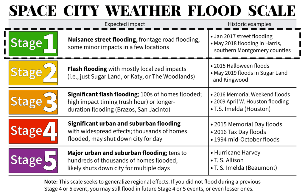
What’s changed since Friday? Honestly, not a whole lot. We’re getting areas of heavy rain, as expected. But I think both confidence and intensity of heavy rain has increased enough for us to place the area under a Stage 1 flood alert on our flood scale.
We have already seen parts of western Harris County, which were hardest hit this past week in terms of rain see over 2 inches of rainfall. The Weather Prediction Center has kept much of the area under a slight risk (level 2/4) of excessive rainfall for today.
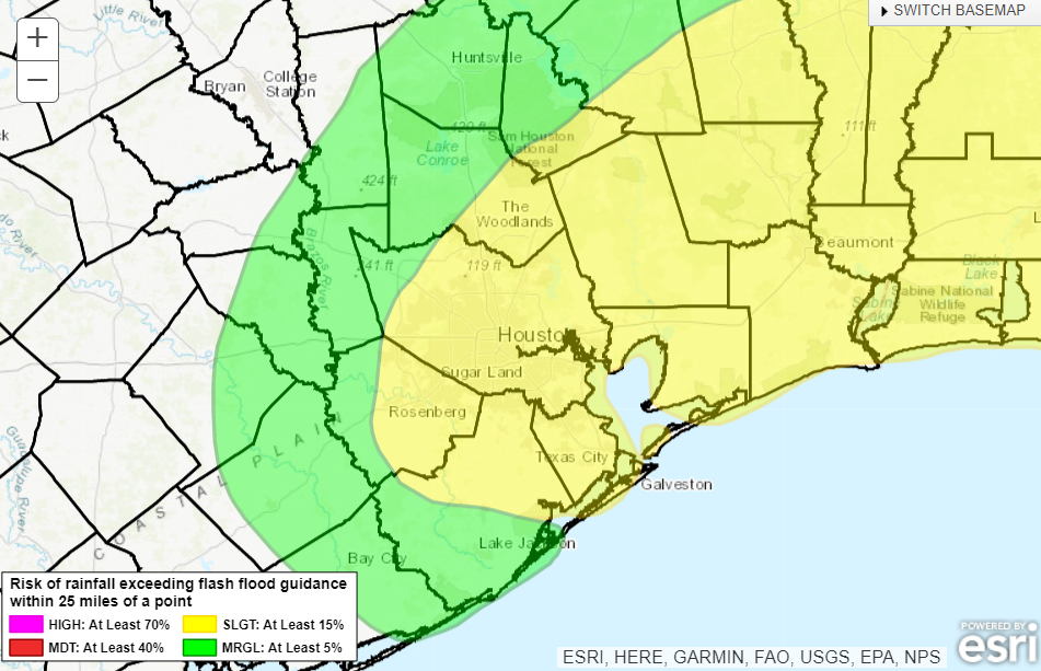
Most of the area is under a “slight risk” of excessive rainfall today. (NOAA)

Basically, given Tuesday’s rain, the fact that today’s rain is performing or overperforming to this point, and the shorter-range model guidance for the rest of today, we felt it necessitated an upgrade in messaging. So, please watch for areas of street flooding, especially across western Harris, northern Harris, southern Montgomery, Liberty, and Chambers Counties today, east to Beaumont.
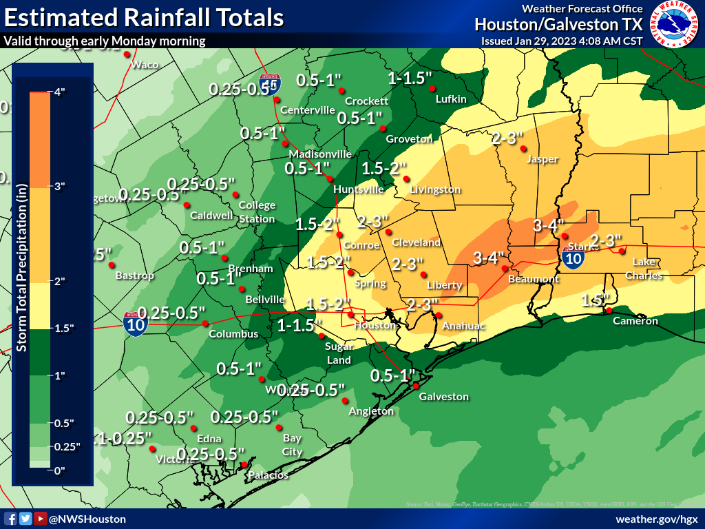
Expected rainfall today from the NWS. Some areas have already seen close to these amounts, so this is why we emphasize that these maps should be taken as an “average” forecast. Rain totals could reach 3 to 5 inches under the most persistent heavy rain bands today.

Radar as of 8:35 shows numerous areas of heavier rainfall, especially near Liberty and Cleveland, as well as across northern and western Harris, Montgomery, and Wharton Counties.
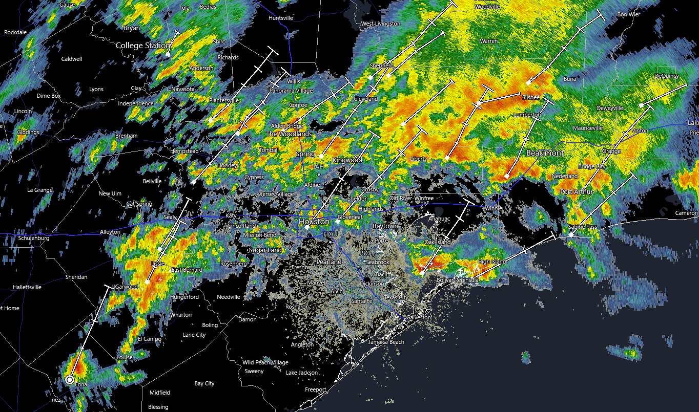
Radar as of 8:35 shows widespread areas of heavy rainfall. Street flooding remains the biggest concern today. (RadarScope)

With a front essentially crawling across the area today, repetitive rounds of storms are likely, and that’s why we have the flooding risk. Rain tapers to isolated showers this evening.

Severe weather

We want to be clear about today’s forecast. Two things can be true simultaneously: 1.) Some of the storms later this morning or this afternoon could be strong to severe. 2.) This setup looks absolutely nothing like the one that caused Tuesday’s severe weather and tornado outbreak.
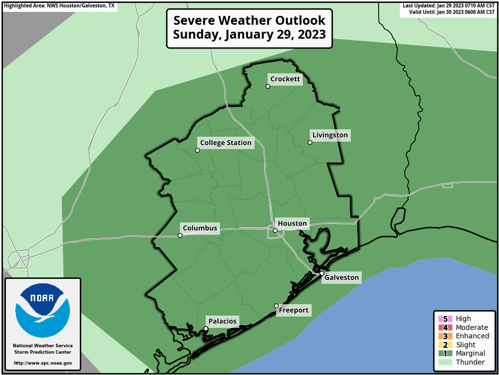
The entire region is outlooked in a marginal (level 1/5) risk for severe weather today. Very isolated strong to severe storms are possible, but this setup is nothing at all like Tuesday’s was. (NOAA)

This looks to be more of a classic Houston severe weather setup, with the risk for isolated cells producing gusty winds, hail, or yes, even a brief spinup. The odds of this are modestly higher east of Houston into Louisiana. I wouldn’t dwell on this too much about this today, but I also did not experience a tornado on Tuesday, so I get it. It’s a good idea to just monitor the weather through the afternoon to be safe.

Monday & Tuesday

Additional showers are possible on both Monday and Tuesday this week, but at this time, we do not expect heavy rainfall. That chance may increase later in the week, however.

The front is going to essentially stall out over the area. What that does is create challenges for temperature forecasting. I would anticipate Monday being a cool day right now with temperatures generally in the 50s. All bets are off on Tuesday and beyond. Ensemble guidance projects high temperatures on Tuesday could be as low as 50 degrees or as warm as 75 degrees. Basically, the exact location of the front will determine how warm or cool we get in the days ahead. Have your wardrobe planned for multiple seasons this week. Eric will detail this more on Monday. We will update (if needed) again later today.


A gray Saturday and a soggy Sunday morning for Houston

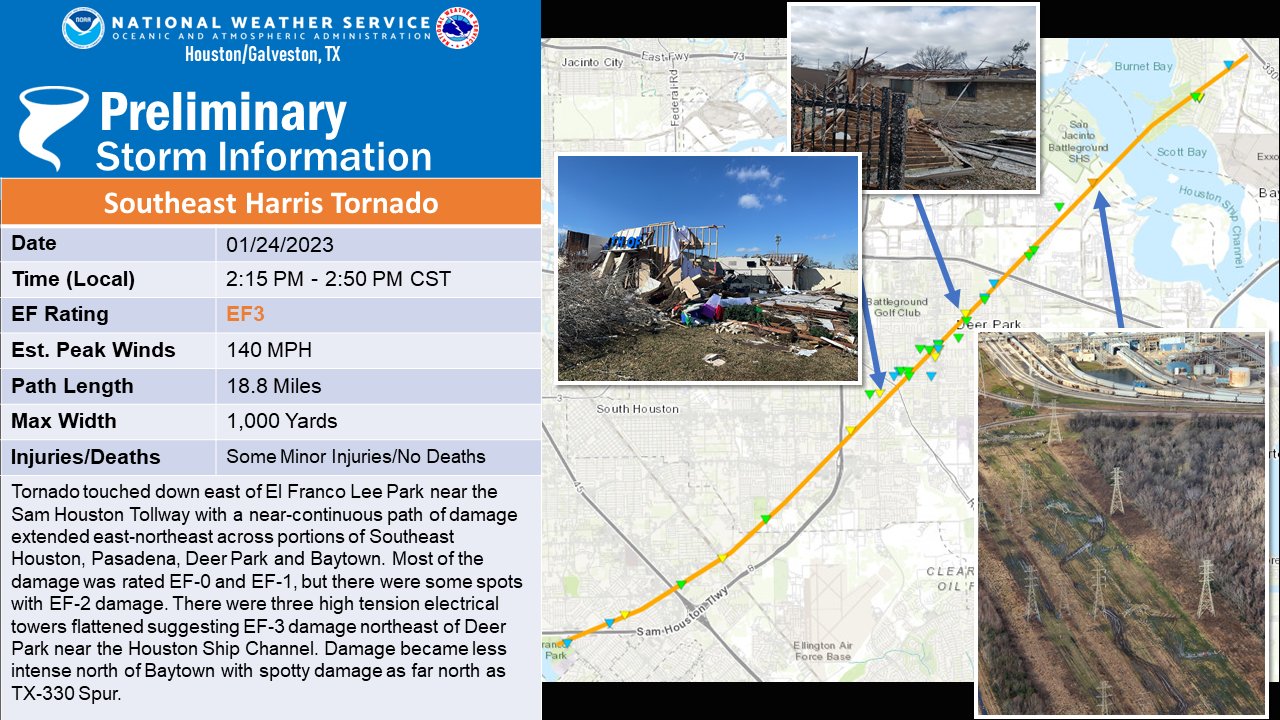
Before we get into the forecast today, we just want to go over some of the news from the National Weather Service office in League City from the last couple days. First off, the tornado that ravaged parts of Pasadena, South Houston, Deer Park, and Baytown was classified as an EF-3.

The tornado in southeast Harris County on Tuesday was rated an EF-3, based on damage to high voltage power towers that had been flattened, a common indicator of a tornado of that intensity. (NWS Houston)

It was the first EF-3 tornado in Harris County since 2002 (La Porte).

Two additional tornadoes have also been confirmed in the Houston area. Both were rated EF-0. One traveled about 14.5 miles from Needville through Thompsons in Fort Bend County. The other occurred in Pearland, preceding the South Houston tornado and was on the ground for a bit over 2 miles.

In Liberty County, an EF-2 tornado has been confirmed, but details are not expected on that until a little later today.

The last couple days have been mercifully placid, and we look to get one more of those before some more rain.

Today

Friday should be a mostly fine day, with intervals of sun and clouds and temperatures popping up to near 60 degrees.

Tomorrow

Clouds will really increase and thicken up tonight into Saturday. By late tonight and early Saturday morning, a few showers should begin to break out, along with periods of drizzle or light rain. We don’t currently expect Saturday to be a washout, but you’ll probably see a few raindrops in much of the area. The clouds and showers will compete with warm air flowing in from the Gulf of Mexico, so after a mild morning in the mid or upper-50s, we will likely warm to near 70 degrees. You will also notice the wind picking up some on Saturday afternoon, with gusts to perhaps 25 mph or so.

Sunday

The next in a series of systems will impact us late Saturday evening and Sunday. Look for rain to break out as a coastal low develops. This system will lack much of what Tuesday’s had for significant severe weather. We do not expect serious severe weather, but a few stronger thunderstorms are possible. That said, we have plentiful moisture available Sunday, and we will be looking for the potential of locally heavy downpours, especially in the morning. This would be most likely south of I-10.

The southeast half of the Houston area has been placed in a slight (level 2/4) risk for excessive rainfall on Sunday, meaning localized downpours could lead to some street flooding. (Pivotal Weather)

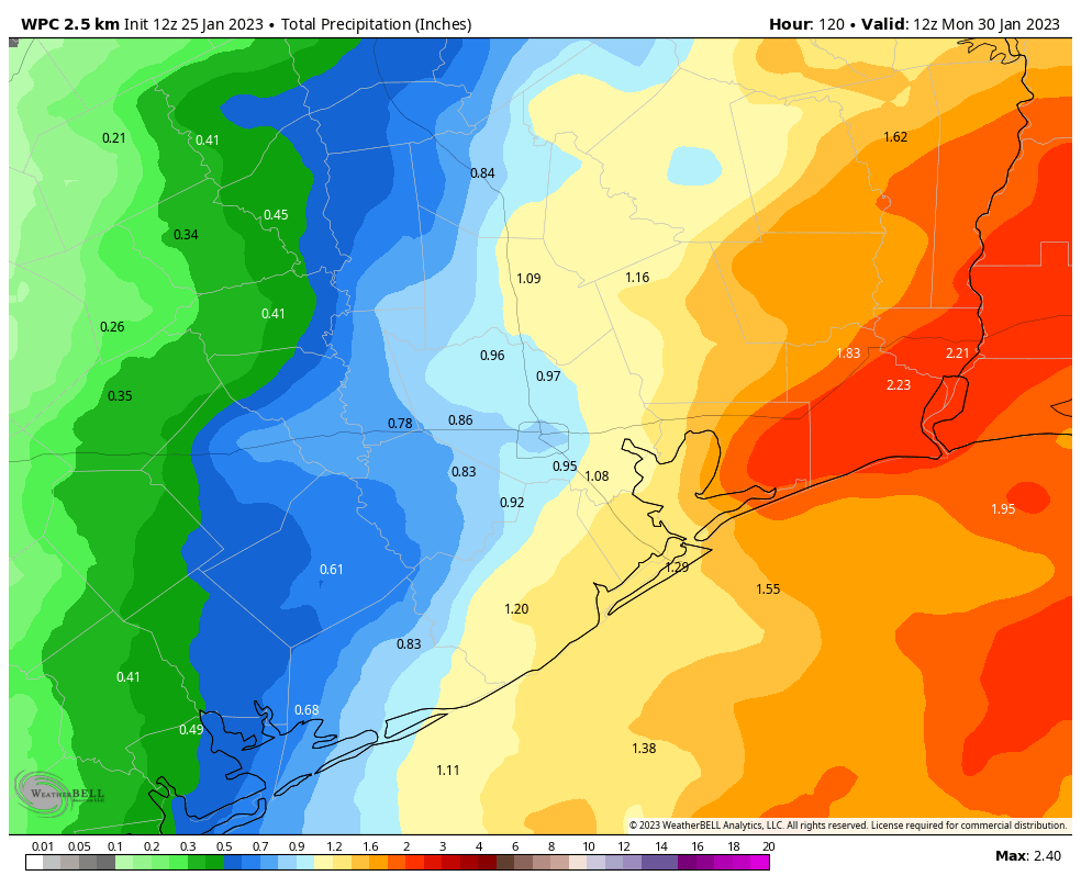
Right now, the Weather Prediction Center has the region in a slight (level 2/4) risk of excessive rainfall. We don’t expect rain quite of the intensity we saw on Tuesday, but given the wet ground, we could see some areas of ponding or street flooding emerge Sunday morning under the heaviest rain. In addition, water levels on creeks are still high in parts of the area, especially north and west of Houston, so any heavy rainfall will likely exacerbate that a bit. Expect an inch or two on average southeast of Houston, with lesser amounts as you go north and west of the city.

Conditions should gradually improve later Sunday afternoon and evening. We will top off in the 70s.

Early next week

Early next week looks dominated by this front that gets hung up over our area on Sunday. That will likely be in place through Wednesday. The problem from a forecaster’s perspective is that it’s going to wobble around. That means that there’s probably going to be a pretty annoying gradient of temperatures over the region next week, with readings ranging from the 50s to the 70s depending on the exact position of the front. In addition, rainfall will be possible through the entire period, although it looks mostly minor in nature until later Wednesday or Thursday. We should have a little more clarity on the exact daily details Sunday or Monday.

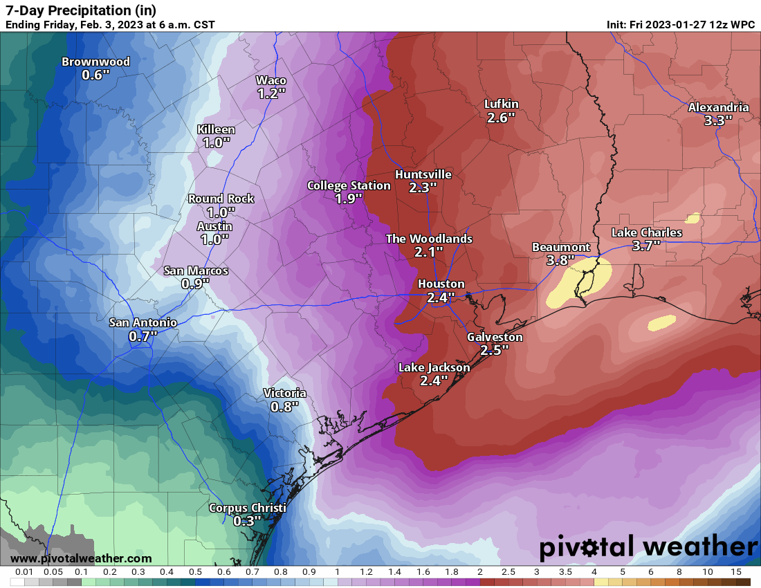
Total rainfall through next Friday morning should be 1 to 4 inches across most of the region. Higher amounts are possible in spots, especially south and east of Houston. Some lower amounts may occur north and west. (Pivotal Weather)

Next front

Our next real front of significance after Sunday will come on Thursday it appears. Expect a period of showers and storms, along with some locally heavy rain. This should usher in a slightly less active pattern and a chilly air mass in time for next weekend. We do not expect a significant freeze at this point, however. We’ll update you on that Monday (or Sunday!) as well.

A couple of sunny days before our pattern turns more gray for awhile

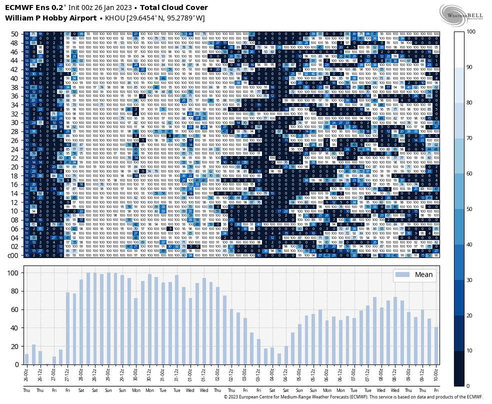
Houston will enjoy another day or two of sunny weather before cloudier and rainier conditions return to the metro area for awhile. The rain chances will peak this weekend, but gray skies will probably remain until next Wednesday or Thursday. So soak up some rays today, if you can.

Thursday

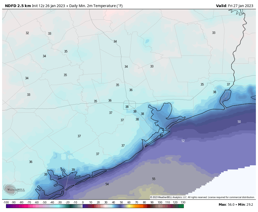
Temperatures have generally fallen into the upper 30s this morning, with light northerly winds. We will see plenty of sunshine today, and this will allow highs to climb into the upper 50s. Low temperatures tonight may be a degree or two colder than Wednesday night, as winds become calm and there is little mixing.

Low temperatures on Thursday night will be cold in Houston and surrounding areas. (Weather Bell)

Friday

Skies will be partly to mostly sunny, but as high pressure slides east we will start to see a southeasterly breeze. This will introduce a few clouds, and moderate temperatures. Lows will only fall into the low 50s on Friday night.

Saturday

Our pattern turns more complex by the weekend, with a southerly flow and more disturbed atmosphere. Skies will be cloudy on Saturday, and some light, fast moving showers will be possible. With the southerly flow the air will turn a bit more muggy, and highs will climb into the low 70s. Rain chances start to perk up during the evening hours, and I expect fairly widespread showers after midnight, into Sunday morning. If you have late night plans, prepare to dodge showers.

Sunday

Rain chances will probably start to diminish by Sunday morning, but the potential for showers will remain through much of the day on Sunday. Overall, I expect on the order of 0.5 to 1.5 inch of rain this weekend. That’s not a huge concern, flood-wise, but it will be a nuisance. Highs on Sunday should reach the low- to mid-70s, with continued cloudy skies, before a weak front drops most of the area into the 50s on Sunday night.

Cloudy skies, indicated by white in the ensemble forecast above, will be prevalent from late Friday through next Wednesday. (Weather Bell)

Next week

Sunday’s front will be short lived. Accordingly, we’ll see chances for (mostly) light rain through the first three days of next week, along with gray skies and warm temperatures in the 70s. The pattern finally starts to change some time on Wednesday, when the next front arrives and may act to clear out our skies. I think we’re probably looking at a few days with highs in the 50s and lows in the 40s, but this far out the details are fairly blurry. We should start to see at least some sunshine again by next Thursday or so.

Calm, cold conditions as Houston cleans up from Tuesday’s storms

Good morning. Matt has posted an excellent recap of Tuesday’s wild weather, which included what we believe to be the Houston area’s most destructive tornado since November 1992. Our thoughts are with those who suffered damage from this catastrophic event. Fortunately, calmer weather lies ahead. The story over the next two or three days will be the cold, with lows dropping into the 30s. After that we’ll return to a wetter and warmer pattern this weekend.

Wednesday

High pressure has settled over the area, and that means we will see clearing skies after a mostly cloudy start. Winds will be gusty, out of the north at 10 mph, with gusts up to 20 mph. Temperatures are starting out in the low 40s this morning, and we’re not going to get much above the mid-50s. These readings, combined with the winds, necessitate a sweater or a jacket today. Lows tonight will drop into the upper 30s in Houston, with cooler conditions inland. Winds will slacken some.

Thursday

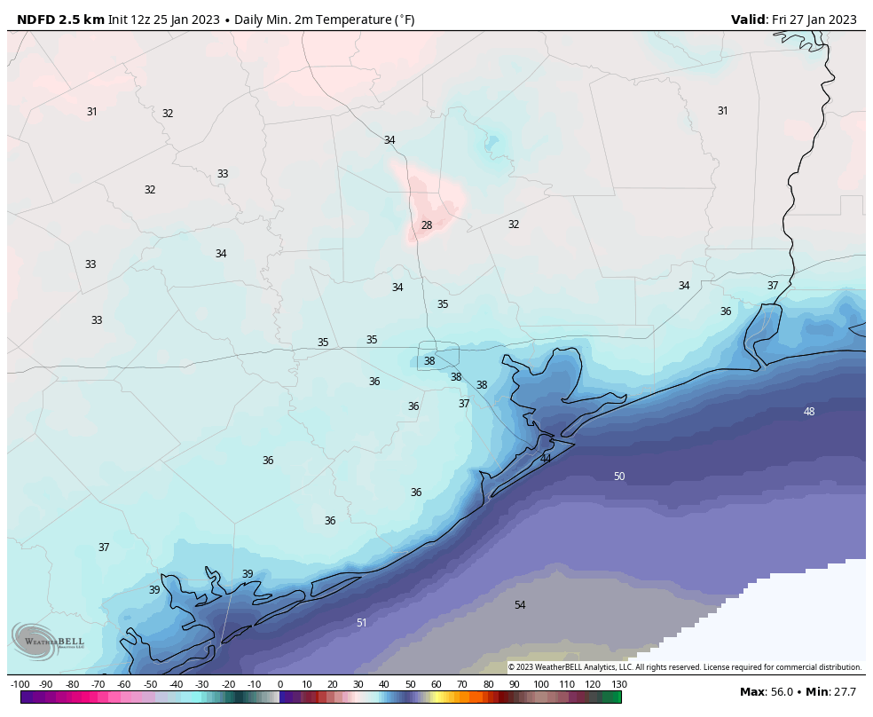
Expect a sunny, chilly day with highs in the mid- to upper-50s. Winds will be light, at 5 to 10 mph. This will lead to ideal cooling conditions for Thursday night, with lows dropping into the upper 30s in Houston, and colder further inland. Some areas in places like Montgomery County could possibly see a light freeze.

Forecast low temperatures for Thursday night and Friday morning. (Weather Bell)

Friday

Another mostly sunny day, with highs around 60 degrees. However, as winds shift to come from the southeast, our dry and cold air mass will start to modify. Lows on Friday night will probably only drop into the low 50s.

Saturday

So long, sunshine. After the departure of high pressure and resumption of the onshore flow, we’ll see a cloudy day. Some light, scattered showers will be possible during the daytime, becoming more numerous during the evening and overnight hours as a disturbance moves overhead. With this southerly flow, temperatures will reach about 70 degrees during the daytime, with lows only dropping slightly, into the low 60s on Saturday night.

Sunday

Alas, rain chances will remain elevated at least for Sunday morning before the atmospheric disturbance finally departs to the east. Highs will likely reach the low 70s. In terms of accumulation, I expect most of the area to see roughly 1 inch of rain, give or take, during the weekend. Areas to the east, including Beaumont, could see 2 or more inches. A weak front arrives on Sunday to push overnight lows into the 50s, probably.

NOAA rain accumulation forecast for Saturday and Sunday. (Weather Bell)

Next week

Monday may only see highs in the 60s, but Tuesday and Wednesday will probably be in the 70s, with muggy and warmer conditions. After that there is general agreement in the forecast models on a stronger cold front pushing into Houston. As this is at least a week out, the details are understandably lacking. I think lows in the 30s are probably likely, and I would not rule out a freeze. If you’re thinking about planting your garden I would hold off a little bit longer, just in case.