Sunny, cool, and dry weather to continue for awhile

Houston will continue to see splendid winter weather for awhile, with no major temperature or precipitation concerns. Instead, we’ll see a sustained stretch of sunny days, with moderate days and cool nights. Enjoy!

Tuesday

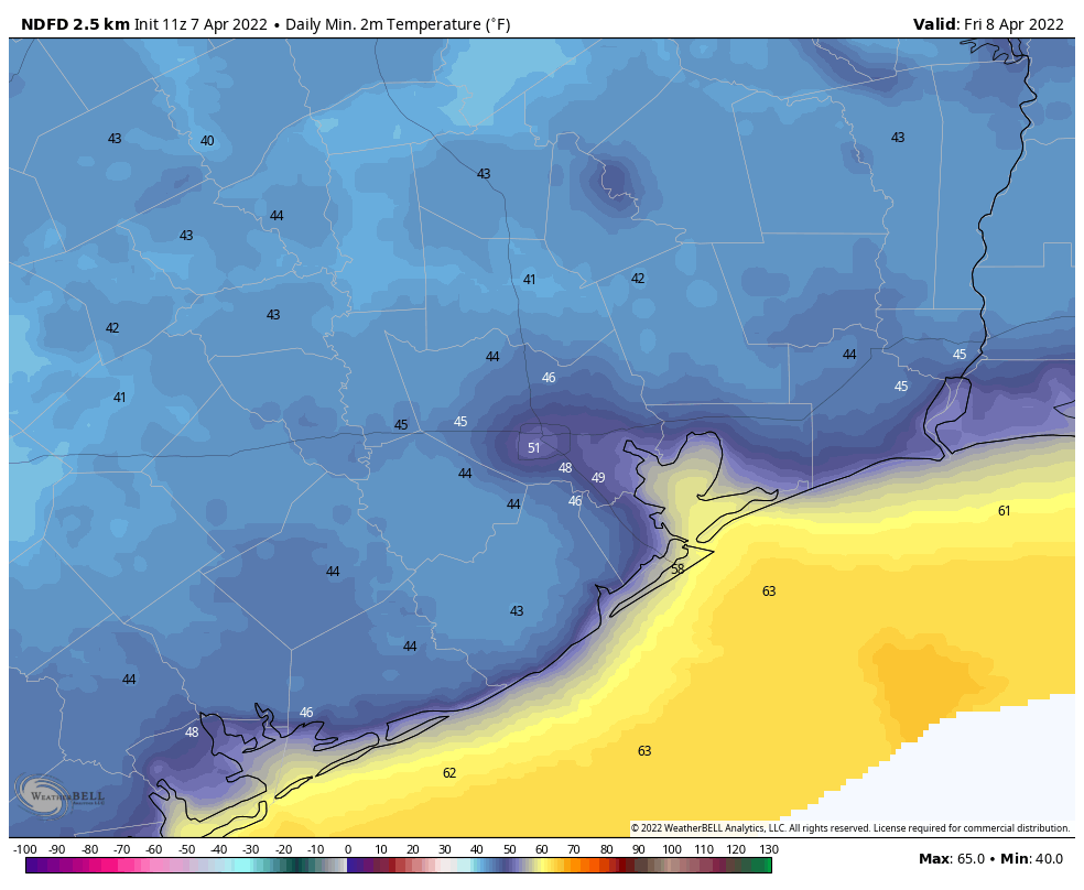
It’s cold out there this morning, but as light winds shift to come from the south later today, we’ll see high temperatures nudge up to the mid-60s beneath sunny skies. This should also help to moderate low temperatures a bit tonight, probably keeping most of the metro area at 40 degrees, or above.

Tuesday’s low temperatures, shown above just before sunrise, should be the coldest morning for the rest of this week. (Weather Bell)

Wednesday, Thursday, and Friday

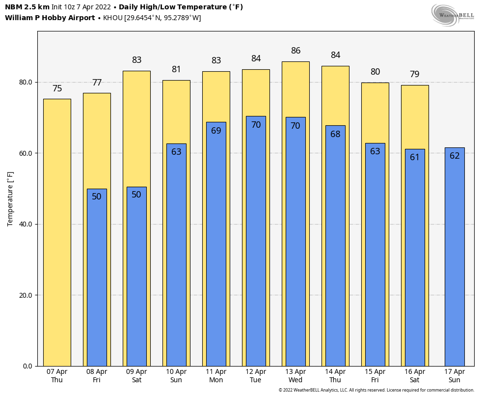
Overall, a fairly cool and dry air mass should remain in place over South Texas. Highs will generally be in the upper 60s on these days, with light southerly and southwesterly winds. Overnight lows will generally be in the 40s, although by Friday night they may only drop to around 50 degrees in Houston. Dewpoints will remain comfortably dry. Skies will be sunny, with nary a chance of rain. This is great weather for picnics, field trips, outdoor classrooms, or anything else out of doors.

Much of the area may see highs of 70 degrees by Friday. (Weather Bell)

Saturday and Sunday

The weekend forecast is coming a little bit better into focus, although there are still some questions about the details. In the big picture, a fairly strong cold front is likely to move through Houston during the daytime, perhaps after noon. So it’s likely that most parts of the region will see a moderately warm morning, and then have things cool off with the frontal passage. Some brief, light rain is possible during Saturday along with the front’s passage, but I think that’s still very much an open question. Winds will probably be breezy on Saturday night, perhaps gusting to around 20 mph, with temperatures dropping to around 40 degrees in Houston. Highs on Sunday should be in the 50s, with mostly sunny skies and a northerly breeze.

Next week

After a chilly start, I think we’ll see a more robust warm up next week with highs returning to the 70s. Widespread rain chances return to the forecast sometime after Monday as well.

Houston to see lots of sunshine and cool, dry air this week

Good morning. After a dynamic week of weather, with widespread rain showers Monday, a smidgen of freezing rain on Thursday, and then very cold weather through the weekend, conditions will moderate this week. However, it’s still going to feel winter-like out there, for Houston at least. Normal temperatures for this time of year are highs in the mid-60s, and low in the mid-40s, and that is more or less what we’re going to see.

Monday

Just as temperatures are beginning to warm, we’ll see another shot of cold air today. This will be more of a reinforcing front rather than a blustery affair, so while winds will shift to come from the north I’m not anticipating anything too gusty. High temperatures should reach about 60 degrees this afternoon, especially after clouds clear out this this morning and leave us with sunny skies. Monday night should be the coldest of the week, with lows dropping into the 30s for the metro area.

Low temperatures on Monday night across Houston. (Weather Bell)

Tuesday

A pleasant, sunny day with light winds. Highs will generally be in the low 60s. Overnight lows will be a few degrees warmer than Monday night.

Wednesday, Thursday, Friday

The upper air pattern will support continued calm weather at the surface for Houston. High temperatures on each of these days should slot somewhere in the upper 60s, with mostly sunny skies, and overnight lows ranging from the upper 30s inland, to low 40s in the city, and upper 40s along the coast. This will be a splendid stretch of winter-like weather.

Is it going to rain this week? Not likely, brother. Here’s the rain accumulation forecast. (Weather Bell)

Saturday and Sunday

The forecast for the weekend is somewhat in question due to the uncertain timing of the next cold front. The most likely scenario is that the front comes through some time between Saturday evening and Sunday morning, and for now rain chances do not look terribly high with its passage. But timing and rainfall are both subject to change. Anyway, for now, I’d anticipate partly sunny skies on Saturday with highs of around 70 degrees. Sunday could be quite a bit colder, but for now I’ll go with sunny skies and highs of around 60 degrees. A light freeze may be possible on Monday morning, but I’m not sure this front will go that cold. We’ll see!

Cold this morning but mostly quiet in the Houston area

Good morning, and it’s certainly nice to wake up to no power issues related to the grid across Texas. ERCOT’s status is normal. That being said, we do have some considerable travel issues to contend with this morning. Those should slowly improve today, and the weekend looks like a pretty nice one, if you like calm winter weather.

This morning

Current temperatures across the Houston area are in the mid to upper-20s away from the coast and generally around the low-30s at the coast.

It’s a cold morning across the area, but temperatures will slowly warm up through the day. (NOAA)

Wind chills are about 10 degrees colder than this, with mostly low to mid-teens around the region.

Precipitation ended for most folks yesterday evening, and radar is quiet this morning across the area with everything basically offshore now. But the damage is done in terms of road conditions west of Houston. Icy patches are still being reported west of Katy and in far northwest Harris County. While you should be able to maneuver for the most part around the Houston area this morning, please use extra caution on bridges and overpasses, which could still have some icy patches.

Icy patches are reported mostly west of Katy and up toward Magnolia. Traveling toward Dallas or Austin may be challenging today, however. (TxDOT)

If you are traveling away from Houston today, use extreme caution. If you can postpone travel to Austin or Dallas, it’s probably advisable, as road conditions should not improve a lot today in those areas. Travel to San Antonio is probably manageable after this morning, but again, please drive carefully. Monitor road conditions at drivetexas.org.

Rest of today

Clearing is not expecting to be total today, and the most I’d bank on right are perhaps some brightening skies this afternoon. Otherwise, a lot of clouds. That will keep temperatures from getting much above 35 degrees today. It’s just straight up cold.

Tonight

Another round of light to moderate freezing temperatures should be expected tonight.

Temperatures will dip below freezing again in most of the area tonight with mid-20s north and west of Houston. (Pivotal Weather)

Continue to keep plants and exterior pipes protected especially and make sure to check on any vulnerable friends, family, and neighbors, as this is a prolonged cold event for our area.

Weekend

The weather this weekend looks just fine. After the chilly start to Saturday, we’ll warm up well into the 40s during the afternoon with sunshine. It will be cold again Saturday night, but this time only the outlying areas will see meaningful freezing temperatures. Expect low to mid-30s in Houston and along the coast and upper-20s to 30 or so away from the city and coast.

Sunday morning’s temperatures will not be quite as cold as today or Saturday. (Pivotal Weather)

Sunday looks delightful as well. We’ll see more sunshine and highs push back above 50° Sunday afternoon!

Early next week

A weak disturbance will likely stay offshore on Monday, but I do expect us to see some clouds and at least a rain shower chance along the immediate coast. Any rain won’t amount to much there, if it happens at all. Once that system passes, it will usher in a bit of a reinforcing shot of cooler, drier weather, along with more sunshine for midweek. Look for highs in the 50s Monday and Tuesday and perhaps cracking 60 again by Wednesday. Lows will be in the upper-30s to near 40 on Monday morning, then probably back in the 30s on Tuesday and Wednesday mornings.

At this point, I’d expect generally cooler than normal weather to continue through at least Valentine’s Day. Perhaps warmer weather will be in the cards after then. We’ll see.

Treacherous travel north and west of Houston, but precipitation is winding down

First off, travel is becoming very treacherous in parts of western Harris, northern Fort Bend, Austin, and Waller Counties. According to the Drive Texas map at 8:30 PM, there are icy patches in many spots west of Houston. A 10-vehicle crash was just reported on the Westpark Tollway in Clodine.

Patchy ice is beginning to cause hazardous travel west of Houston. If travel can be postponed tonight, it’s advised. (TxDOT)

If you can avoid travel tonight, it’s best to do so, especially west of Houston. If you cannot, please use extreme caution, especially on bridges and overpasses. Based on reports to our west, once temperatures hit 29 to 30 degrees, that’s generally when ice issues seem to begin. Most of the close-in Houston area is 30 to 32 right now, but it drops to 29 and 30 north and west of there. I would expect to see some major freeway flyovers on the west side of the city close soon, if they have not already. South and east of Houston, temperatures are still 33 to 34 degrees, so icing isn’t a concern for now.

As far as the good news goes, it would appear that a lot of the precipitation is exiting the area or weakening. Radar as of 8:35 PM shows the heaviest, steadiest precipitation either along the coast or exiting to our east. This should continue to wane over the next few hours.

Radar this evening shows most precipitation beginning to wind down and exit to the east of Houston. (RadarScope)

That said, we will likely see pockets of light freezing rain or freezing drizzle continue a little longer this evening before shutting down overnight. And with temperatures not warming up until late morning or early afternoon tomorrow, what’s frozen out there will likely stay in place until at least that time. Coastal areas may see a little light freezing rain or drizzle overnight, but it would likely only amount to a few isolated slick spots. Still, exercise caution there as well tomorrow morning and be aware of isolated patches of black ice over the entire area.

Nighttime temperatures won’t stray a ton from where they are right now, so look for lows in the mid to upper 20s north and west and near freezing south and east.

Morning lows will be cold, but not extraordinarily so on Friday. Still, make sure any sensitive plants are protected, and check in with any vulnerable friends and family. (Pivotal Weather)

By no means will this be a memorable freeze for the Houston area, but you should still make sure any sensitive plants are protected the next few nights and have any exterior pipes wrapped and irrigation systems off.

The most important news of all? ERCOT’s situation is healthy right now, and there are no conservation notices posted. All available evidence and data implies that we should be able to manage fine through tomorrow morning.

We may see some sunshine tomorrow afternoon, but temperatures will likely struggle into the upper 30s. A slow warmup is expected this weekend. I’ll have more on that for you in the morning. For now, stay safe and stay warm!