Good morning. We’ve got a full rundown on Tropical Depression 14 here today, and we’ll touch on Tropical Depression 13 as well. First, let’s get you through Sunday’s forecast.
Today through Sunday
The next three days have some similarities, and they should be mainly sunny with slight shower chances. The maximum coverage of showers may be today and particularly focused south and west of Houston. Saturday should see a bit less coverage but maybe more of a chance in other parts of the area. As the broader circulation from TD 14 nears on Sunday, we could see offshore winds develop, or at least more of a northeasterly component to them, which would probably shut down rain risks, especially south and east of Houston. Basically, you shouldn’t be expecting rain this weekend, but you shouldn’t be surprised if you see some either, especially Friday and Saturday.
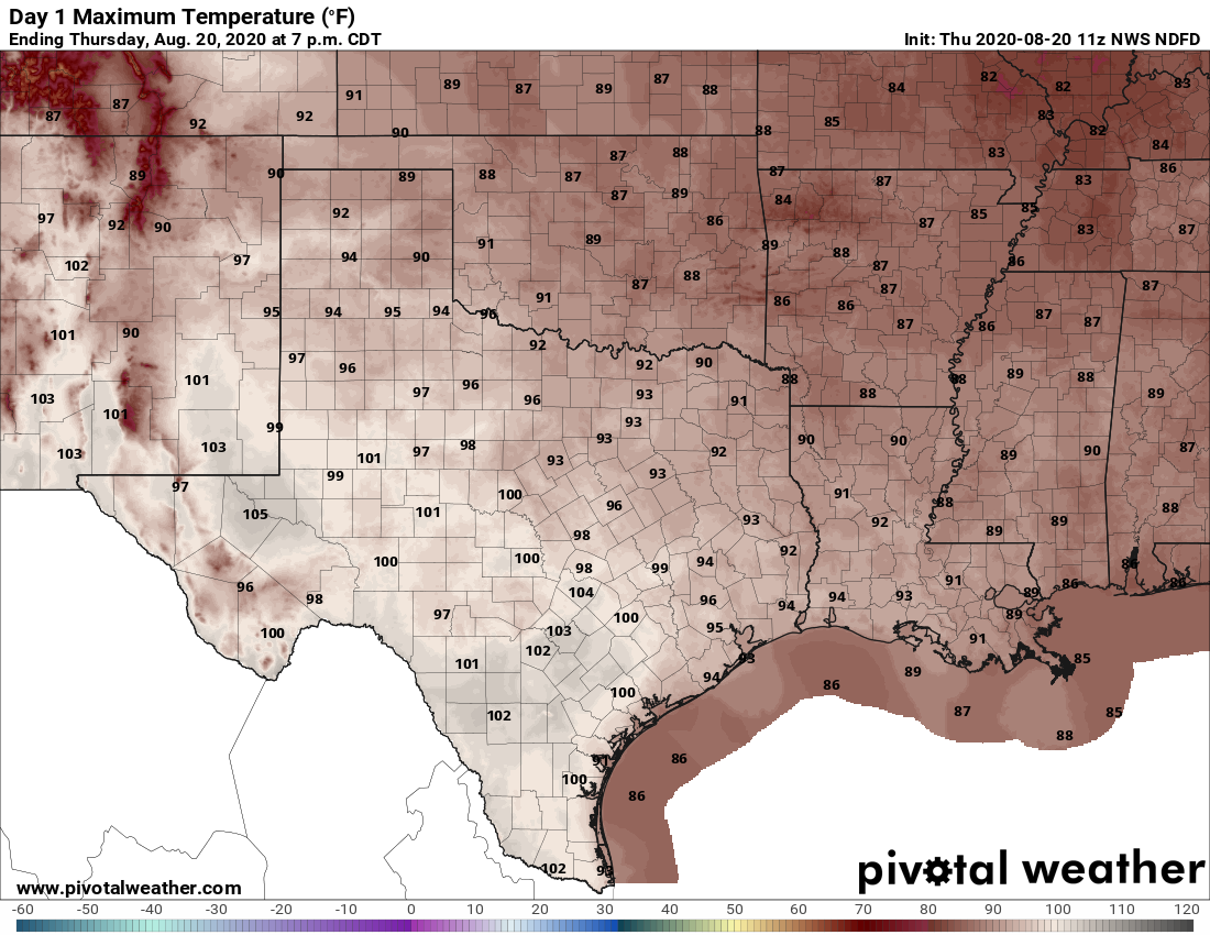
Look for highs in the middle or upper-90s and lows generally in the 70s through Monday morning.
Monday and beyond (or the TD 14 discussion)
Alright, on to the main event. There is good news and bad news today on the Tropical Depression 14 front. The good news is that the storm is not any better organized this morning. The bad news is that because the storm is not any better organized this morning, we remain with more questions than answers.
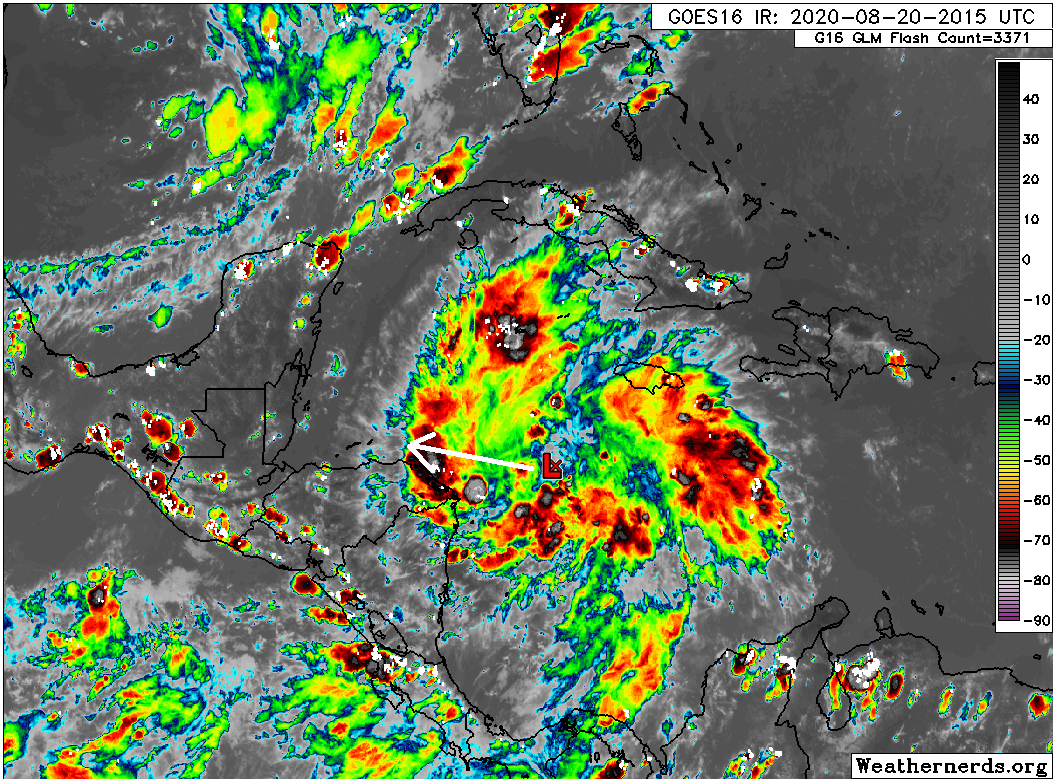
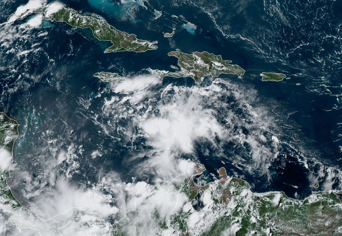
Let’s start with a satellite loop of the system this morning.
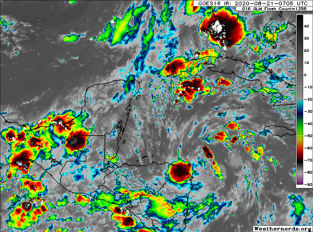
Most folks will look at that loop and basically see a “swirl,” which is what you expect, even if thunderstorm coverage is a bit sparse. Well, the “swirl” is actually in the mid-levels of the atmosphere, not at the surface. At the surface, which matters greatly for the future of this thing, the National Hurricane Center (NHC) says that satellite passes and earlier reconnaissance aircraft data can’t really hone in on one defined center. Broadly speaking, this means TD 14 is disorganized this morning. That’s a good thing, of course, but it’s also a tricky one because without a defined starting point, you degrade the forecast of your ending point, thus increasing uncertainty in the forecast after a day or two.
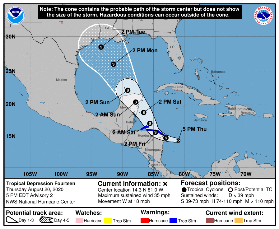
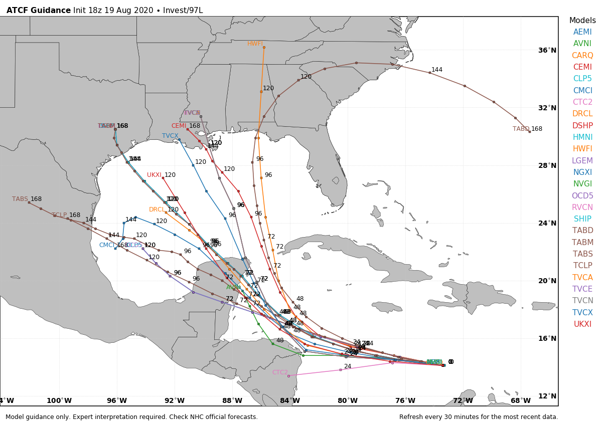
Let’s look at the official NHC outlook as of 4 AM CT.
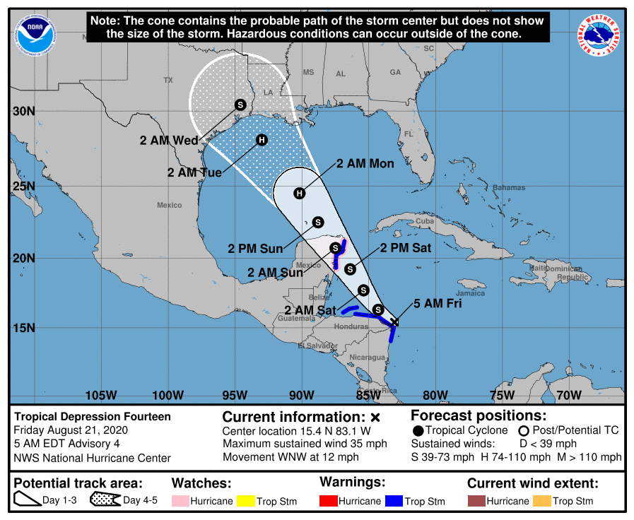
The NHC track remains pointed right at Houston, and the wrinkle overnight was that it explicitly shows a hurricane in the Gulf as it approaches. How do you interpret the map above? While the forecast shows the track pointed at Houston, by day 5, the reality is that the center could be anywhere from near Matagorda Bay to perhaps near New Orleans. We always say “look at the cone, not a point on a map.” You really need to take that advice with this system, because there is an inordinate amount of uncertainty still today.
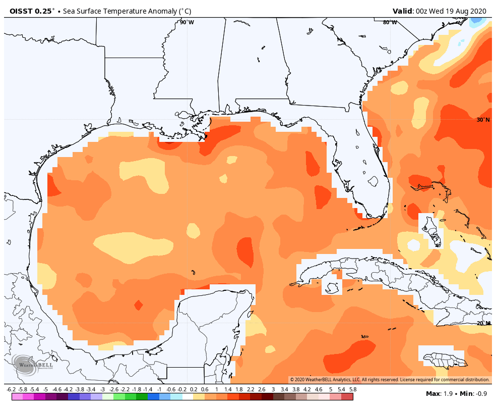
We know that TD 14 will emerge in the Gulf on Sunday. It will probably be a tropical storm at that point, but given the current situation off Honduras, that’s not a guarantee. It may be weaker. Over the Gulf, it should find some opportunity to strengthen a bit given very warm water temperatures (as noted yesterday afternoon).
But there are three significant hurdles that will impact how TD 14 may or may not strengthen and track.
1.) Wind shear: We know wind shear is expected to be low as it emerges in the Gulf. But per the NHC, it’s expected to increase in the northern Gulf. According to the SHIPS model, by late Monday or Tuesday, shear is around 15 to 25 knots. That’s not massive, but it’s enough to give a tropical system some problems. Alternatively, there is some risk that the wind shear will lessen or focus more inland. In that case, it may actually help TD 14 to strengthen a bit as it approaches land. This remains a difficult item to pin down, but the going theory is that TD 14 will have to fight some wind shear as it approaches Texas or Louisiana.
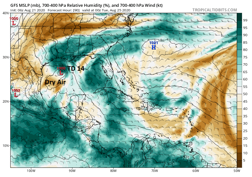
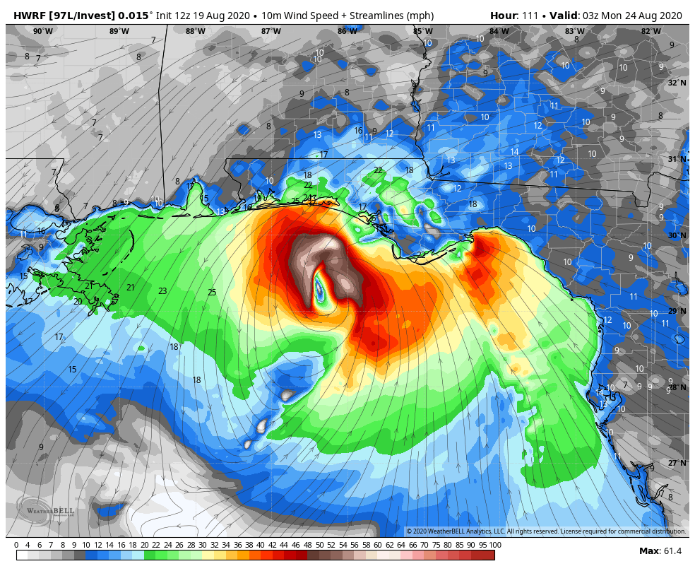
2.) Dry air: If you look at the GFS model on Monday evening at 7 PM, you’ll see TD 14 probably as a moderate tropical storm in the Gulf. If you look at relative humidity on the GFS model, you’ll see the storm is lopsided with the best moisture north and east of the center and a pretty significant amount of dry air south and west.
We have had some lower humidity than usual lately here, right? You’ve felt that. It’s still plenty hot, but dewpoints (at IAH) have been as low as 59 degrees in recent days! That’s really, really comfortable for Houston in summer. And rare too. That’s the first time that has occurred in August since 2015, and of the 7,180 August hours in the last 10 years, only 20 (0.25%) have had air that dry. Well, dry air is going to linger a bit longer, and it would seem that it will impact TD 14 in some capacity. Could TD 14 fight off dry air? Sure, but it better get its act together quickly if it can become robust enough a storm to accomplish that feat.
3.) Tropical Depression 13: One of the most common questions I’ve seen from people is some variation of “Could TD 14 merge with TD 13 as it comes into the Gulf and create a Category 6 megacane, which would be soooo 2020!?”
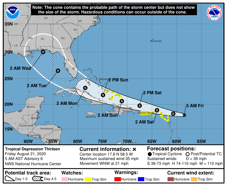
Here is the forecast track of TD 13, by the way:
The answer to that one is complicated. For the sake of time and simplicity, I’ll be brief here. There is a meteorological process known as the Fujiwhara effect. You can read about it here. In a nutshell, if two tropical systems get within about 800 miles of each other, one can impact the circulation of the other. The diagram below shows this in the case of a much stronger storm. In this case replace Bopha with “TD 14” and Saomai with “TD 13:”

In an idealized Fujiwhara situation (unlikely), what would likely happen is that TD 13 would move into the Gulf from south of Florida, and as it comes north, TD 14 would probably slow down offshore of Texas or Louisiana, allowing 13 to go inland (likely to our east) and 14 to meander for a day or so offshore before going inland too. Now, to be clear, this is not the base case; it’s not what we expect. However, there could very well be some element of interaction that occurs between TD 14 and TD 13 because of their expected proximity to one another. That would depend on strength, orientation, etc. And since we don’t really know those things right now, it’s difficult to say how that interaction will (or will not) occur. We have also never seen that before in the Gulf. Like, ever. We have had simultaneous systems in the Gulf, but they’ve never been close enough to each other to risk that sort of interaction. In that respect, this is basically unprecedented and there will be unknowns.
So to summarize: It is likely that TD 14 will enter the Gulf Sunday and strengthen, possibly to a hurricane, tracking broadly toward Texas or Louisiana. The Houston area is very much in the cone, and we’d advise folks to continue to prepare as if a hurricane were coming. There are some hurdles for TD 14 and numerous things we do not yet know, however, and impacts could realistically range from hardly anything to a full-blown hurricane in our area. Eric and I will keep you posted through the weekend.
Quick note on rainfall: While we’re trying to figure out the tropical side of this thing, we are obviously sensitive to people’s concerns about rain, flooding, and a Harvey stall type scenario. Right now we do not expect a “stall” situation. No reliable model is hinting at that, and there’s nothing in the data right now that would argue that it’s a serious concern. The storm may slow down a little as it moves through, but slowing down is not equivalent to stalling and the differences are significant. We expect heavy rain, particularly if the storm comes in more to the southwest of Houston, and flooding is always possible in tropical systems. But we are not especially worried about any one possible outcome at this time. We will update you on the rainfall aspect more this weekend as things become clearer.
Special note: Today, at 1 p.m. CT, Eric and I will be conducting a Facebook Live to provide up-to-date forecast information, and answer your questions about what to expect from this tropical system. This event is sponsored by Reliant.
