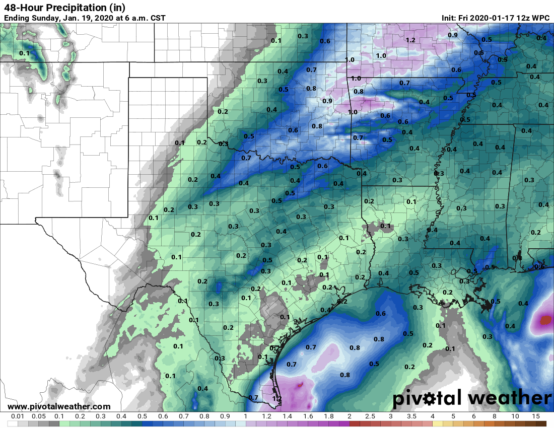
Mostly quiet weekend for Houston

Good morning, and welcome to another Friday. Before we get into the forecast, I wanted to bring your attention to an event that was held yesterday at Rice University. “Flooding, water reuse and resource recovery: Trends and opportunities” was held at the Baker Institute at Rice. They were planning to discuss water use issues initially. But post-Harvey, they put together a good panel including Jeff Lindner, Harris County’s Flood Control meteorologist to discuss Harvey and some of the issues around flooding. I encourage you to watch the presentations, which can be accessed from the event web page. After the three presentations, there was a Q&A period. This is one of many conversations that will need to continue in the wake of Harvey.

One other quick note. I’ll have a long post later this morning that will recap the incredible tornado outbreak that accompanied Hurricane Harvey here in the Houston area. So far, the National Weather Service has confirmed 29 tornadoes in the Houston area. We’ll drill into some of the bigger ones and ones we have damage pictures from. Look for that around 10 AM.

On to the forecast…

Friday & Weekend

This weekend should be fairly straightforward. We should be dry once again today. We hit the low 90s on Thursday, and we’ll probably hit that or exceed it again today. Aside from the heat and humidity, it will be sunny.

For Saturday and Sunday, not a ton of change, but there will be some subtleties. Precipitable water values will edge upwards from just over an inch today and Saturday to around 1.5″ to 1.75″ on Sunday. Don’t worry, that is not abnormal for this time of year. It does mean that we should see at least a few showers and perhaps isolated thunderstorms around each afternoon, particularly on Sunday. Another don’t worry moment: The rains won’t be widespread, and they shouldn’t be too heavy either (and many areas will stay dry). But don’t be shocked or alarmed if you see some showers around this weekend.

See full post

Back to regularly scheduled late summer

Admittedly, it was probably too good to be true to think we could get through September with completely pleasant weather. The weather pattern over most of the United States is actually going to make a pretty significant shift from where it’s been since early August. This means typical late summer weather for Texas. On to the details.

Today & Friday

While both today and tomorrow will be on the hotter side, it will actually be rather nice still. Yes, there will still be some haze around unfortunately. But it will be mainly sunny, with fewer clouds today, and we’ll keep that up into Friday. High temps will peak in the lower 90s, with morning lows in the lower or middle 70s. Rain chances are near zero both days.

Weekend

Expect similar temperatures this weekend, with highs in the lower 90s and nighttime lows more in the mid-70s perhaps. The warmer nights are courtesy of increased humidity, which will also signal our first chance of showers this month. Yesterday was our 14th straight day without rain. Given Harvey, you couldn’t script that any better, but of course it will still eventually rain again in Houston.

Rain totals through Monday morning should be spotty and minor. (NWS/Weather Bell)

Rain totals this weekend should be extremely modest, a tenth to a quarter inch on average. Many of us won’t see any rain at all. The better chance of the two days will be Sunday.

See full post

Summer lite returns to Houston, and it will remain awhile

Nine years ago today, Hurricane Ike made landfall along the northern end of Galveston Island. Of a hurricane’s three major threats—damaging winds, storm surge, and inland flooding—Ike’s greatest damage came from its surge along the coast. In the nearly decade since then, we’ve done nothing to mitigate the problem of surge. It would be a great shame if we make the same mistake with regard to inland flooding after Hurricane Harvey.

An aerial photo of damage in Gilchrist, Texas, after Ike. (FEMA)

Now, onto the forecast.

Wednesday through Friday

Southerly winds are back, and with it comes increased humidity and warmer nights. Overnight lows this morning are nearly 10 degrees warmer than just 24 hours ago. We won’t see too much of a difference in high temperatures over the next several days, with the mercury climbing to about 90 degrees or so. But it will feel warmer, given the increased moisture and humidity. This is more typical weather for September.

See full post

End of Texas tropics season may be near as Houston warms back up

Well, it has been a busy few weeks in the tropics with hurricanes Harvey, Irma, Katia, and now Jose meandering around the Atlantic Ocean. (Speaking of Jose and its track forecast, while the 75-mph storm may move back toward the US East Coast this weekend or early next week, as of right now it most likely will stay offshore). Perhaps not surprisingly, the Atlantic season reached its “peak” of activity on Sunday. As you can see, however, a good bit of activity historically continues into early November.

Graphic showing frequency of hurricane activity in the Atlantic Ocean. (National Hurricane Center)

But for Texas it’s a different story. I am not ready to declare an end to the Texas hurricane season, but long-time readers will recall that after Sept. 24th the chance of a hurricane hitting the state are historically quite low. Moreover, forecast models show little to no tropical activity in the Gulf of Mexico for at least the next week or 10 days. So we’re getting close to that date, and after Hurricane Harvey we’ve certainly had enough of the tropics for awhile. I’ll post later this month when I think we’re all clear on the tropics front.

Now let’s take a look at our forecast for the next week.

See full post