After more record warmth on Tuesday—Hobby Airport set a record high of 89 degrees, breaking an old mark of 87 degrees—a cold front finally pushed through the region during the late evening hours. Fall, finally, has returned to Houston for awhile.
Wednesday
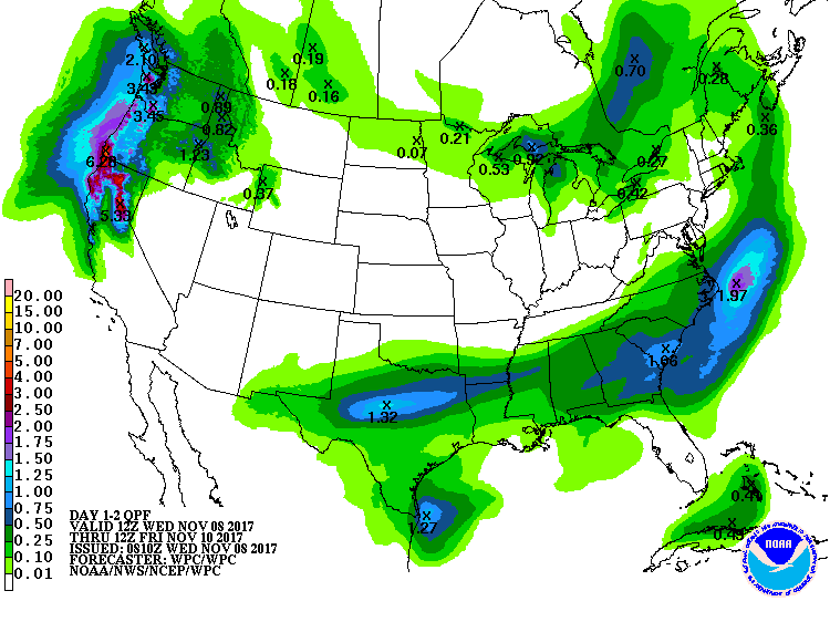
Today will be cool, with highs in the low- to mid-60s, with increasing rain chances this afternoon and evening. An upper-level disturbance will track from west to east across Texas today, and this should bring some decent rain chances to us, especially for areas north of Interstate 10. Overall, accumulations still look pretty slight for Houston, with most areas getting a tenth or two of an inch of rain, but the leaden skies will add to what will be a winter-like, gray day for Houston.
Rain accumulation forecast for Wednesday and Thursday. (NOAA)
Thursday and Friday
These days still look like the pick of the litter for the region, with partly to mostly sunny skies, and highs in the upper 60s to 70 degrees. Overnight lows should range from the upper 40s for inland areas to upper 50s closer to the coast. Just splendid fall weather.
Houston continued to set record high temperatures on Monday—a mark of 89 degrees at both Bush Intercontinental and Hobby airports broke records at each location by a degree. Fortunately, this abnormally warm weather for November will finally come to an end later today, or tonight.
Today
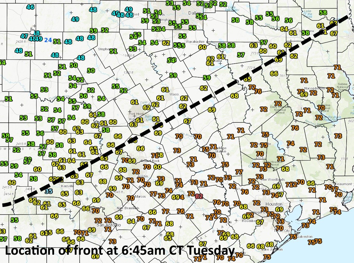
We’ll have one more day with temperatures in the upper-80s across the region before a cold front pushes into Houston. As of 6:45am CT, the front was draped across Central Texas, and slowly pushing to the southeast. Temperatures (and especially dewpoints, which denote drier air) are considerably cooler behind it.
Cold front location at 6:45am CT on Tuesday. (National Weather Service)
The front is moving a bit faster than expected, so it should arrive in the Houston area later this evening, and push off the coast by midnight, or shortly thereafter. Before then, we’ll be partly to mostly cloudy, and unseasonably warm. Afterwards, cold.
Note: We’re kicking off our annual fundraiser today, in which you can buy t-shirts to support the site, or donate money if you like. This is strictly optional, but it helps keep the lights on here, and supports the efforts of Matt and me during extreme weather events like Hurricane Harvey.
Houston experienced some very warm weather this weekend, both during the days and sticky nights, with the following records set or tied:
Saturday high temperature: Houston Hobby Airport, 88° (tying old record from 1988)
Sunday high temperature: Houston Bush Intercontinental Airport, 88° (tying old record from 1963)
Sunday, high minimum temperature: Houston Bush Intercontinental Airport, 74° (beats old record of 71° from 1922)
Sunday, high temperature: Hobby Airport, 90° (beats old record of 87° from 2005)
Sunday, high minimum temperature: Hobby Airport, 75° (beats old record of 71° from 2015)
Monday and Tuesday
We’re going to remain in this stagnant, muggy, and decidedly un-fall-like weather pattern for a couple of more days before a cold front finally breaks the region out of this funk. On Monday and Tuesday look for highs in the upper 80s for most of the region, with partly sunny skies. We should also continue to have warm nights before the front arrives.
Let’s be honest, it could be cold, pouring, snowing, whatever and Houston would find a way to enjoy today. So whatever we have to say about the weather, it’s a fine day for a parade. Lots of other things going on this weekend too. Let’s hop to it.
Today
So, overall today shouldn’t be too bad. Expect a mix of sun and clouds with high temperatures in the middle 80s. We managed to hit 88° officially yesterday, which is the 9th hottest November day on record in Houston (the other 8 days we hit 89°). Last time it was this warm in November officially? One year ago. We hit 88° on November 2nd and 3rd of 2016. Hobby Airport hit 90° Thursday, tying their warmest November temperature on record (1934 and 1973 being the last years to see 90° at Hobby). Further north, Dallas hit 94° yesterday, breaking their previous all-time (back to the 1890s) hottest November day by *five* degrees. If you’re wondering if this is unusual for November, it is.
Anyway, with a pretty weak little disturbance passing through North Texas today, we will probably see a smattering of isolated showers this afternoon. I don’t expect them to be significant in coverage or intensity. If you’re headed to the Astros parade downtown, I wouldn’t necessarily expect rain, but I wouldn’t be shocked if it did rain for a few minutes.
Weekend
The weather pattern for the next several days looks pretty stable over Southeast Texas. This should yield a mix of sun and clouds both days. Don’t be shocked if clouds are prevalent in the morning, before breaking up in the afternoon. Also, morning fog, locally dense, is likely the next few days, so use caution if you’ll be out and about early in the day. Temperatures will top off in the middle 80s inland. I wouldn’t be shocked to see an 87°, 88°, or 89° show up though in a few spots on either day.
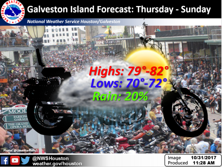
In Galveston for the Lone Star Rally? It looks just fine. Expect low 80s for highs both days. Morning lows will be in the mid-70s in Galveston.
Fine weather this weekend for the Lone Star Rally (NWS Houston)
Elsewhere, morning lows will be in the low 70s on average. We should typically be in the 50s right now.
Oh, and rain chances? They aren’t zero, but they are very, very low for most areas to the point that we wouldn’t even bother mentioning them. Go about your plans without much worry this weekend.
By the way, Houston’s other postseason team, the Dynamo play the Timbers out in Portland Sunday at 6:30 for a chance to advance to the Western Conference Championship. It looks like a typical early winter day in Portland for the match: Damp, though perhaps not raining too heavily, with temperatures in the 40s. So let’s keep the championship vibes flowing.