Tuesday morning Harvey forecast update

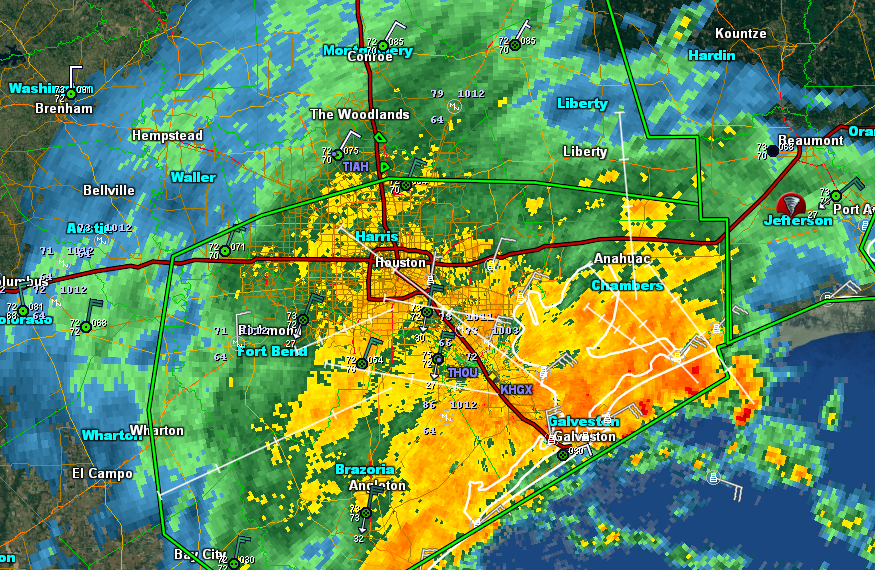
Tuesday, 6:20am CT— Good morning to all. Day four of Harvey in Houston is well underway. The end of the rain part of the storm is closer yet. For those curious about specifically how much rain has fallen, the National Weather Service did compile a brief list. Mutliple locations are over 40″ of rain total, especially southeast of Houston. Other locations have ranged from a lot to an awful lot.

Now

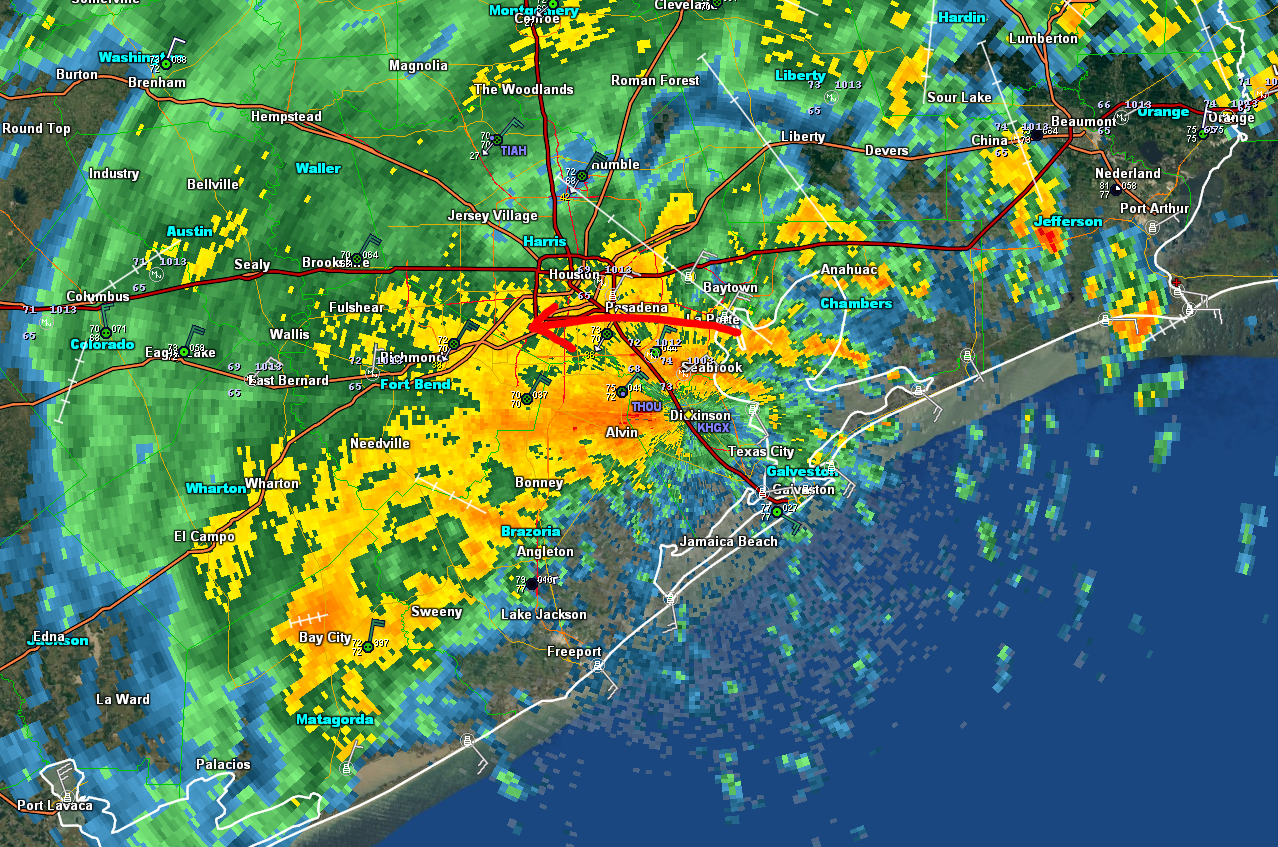
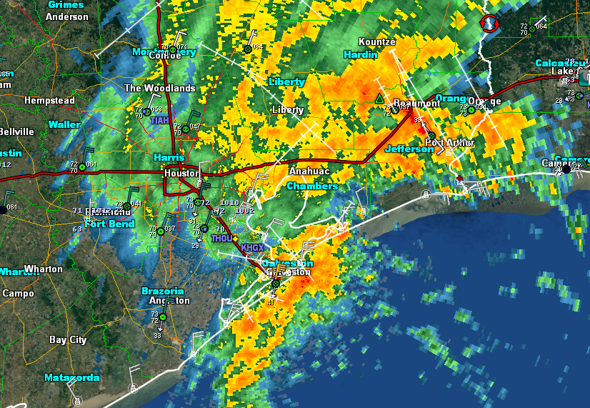
After a night of more rain, things have calmed down a bit in many areas this morning. Most rainfall rates are under 0.50″ this morning, except perhaps in the northeast corner of Harris County, and parts of Liberty, Chambers, and coastal Galveston Counties.

Radar as of 6 AM shows continued light rain in much of the area, with some more moderate rains east of I-45 and near the coast. (GR Level 3)

Any breaks are welcome of course, but we still have a little bit of a ways to go in this storm.

Today

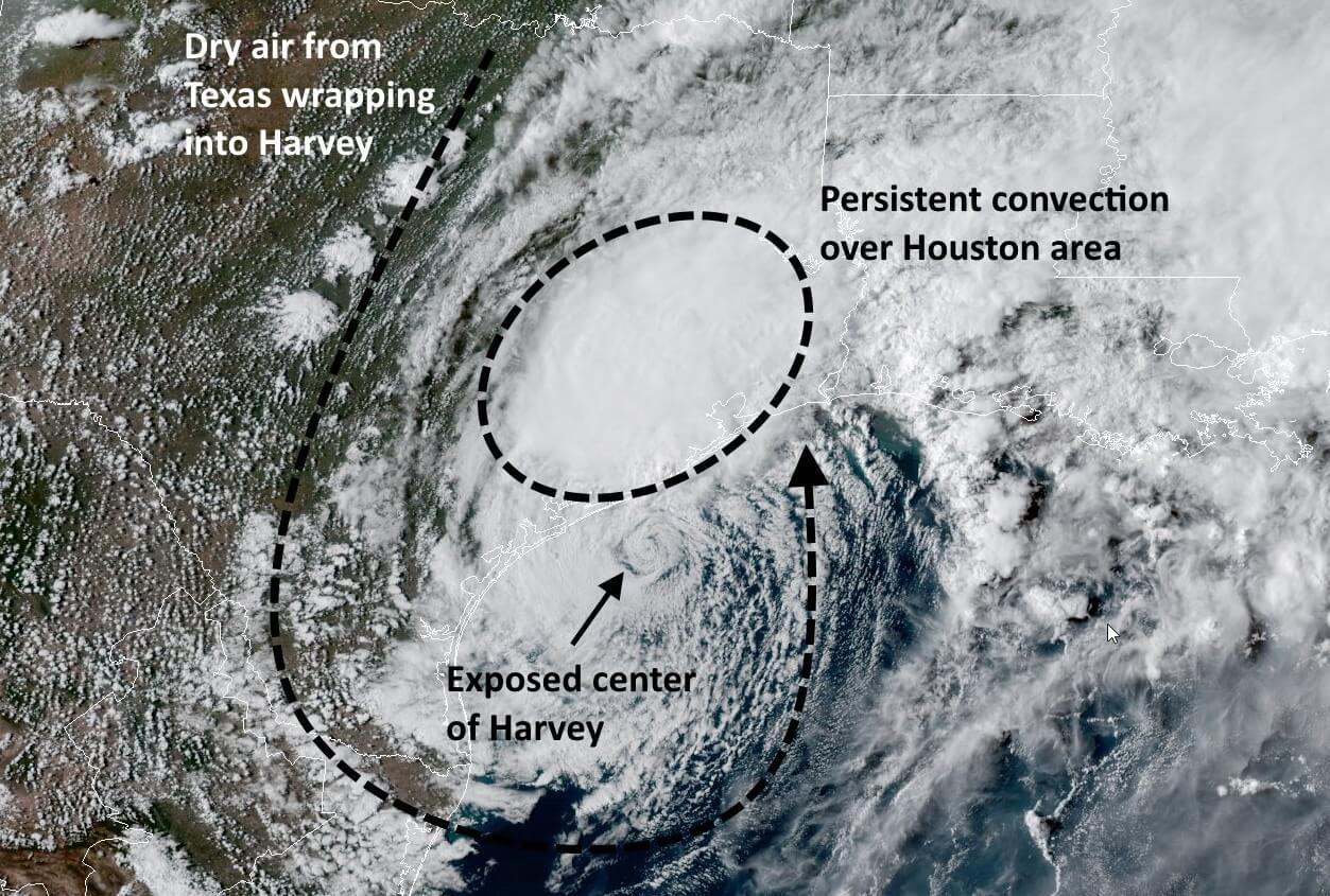
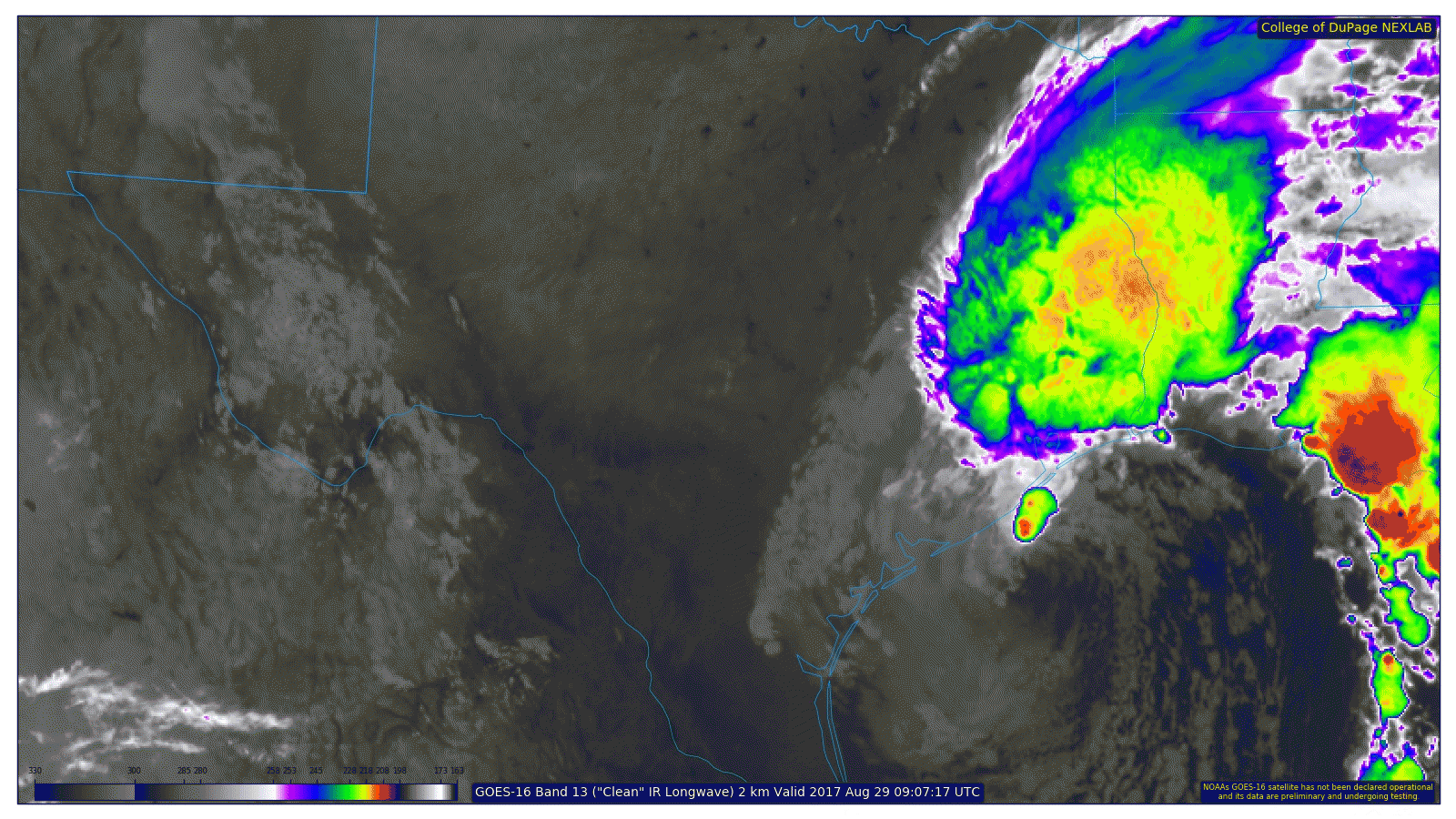
Models seem to be struggling a bit handling the current situation, either overdoing it or underdoing it, so there’s a degree of uncertainty in the forecast today. If we look at a satellite loop this morning, the brightest clouds on this loop (essentially indicating the most moisture for thunderstorms) are clearly east of the area.

Harvey’s most intense weather should stay to our east, but I don’t believe we’re done with occasional moderate to heavy rains yet. (College of DuPage preliminary, non-operational GOES-16 data)

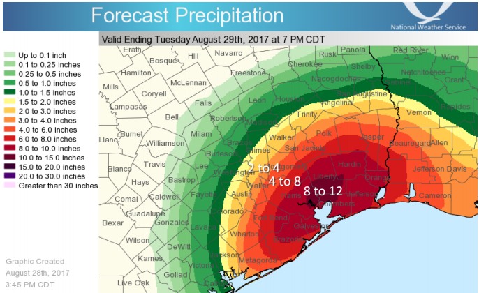
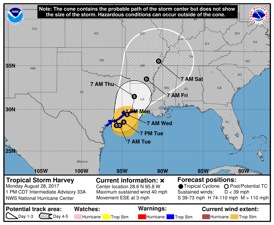
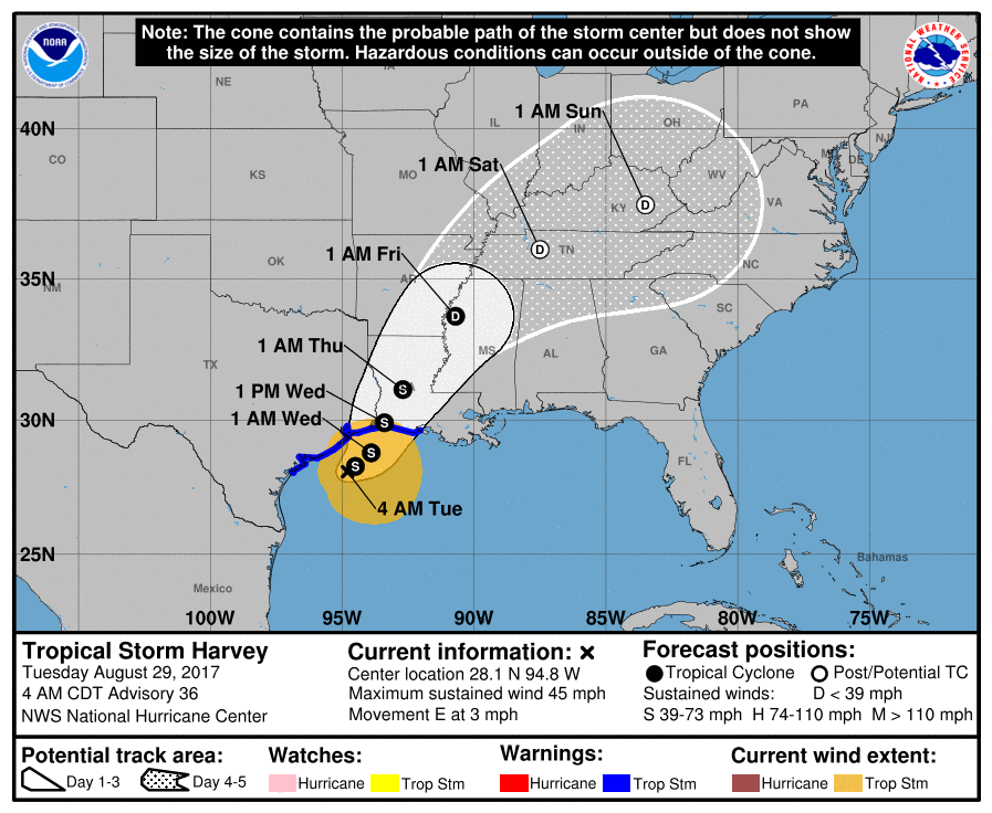
If you look offshore, there remains a little cluster of heavier storms on the north side of the center of Harvey (still a 45 mph tropical storm). Harvey’s eastward drift should become a northeasterly one later today. As this happens, it will probably fling back another wave or two of rainfall into the region, similar to yesterday or somewhat similar to last night. The heaviest rains will be east of I-45, while lighter rains will continue west of I-45. We should add up to a couple more inches at most west and perhaps 2-4″ (perhaps a few higher amounts in spots) or so east through the day today.

Tonight and Wednesday

As we go into the final phase of Harvey, and it begins to pull away tonight and Wednesday, we should see periods of rain once again, lightest west, heaviest east. Those should add up to another 0.50-1.50″ west of US-59 tonight through Wednesday evening and another 1.50-4″ east of US-59 and north of I-10. Some places will see less, others more, but this is about the average of what we should see.

Harvey’s turn north begins today and begins to accelerate tomorrow. (National Hurricane Center)

The forecast for Wednesday night would have steady rain ending east of Houston, and Thursday should see just a few scattered showers. Friday and Saturday continue to look dry.

We’ll have more the forecast and flooding later this morning. Stay safe all.

Posted at 6:20 AM Tuesday by Matt

Late Monday evening Harvey forecast update

Monday, 9:55pm CT— Our torment continues, as rain, albeit far less intense than what we’ve experienced at times since the weekend, continues in another soggy night around Houston.

Now

There’s no good news here, but if we want to try and spin things positively tonight, we can say something at least. Areas west of Houston, where rains flow into the already full Addicks and Barker Reservoirs are seeing relatively lighter rains compared to the rest of the region. The rate of rainfall is averaging about 0.50″ to 1.50″. Of course, areas east do not need the rainfall either. For every action, there’s an equal and opposite reaction unfortunately. Again, areas already in flood continue in flood, and the combination of rain and wind prevents much rapid drainage to improve conditions elsewhere.

Harvey continues dumping steady rain over the Houston area. (GR Level 3)


Rest of Tonight

Unfortunately we don’t see this rain ending tonight. In fact, the situation may be rather steady state much of the night. Rain will fall at varying levels of intensity. The heaviest will be south of I-10 and east of I-45. Rates will remain in this 0.50″ to 1.50″ per hour rain most of the time, but every so often it could ramp up to 2″ per hour or ease back to 0.25″ per hour. Winds will continue to gust at times to 25 to 35 mph, perhaps down a little from earlier today, but still enough to produce occasional, scattered power outages. CenterPoint is reporting about 96.02% of customers with power tonight, which isn’t substantially changed from earlier today.

Tuesday

We’re almost to the end of this terrible movie, but we have one more day to get through. Analyzing data this evening, it appears steady moderate rains will continue much of Tuesday. Similar to tonight, it could be heavy at times, lighter at others. The trend will be toward slightly more sporadic rains and hopefully slightly lighter ones too. I suspect that trend will continue into tomorrow night.

Wednesday and Thursday

Harvey finally exits to our north on Wednesday. Rain should taper to showers from south to north and end through the day. Yes, the rain will end. Finally. By Thursday, there may still be enough instability around for scattered showers or storms, but they’ll be very hit or miss (many of us dry, others see a shower or two). And I think we’ll see some sunshine here.

We’ll keep you posted through to the end of Harvey and beyond. Be safe all.

Posted at 9:55 PM Monday by Matt

Harvey Monday evening forecast: It’s not a great one

Monday, 6:15pm CT—It’s been a wet day across an already waterlogged Houston, and unfortunately we can probably expect similar conditions to continue through the night. During the day we have seen a lot of dry enter into Harvey’s circulation along its eastern side, but unfortunately this has yet to substantially affect the convection on Harvey’s northwest side—which just happens to be continuously dumping rainfall on Houston.

Harvey’s satellite appearance at 6pm CT. (NOAA)

This pattern has allowed Harvey to drop 3 to 8 inches of rain across most of the Houston metro area during daylight hours today, with the heaviest rains in northern Brazoria County and Southern Harris County.

Because Harvey is only moving to the east-southeast very slowly, about at the pace of a slow walk, we can probably expect this pattern to continue for tonight, and into Tuesday morning. For the most part these aren’t excessively heavy rains, but even rainfall rates of 1 inch an hour will cause bayous and floodwaters to rise if they persist long enough. Therefore, while we don’t expect floodwaters to rise rapidly tonight, steady, moderate rains could cause slow rises in bayous. This is about exactly what the Houston region doesn’t need right now.

As far as accumulations, the National Weather Service predicts that the following areas of Houston could get as much rainfall as the amounts shown in this graphic during the next 24 hours, through 7pm Tuesday. I’m hoping these totals are little high, but we can’t rule them out.

Rain accumulation forecast for 7pm Monday to 7pm Tuesday. (National Weather Service)

Looking for some good news? We have a little bit of that. The favorable area for tornado formation is moving to the east, so we should have fewer tornado warnings tonight, and then fewer to none on Tuesday. Also, we feel fairly confident that the potential for prolonged, heavy rainfall will end sometime on Wednesday, during the afternoon or evening hours.

Matt will have another update later tonight.

Posted by Eric at 6:15pm CT on Monday

Early Monday afternoon Harvey forecast update

Monday, 2:15pm CT— Good afternoon. After our break last night, rains have returned to the picture this morning and afternoon. Any rain adds insult to injury right now, but at least the rainfall rates have been, for the most part, under 1.50 inches per hour. This is small comfort obviously, but versus the rates we saw on Saturday night and Sunday, the word “manageable” keeps coming up. As manageable as something can be in this situation.

Now

As of 2 PM, radar is active, with steady moderate to locally heavy rainfall across the southern half of the Houston metro area.

Weather radar as of 2 PM is not optimal. (GR Level 3)

North of I-10 is seeing steady light to moderate rain persist as well. Rainfall rates as of 2 PM are about 0.25″ to 0.50″ per hour north of I-10 and 0.50″ to 1.50″ south of I-10. Again, insulting, infuriating, frustrating, but mostly manageable. It just really slows down drainage. Steady northeast winds inland and southeast winds at the coast are not helping matters either. There have been gusts to 40 or 45 mph, and that looks to continue, although significant increases beyond this are unlikely.

Rest of Today

What you see is what you get. Expect this rain to stay in place much of the afternoon. Rain may fall heavily at times, especially south of I-10. Winds will stay occasionally gusty. Wish we had better news on this front, but it’s going to be a pretty miserable Monday, and hopefully the rates stay at this manageable level. We feel they ought to.

Tonight and Tuesday

I don’t expect a lot of change tonight. Rain will likely fall steadily through the night, and into Tuesday morning. Harvey’s general east or southeast movement will pretty much lock things in. As Harvey begins to shift northward on Tuesday, we will start to see the rain become a little more sporadic I think. Steady moderate rain much of the time Tuesday morning into the afternoon. Harvey should make another landfall Wednesday near High Island, TX as a weak to moderate tropical storm (no significant strengthening is likely).

Official NHC forecast is not changed much, with our horrible storm finally exiting on Wednesday. (NHC)

This remains first and foremost a rain issue, and you should continue to monitor the water. Steady rain should end Wednesday and daily storm chances trend to close to zero by Thursday. We should see sunshine and much better weather to end the week, and we can begin our road to recovery. Stay safe all.

Posted at 2:15 PM CT Monday by Matt