Hurricane Irma reaches Keys, will bring disaster to Florida

When it comes to measuring the intensity of hurricanes, the most widely understood metric is sustained wind speed, and this morning Irma has regained some strength, to 130 mph. However for scientists, the more accurate determinant of intensity is central pressure—the extent to which a storm’s center is lower than the Earth’s normal sea-level pressure of 1013.25 millibars. This morning, Irma’s central pressure has been hovering just below 930 millibars. Although far from a record, only six US hurricanes have made landfall with pressures below this—The Indianola storm, the 1919 Florida Keys hurricane, the 1935 Labor Day storm, Camille, Andrew, and Katrina. All are legendary storms. This provides some sense of what is now crossing the Florida keys and moving toward the Florida peninsula.

Intensity and Track

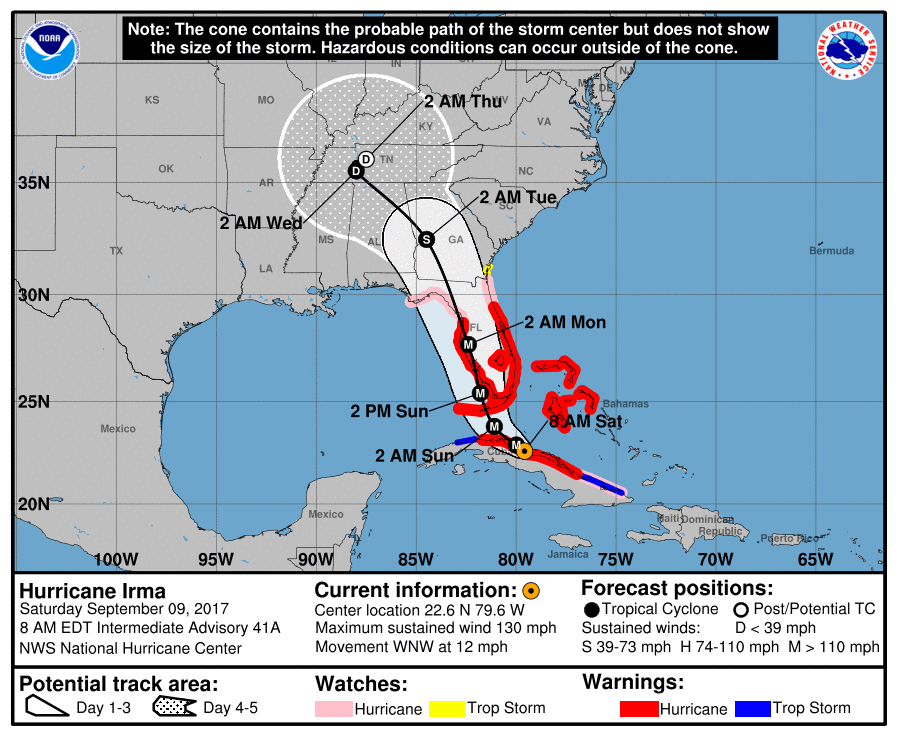
Irma finally turned to the north-northwest on Saturday night. While the delayed turn was a surprise to some, we have been discussing the possibility of Cuba-then-southeastern Gulf of Mexico scenario since last Tuesday. The Cuba interaction weakened Irma substantially, from 160mph down to 120mph, but since moving back into the Florida Straits on Saturday afternoon, the storm has begun to regain some strength, to 130mph as of 7am CT Sunday.

Irma will now move through much higher wind shear than it has seen for days. (CIMSS/Space City Weather)

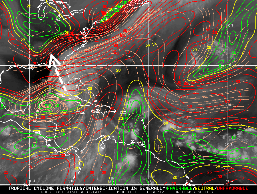
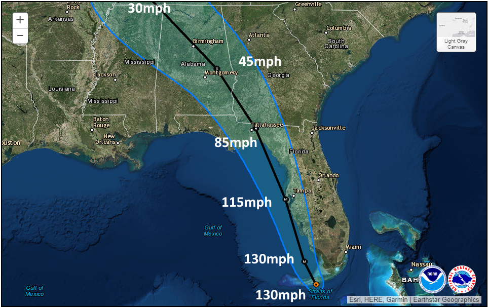
Fortunately, the window for restrengthening is short. Later today Irma’s center will begin to interact with the southwestern part of Florida, and this will disrupt the storm’s organization. Another critical factor is wind shear, the varying direction of wind speeds at different levels of the atmosphere. Irma has had a very smooth go of it for days (less than 20 knots). But it has now reached an area of higher shear (shown above), and this should help to weaken the storm considerably over the next day. Here’s the official forecast for winds over the next three days as Irma moves inland.

Forecast maximum sustained winds for Irma. (National Hurricane Center/Space City Weather)

See full post

Saturday Irma Update: Cuba, Keys, and beyond

As of 7:30am CT on Saturday, Hurricane Irma continues to move westward, with its center just inland over the northern coast of Cuba. This more westward track, taking the storm over Cuba, is a scenario I discussed a couple of days ago—the Cuban—which would spare the Miami area the worst effects of Irma.

The track over Cuba has weakened the storm’s maximum winds to 130mph, and additional weakening is possible before Irma moves back into the Straits of Florida later today or tonight. Here’s a quick look at the official forecast track:

4am CT Official track forecast from the National Hurricane Center.

Here are the implications of this changing track:

Cuba: The island nation is being battered by the storm

Florida Keys: Still in line for a major hurricane today and Sunday. Expect devastating winds, rainfall and storm surge.

Miami area: As Irma continues to move westward, its center will bypass the Miami metro area, sparing the heavily populated southeastern coast of Florida from the worst effects of winds and storm surge. Hurricane force wind gusts are still likely, but they will probably not cause widespread damage. Inland rainfall amounts of 15 to 20 inches are possible, and flooding is a significant concern.

See full post

Hurricane Irma: What we know, and what we don’t yet know

There’s not a whole lot to say new about Hurricane Irma this evening. So far, the storm is threading the needle through the area between Cuba and the Bahamas, and heading toward the Florida Keys. The Keys face widespread damage and this near hysterical tweet from the National Weather Service is entirely appropriate.

Now that we’re about 48 hours from a final landfall somewhere in Florida we can have a fair amount of confidence in the track forecast for Irma, but there are still some important questions that ultimately will determine which parts of Florida see really bad conditions, and which see catastrophic conditions.

Cuba?

As of 4pm CT, here is the official track for Irma:

Official forecast for Hurricane Irma at 4pm CT Friday. (National Hurricane Center)

If you look closely at the hurricane center’s forecast track between now and Saturday evening, it brings the eye of Irma very close to Cuba. Recent satellite images from Friday evening show a westward movement that may, in fact, bring the center of the storm over the island for a time. If this happens, we may well see some weakening from the storm’s present 155-mph winds.

See full post

Irma’s Florida impacts unfortunately coming into focus

On the local front: All remains calm and quiet. We continue to see optimal weather to help us dry out and continue picking up the pieces after Harvey. This weather will last well into next week. Either later this weekend or on Monday, we’ll probably have to talk a bit about some potentially hotter temperatures by mid to late next week. In the meantime, the weather looks delightful for September in Texas through the weekend. Otherwise, the eyes of the weather world are focused on Irma (and also Jose, which is taking an unfortunate track near the Caribbean). Let’s start with the latest on Irma.

Irma Now

In the last 18 hours or so, Irma has been undergoing some internal reshuffling (in meteorology speak, an eyewall replacement cycle and probably some land interactions) that has caused its maximum wind speeds to drop a bit. It’s now a category four storm with maximum sustained winds of 155 mph. This is actually quite common for storms of Irma’s character. What’s been so uncommon about Irma has been its reluctance to see any fluctuations in intensity until just recently. So for all intents and purposes, Irma is now behaving like a typical high-end, major hurricane.

Irma continues to present a near-perfect appearance on satellite. This is a healthy hurricane. (NOAA)

Irma is currently west of the Turks and Caicos Islands and just north of Baracoa and Guantanamo, Cuba. It continues to move north of due west and should just graze the coast of Cuba today.

Hurricane and storm surge watches and warnings have been posted for most of South Florida.

See full post