This afternoon I wrote a post for Ars Technica on how confidence in the track forecast for Hurricane Irma is increasing now that we are only about 60 or 70 hours from landfall. Track errors shrink with shorter lead times, and the fact that the official forecast has been so consistent with a likely landfall from the Florida Keys to Miami to West Palm Beach means that there is now a high likelihood in a landfall in one of those locations.
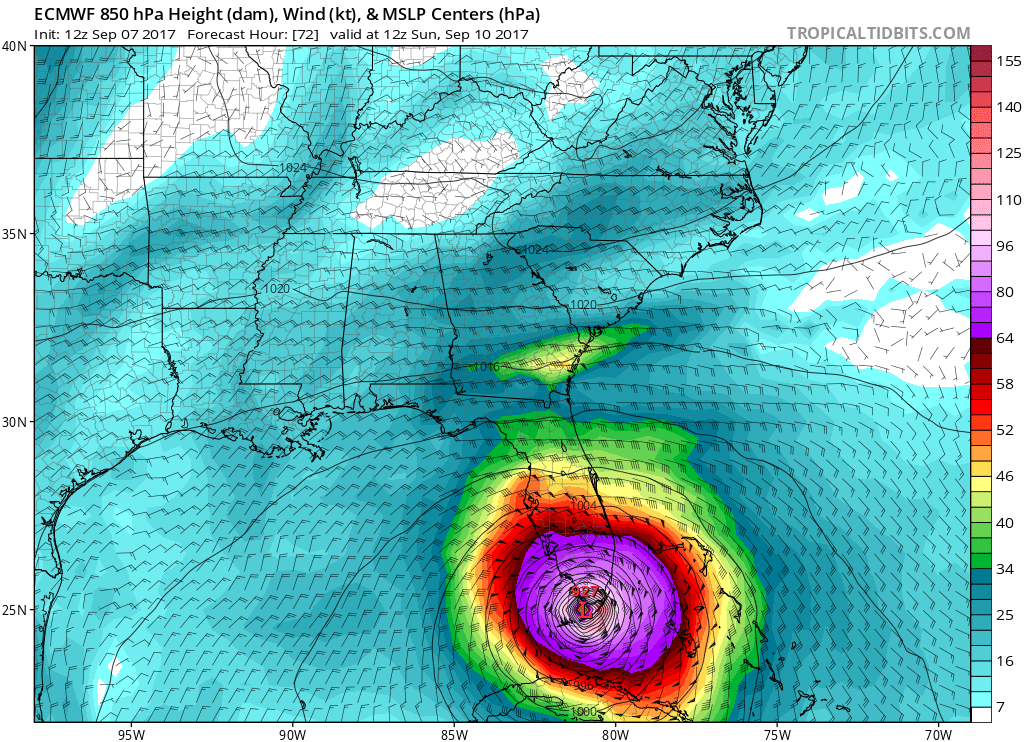
Essentially, this is a worst-case scenario for southern Florida. And this afternoon, the European model forecast had nothing but bad news for the state with the release of its 12z operational run. It made a slight shift west, with a landfall over the Florida Everglades.
12z operational run of the European model for Thursday. (Tropical Tidbits)
This is really bad, because it not only keeps some of the strongest winds over the Miami region of southeastern Florida, it also pushes a very large storm surge into the beachfront property there. I am running out of words to describe the destructive potential of this storm.
Houston’s weather will remain very fine through about Tuesday of next week. Combined with Wednesday’s cool front, a persistent northerly flow will keep highs in the mid- to upper-80s, and overnight lows in the low 60s for inland areas, and mid- to upper-60s closer to the coast. Drier air will feel great for everyone. We have no significant rain concerns for at least the next week or 10 days. Given this, for the time being, this site will continue to focus on the very active tropics, and specifically the destructive potential of Hurricane Irma.
Irma
Not a whole lot has changed with regard to the storm, or its potential track, during the overnight hours. The storm has weakened slightly, with a rise in its central pressure, and maximum sustained winds have fallen to 180 mph. Nevertheless, Irma remains an extremely intense and dangerous hurricane. Most of the forecast models bring Irma near Florida in about three days as a Category 4 or Category 5 hurricane, with the National Hurricane Center predicting a powerful storm with 150 mph sustained winds.
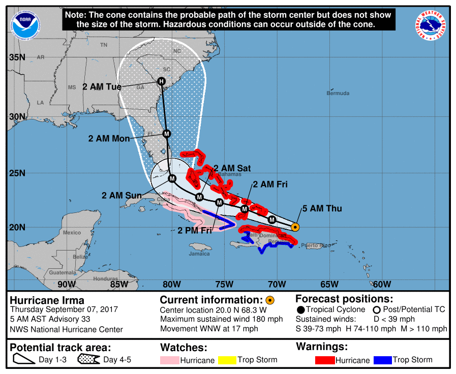
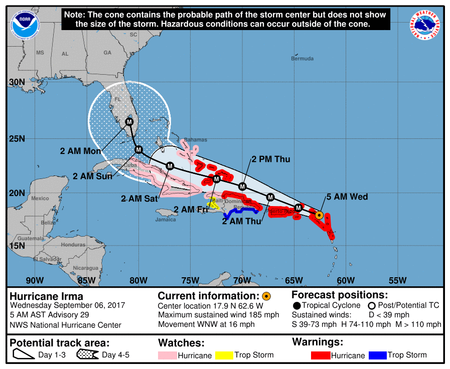
In its 4am CT track update (shown below), the National Hurricane Center didn’t change its forecast a whole lot. This keeps the landfall location squarely over Miami, and it’s difficult to argue too much with this forecast. However some uncertainty does remain, which I’ll discuss below.
Hurricane Irma official forecast, released at 4am CT Thursday. (National Hurricane Center)
Hurricane Irma remains a large, extremely powerful, and dangerous hurricane this afternoon. As one of the forecasters with the National Hurricane Center, Eric Blake noted on Twitter, “Irma has now maintained 185 mph winds for 24 hours—no Atlantic or eastern Pacific hurricane has ever stayed this strong for so long.”
Truthfully, not a whole lot has changed from this morning’s forecast, when we noted the eastern shift in some of the forecast models that kept the center of Irma east of Florida. But not the most important ones. The European and GFS models are definitely not on board with such a solution.
Before jumping into the forecast, here’s the most important message for South Florida residents with regard to Irma: A catastrophic hurricane may approach your location later on Saturday night or Sunday. The time for making final preparations is now. If an evacuation is called for your area, go. If you live in the greater Miami area, what we can confidently say from the modeling data is that there is a reasonable chance—perhaps 50 percent—that catastrophic winds are coming to one of the wealthiest, most well-developed coastlines of the country.
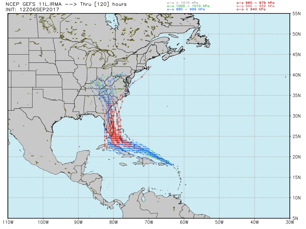
From the forecast perspective, the basic reality is that we aren’t much closer to understanding the ultimate track of Irma this afternoon than we were on Tuesday. If you’ve read this site for any amount of time, you know I like to use ensemble forecasting from the global models to make predictions—this is because ensembles offer a reasonable range of likely outcomes for a given weather event. And in looking at the most recent ensemble runs of the GFS and European models on Wednesday afternoon, there really hasn’t been much of a narrowing in Irma’s likely track this weekend.
First, the GFS model:
12z GFS ensemble model forecast for Hurricane Harvey. (Weather Bell)
Now there isn’t much clarity here, but the model does seem to be centered upon a track that will bring Irma into the Florida peninsula, or just east of the state. (Obviously the intensity of Irma when it reaches Florida is dependent upon the extent to which the storm traverses Cuba beforehand).
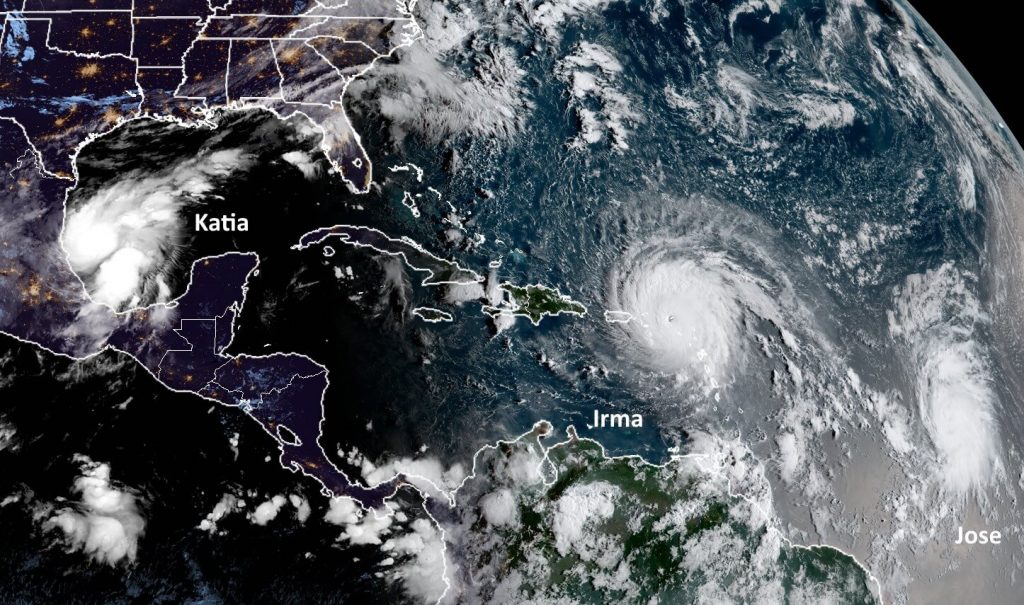
This post will provide a brief forecast for the Houston area, which really has no weather concerns at all over the next week or 10 days, and then discuss the tropics, where two other storms have developed in addition to Hurricane Irma. With 185-mph winds, Irma continues to pose a grave threat to the Caribbean Islands and southeastern United States—but the forecast is a smidgen brighter for Florida this morning.
The tropics at around 6am CT Wednesday. They are … active. (NOAA)
Houston
Some isolated showers popped up earlier this morning ahead of the cool front, and a few more may develop later this morning and early afternoon as the front moves through the metro area. Nothing to be concerned about. After this we can expect amazing weather through at least Sunday or Monday—with mostly sunny skies, highs in the 80s and lows in the 60s. High temperatures may finally get back up toward 90 degrees by the middle or end of next week, but rain chances will remain near zero.
Irma
The storm’s central pressure has continued to fall this morning (another measurement of intensity) but its winds have held steady at 185mph as it approaches Puerto Rico. The eye of Irma should pass just to the north of the island today. Here’s a look at the official forecast released by the National Hurricane Center at 4am CT:
(National Hurricane Center)
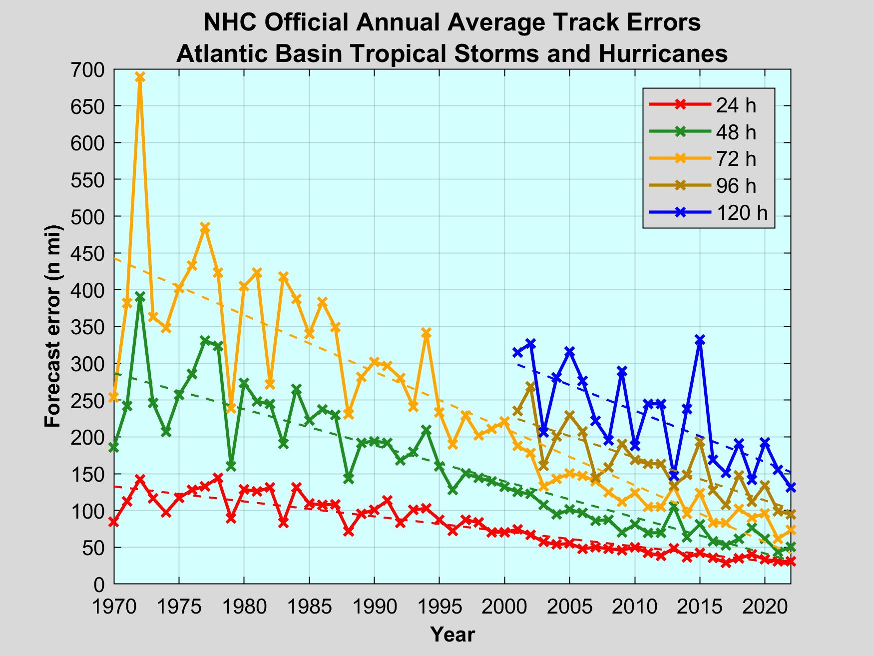
Clearly, this is a devastating forecast for Florida, essentially bringing the storm’s very worst winds and surge to an area from Miami to West Palm Beach. The storm would then continue up Florida’s spine, continuing to deliver punishing winds and waves to the eastern half of the state. However, it is equally important to note that we are discussing a forecast for conditions five days from now. Although hurricane forecasters are pretty good with forecast tracks, the average five-day error is still about 200 to 250 miles in terms of track.
