After a mostly quiet Wednesday, rain and flooding risks return today

Good morning. Wednesday ended up being a mostly quiet day across the Houston area, with the exception of a funnel cloud-producing storm near Spring in the evening.

But for most of us, it was a welcome respite after Tuesday’s mayhem. Unfortunately that break will be short-lived. As we go through the next three days, each day will have high rain chances at various times (it will not rain the entire time), and that rain could be heavy and lead to flooding once more in parts of the region, including for some places that have yet to deal with any issues. It will be important to stay tuned into the forecast the next few days.

Eric and I will keep our Space City Weather flood scale rating at Stage 3 for this event.


Just a word on this: Scales are tricky and linking historical flooding examples to a number is even trickier. Our purpose on this is to give you, as a reader, a simple sense of just how concerned we are about a flooding. Eric and I have had this on the cusp of release for months. But we have gone back and forth more than once on how to go about things. I have read some of the comments from readers, and a handful have had a tinge of confusion on some of the examples. It is absolutely critical that you, as a reader, understand that when we cite examples like Memorial Day 2015, that means different things to different folks. This scale is not meant to be interpreted as “this will be a repeat of Memorial Day 2015.” It’s meant to be interpreted as “Impacts in parts of the area could be similar to something like a Memorial Day 2015 flood or an April 2009 flood.” Like any scale, you should not interpret it as the be all and end all. We just want to give you a simple, easy-to-understand barometer of where we think things are. I’m going to work on a separate post for a quieter weather day to expand on this a bit more and talk more about some Houston rainfall meteorology & climatology. I just wanted to clear that aspect up a bit though today.

The highlights

  • The Flash Flood Watch from NWS will go into effect at 1 PM today. It will continue until at least 7 PM on Saturday. It won’t flood everywhere, but it could flood anywhere.
  • New rain through Saturday evening will average 5 to 8 inches, with some places seeing 9 to 12 inches. We can’t tell you exactly who those folks will be.
  • It will not rain the entire time between now and Saturday night. The worst periods right now are likely to be tonight and then again at some point tomorrow night into Saturday.
  • Dry weather resumes Sunday.
  • Please stay in tune with the forecast and be sure you have a safe route to get from point a to point b before heading out on the roads the next few days, especially if it will be at night.

This morning

We’re starting quiet. The closest storms I see as of 5:30 are north of Beaumont and moving into Louisiana. So this morning, expect mostly benign weather with nothing more than just a few passing showers or downpours.

This afternoon

Weather modeling is now coming into good agreement that showers and storms will begin to develop across the region this afternoon. After about 2-3 PM or so, the risk begins to increase substantially. The evening commute will be one to watch, as storms could begin becoming more numerous across the region around that time.
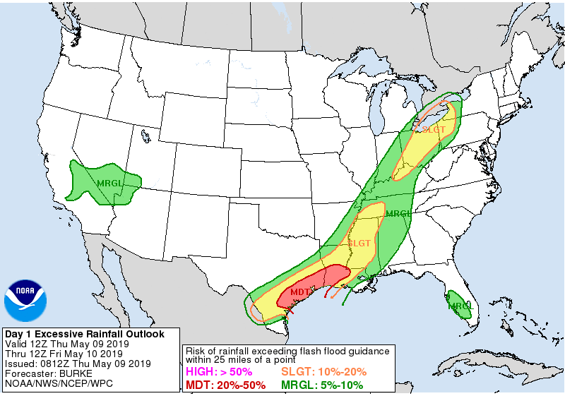
The Weather Prediction Center arm of NOAA has most of Southeast Texas in a moderate risk for excessive rainfall today. (NOAA)

We will be under a moderate risk for excessive rainfall today from the National Weather Service’s Weather Prediction Center, meaning that there’s a good chance rainfall will lead to at least some flooding. Where, when, and how much is still TBD, but these storms late today will be capable of putting down at least 1 to 3 inches per hour. As we saw Tuesday, if they are slow enough, it can be more than that.

Also, any storms today could become strong to severe, and the majority of the region is in a “slight” risk for severe weather. Strong winds and hail are the primary concerns, with brief, isolated tornadoes not out of the question either.

See full post

Storms holding off mostly Wednesday, we’re still wary though

In this morning’s post, I wrote that there was the “potential” for storms and heavy rainfall today, but we didn’t have any confidence in whether it would materialize or not. Fortunately, so far the storms have not materialized.

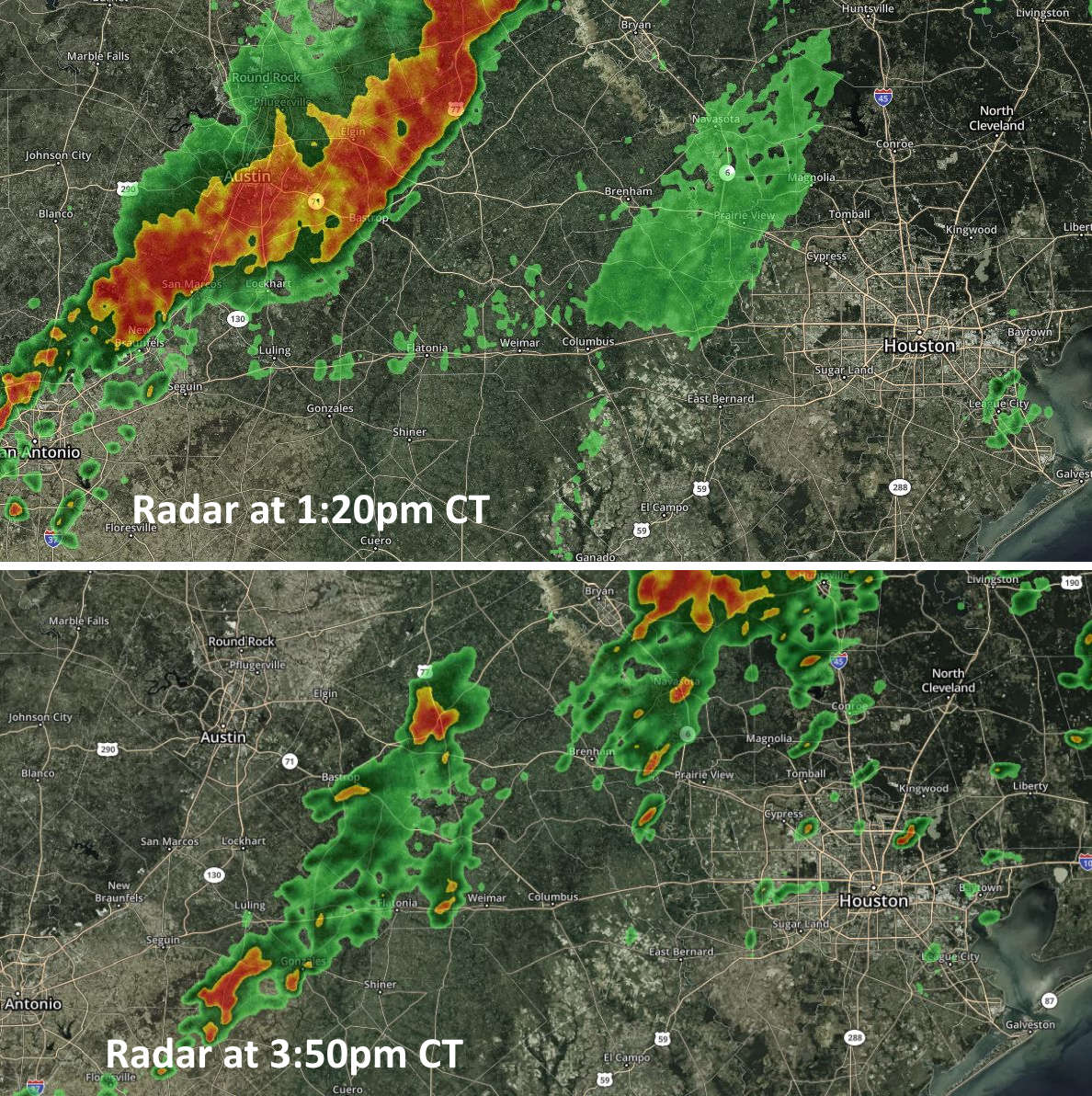
Our biggest concern today has been a broad line of showers and thunderstorms moving eastward across central Texas today, associated with a cold front. High resolution modeling suggested this line would weaken as it approached the Houston area, and in fact that is what has happened, which is good for Houston. See the comparison below of radar images from earlier this afternoon.

Radar images from earlier (top) and later (bottom) this afternoon. (kktv.com/Space City Weather)

As this broken line of showers and thunderstorms moves into the Houston area this afternoon and evening, the most likely outcome is that the system does not get too organized over the city. The best chance of storms will probably come to the north and east of Bush Intercontinental Airport, and the good news is that the storms seem to be holding a fairly steady eastward motion which should help to limit storm totals. As a result I think most of the area will probably see less than 0.5 inches of rain later today and tonight, with a few unfortunate pockets perhaps picking up a quick 1 to 3 inches.

We expect a fairly calm start to Thursday, before more showers later Thursday into Friday morning, and then yet another round from Friday night into Saturday morning. We’ll have full coverage of that tomorrow morning.

After torrential Tuesday, more heavy rain coming

By several measures, Tuesday’s rains were exceptional for parts of the Houston metro area. According to the Harris County Flood Control District, one gauge in Sugar Land recorded 5.16 inches of rainfall in 1 hour and 15 minutes, and multiple other parts of the city saw rainfall rates nearly that extreme, which will quickly overwhelm the capacity of urban roadways. Tuesday’s commute was an absolute mess. Moreover, unofficially, an estimated 400 homes flooded in Kingwood. The Brazos River at Richmond has already reached a minor flood stage. Because of the unexpected intensity of Tuesday’s precipitation, and the potential for more heavy rainfall over the next four days, we are raising the expected impacts from these storms to Stage 3 (out of five levels) on our new flood scale.

Fortunately, the storms finally died down between 9pm and midnight on Tuesday, allowing the area a reprieve during the overnight hours. This allowed several creeks and bayous near the tops of their banks to begin receding, although many remain higher than normal. So let’s discuss what happens next.

Wednesday

The unstable, very moist atmosphere that produced widespread heavy rainfall on Tuesday more or less remains in place today, and this should fuel at least some scattered showers and thunderstorms throughout the daytime in the city. We do not believe these storms will be as widespread as on Tuesday, but certainly with some of the more slow-moving systems some areas could pick up a quick 1 to 3 inches of rainfall. Overall, however, most of the city will probably receive less than 1 inch of rain today.

Severe weather outlook for Wednesday. (NOAA)

Our other concern stems from an upper-level disturbance and cold front now bringing storms to west and central Texas. This should move toward the region this afternoon and evening, bringing with it the potential for severe thunderstorms toward Houston. While most of the action will probably remain north of Houston, NOAA’s storm prediction center has brought the region where there is a “slight” chance of damaging winds, hail, and potentially tornadoes down to about the Interstate 10 corridor. This will be worth tracking.

Basically, today is a day of “potential.” The unstable atmosphere could produce a very wet day, almost like Tuesday for some areas. Or showers could be much more scattered in nature—our high resolution models have performed so poorly of late it’s just hard to say for sure. Similarly, the upper-level disturbance could remain far enough north of the metro area such that it will not cause major problems—or not. We’ll be monitoring throughout the day for you.

See full post

Heavy rains, multiple flood warnings … and it’s just Tuesday

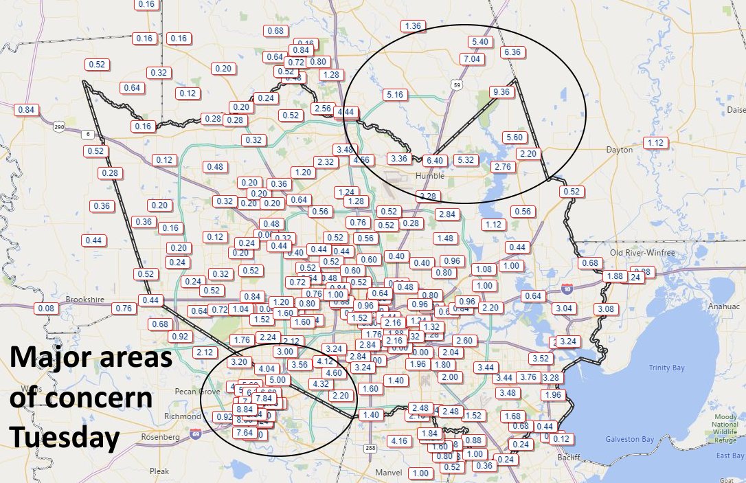
Earlier, we posted that we expected the heavy rainfall to wane between 6pm and 9pm this evening. Unfortunately, the storms have sustained themselves as the sun has gone down and continued to pile on rain totals—especially to the southwest of Houston in areas such as Sugar Land and Richmond. Regions there have now recorded 8 to 10 inches, nearing the exceptional amounts recorded in Humble and Kingwood earlier today and this afternoon.

Tuesday rain totals were very impressive NE and SW of Houston. (HCOEM)

So what happens now? With the sun now falling below the horizon, the rain cooled atmosphere will have less energy to sustain itself, and from a pure physics point of view, these heavy rain showers really should really ebb over the next 3 to 6 hours. But it is hard to have overly much confidence in this forecast given how much we’ve missed already today. We’re hoping for a break later tonight and perhaps Wednesday morning.

Where does this leave us? Quite frankly, we didn’t anticipate that the rains would be as intense as they were today. Certainly, we didn’t expect 10 inches of rain for any part of metro Houston, nor the need for high water rescues as are presently ongoing in southwest Houston. Yet here we are on the first day of a multi-day event, with soils now thoroughly sodden; some bayous near bank full; river concerns; and more.

Forced to guess, I’d say we’ve got two more major rounds of storms to worry about after this evening. There likely will be widespread showers on Wednesday night and Thursday, and then some kind of mess on Friday and Saturday. If those rounds are as bad as we’ve had today, then we’re going to see a much worse situation than now, but I don’t think we can quite say that yet.

We’ll be back with a full report in the morning.