Hot weekend, but yes, we’re eyeing a rare June cold front next week

Last night saw some wild storms in parts of the area, especially southeast, south, and west of Houston. The storms did cause some damage, primarily west of Houston.

You can click here for a rundown of storm reports. The real show for many of us came after the storms, with a true spectacle of light, color, and clouds.

Today

My feeling is that the bulk of today will be calmer than what we have seen in the back half of this week. Yes, showers and thunderstorms may develop this afternoon once again. We would favor the highest rain chances today south and east of Houston, along the sea breeze as it moves in from the Gulf. So if you’ll be on the beach today, just be aware. Otherwise, it should be partly to mostly sunny today with a good deal of heat and humidity. Look for us to get into the low-90s on average with a few mid-90s possible.

Weekend

This weekend is going to feature legitimate summer heat. Expect both days to have plenty of sunshine. We should hit the mid-90s on Saturday and the upper-90s on Sunday. The humidity will make it feel like 100-105° at times tomorrow and probably just shy of 110° on Sunday.
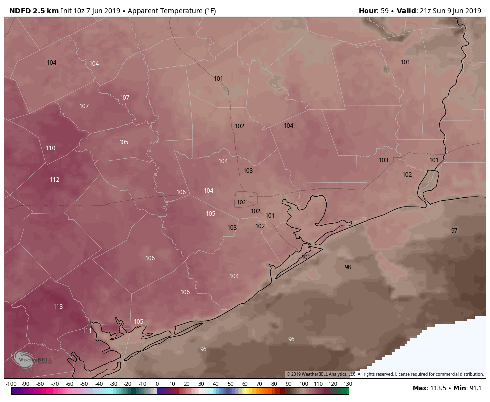
Heat index values will push or exceed 105° at times this weekend. This map is for 4 PM Sunday. (NWS via Weather Bell)

This would be especially true near the bays and coast after the sea breeze moves through, raising humidity levels. Regardless, you’ll want to take it easy this weekend if outdoors. Drink plenty of water, and try to be in air conditioning if possible during the peak heating of the late afternoon and early evening. Our nighttimes will also be warm & muggy, with low temperatures generally in the mid- to upper-70s and around 80° near the coast.

See full post

Heavy storms approaching Houston this evening

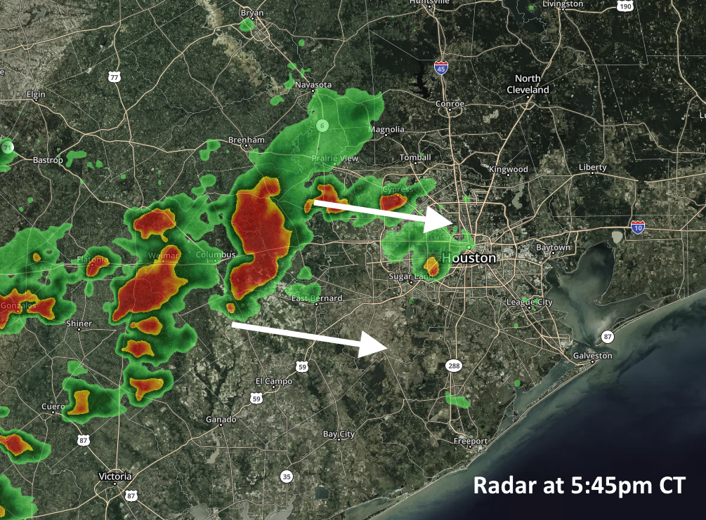
The National Weather Service has issued several watches and warnings for this afternoon and early evening as a fairly intense line of showers and thunderstorms is moving toward the Houston metro area from the west. These storms are capable of producing damaging wind gusts up to 60mph, and quarter-size hail.

Radar at 5:45pm CT Thursday. (kktv.com)

The severe weather has the potential to impact the entire metro area through around 8pm, but may linger across areas south of Interstate 10 until around midnight. The good news is they are moving rapidly from west to east, so individual storms should hopefully transition through the area quickly enough to avoid significant flooding problems.

Even so, it won’t be fun to be caught out in the storms, so please be weather-aware throughout this evening.

Storms possible again this evening, weekend still looks hot and sunny

Good morning. We have a couple of more days with the potential for storms across Houston, but we’re not expecting anything like the widespread, long-duration showers and thunderstorms we experienced on Wednesday. This weekend still looks quite hot and sunny, especially Sunday.

Thursday

A line of storms has fired up early this morning, but it is weakening as it moves toward the Houston metro area. Unfortunately, however, these thunderstorms could bring another quick 0.5-1 inch of rain to hard hit parts of southern Fort Bend, Matagorda, and Wharton counties. After these morning showers, the region should see a break until later this afternoon or early evening. By this point another line of storms moving out of central Texas should approach the Houston area.

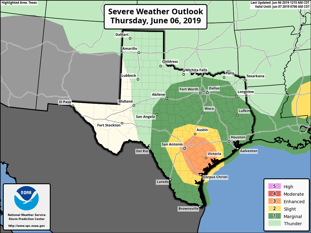
NOAA severe storm outlook for Thuesday.

These storms may (hopefully) weaken again as they approach Houston, and NOAA’s Storm Prediction Center has highlighted an area well to the southwest of Houston as seeing an “enhanced” chance of storms. Even so, in Houston we’ll need to be on the lookout for potentially severe thunderstorms late this afternoon and into the evening hours—right around the evening commute. The biggest threat will be damaging winds and possibly some hail. Since the storms will move through fairly quickly, we don’t anticipate any significant flooding, despite our sodden soils. Highs today will be in the low 90s.

See full post

Main threat of heavy rainfall over, but we have some Thursday concerns

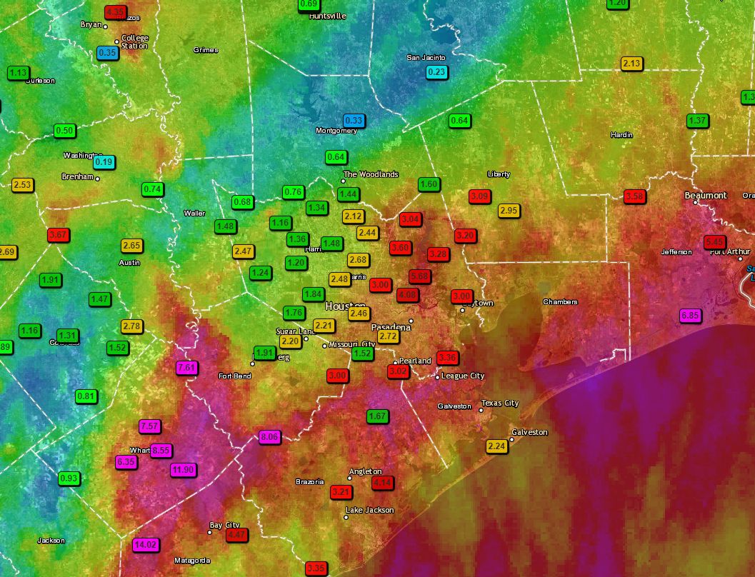
It’s been long day of storms for parts of the metro area—fortunately for Houston pretty much everything has now moved east toward Beaumont and Port Arthur, or (better) southeast into the Gulf of Mexico. Houston should (mostly) have a quiet night as storms fire to the east. Before getting to the forecast for the next few days, I wanted to share the following map of rainfall totals during the last 24 hours. It neatly illustrates the challenges of forecasting tropical precipitation along the upper Texas coast.

24-hour rainfall totals through 5pm CT Wednesday. (Texas Mesonet)

A few notes: We actually pinpointed the Matagorda region as a potential hotspot during the overnight hours, and they along with Wharton County certainly bore the brunt of heavy rainfall with 14+ inches in a few locations. An area near College Station also picked up 5 inches of rain, as did Port Arthur. Closer to Houston, the eastern half of Harris County got the worst of it on Wednesday. I would also like to point out that fewer than 100 miles separates Wharton, where a foot of rain fell, from Conroe, where one-third of an inch fell. Welcome to meteorology.

See full post