Houston soars past 100°, Galveston sets all-time heat record

For the first time in 380 days, Houston officially hit 101° on Thursday afternoon. Since 1980, we have averaged about 3 to 4 days this hot per year. Another interesting nugget about Thursday: With a high temperature of 101°, a low temperature of 81°, and a daily average temperature of 91°, it was Houston’s hottest day since August of 2016.

By far the most impressive statistic came from Galveston on Thursday. The temperature never dropped below 86°, meaning Thursday saw the warmest minimum temperature ever recorded in Galveston, with records dating back to 1874.

In addition to a daily record high yesterday, Galveston’s low temperature was the warmest it has been on record (since 1874) on the island. (NWS Houston)

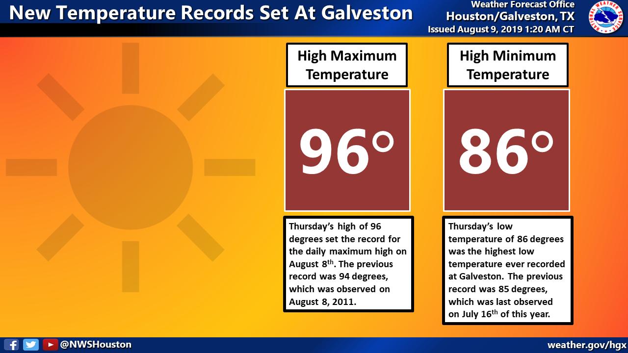
Since 2015, Galveston has set or tied 90 warm daily minimum temperature records, or near 25 percent of all of them. In just five years! This is consistent with what has happened elsewhere along the immediate Gulf Coast. New Orleans has set or tied warm minimum temperatures 120 times since 2015, while Tampa has done it over 130 times. Corpus Christi has has new warm minimum records over 50 times since 2015. This likely speaks to a combination of a fairly warm Gulf of Mexico in recent years and is also a symptom consistent with what is expected due to climate change. Galveston will likely match or exceed several more daily warm minimum temperature records before summer is over.

Today through Sunday

It’s going to be oppressively hot and humid again today. High temperatures will hit the mid-90s at the coast and upper-90s or 100° inland. Heat index values will again likely be at least 105° to 110°, with several locations likely to push even higher.

Anywhere you see the darkest red color on this map, heat index values are expected to exceed 110° this afternoon. (NWS Houston)

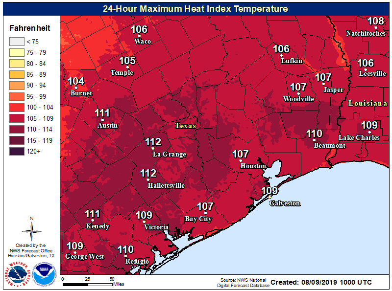
Galveston maxed out with a heat index value of 117° on Thursday afternoon. We may not be quite that absurd today, but it will come close.

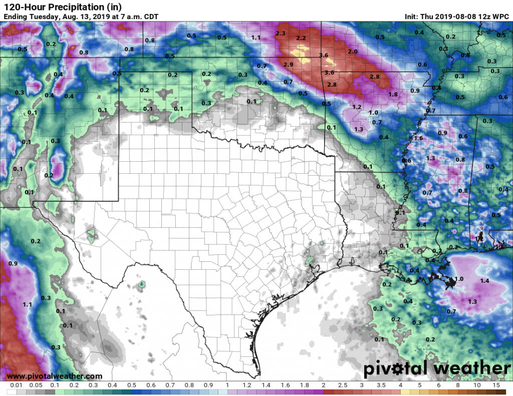
Saturday and Sunday sees high pressure anchor itself over the state of Texas. This will keep the heat rolling on with more of the same: At least mid- to upper-90s for highs, with 100° or higher possible. Nighttimes won’t see temperatures drop below the upper-70s or low-80s. Humidity and heat index values may drop off just a bit on both weekend days as that drier high pressure sits overhead. If you’re looking for rain, you won’t find it here.

See full post

Houston may reach 100 degrees for the first time this year

On Wednesday, officially, Houston came awfully close to 100 degrees. The temperature at Bush Intercontinental Airport spiked up to 99 degrees during the afternoon. Previously this summer, the high temperature had topped out at 97 degrees on several days. With high pressure now firmly in control of our weather, we can probably expect to hit the century mark today, or almost certainly in the coming days.

Thursday

A heat advisory is in place for today, with high temperatures likely in the upper 90s to 100 degrees, and the heat index—which factors in humidity—potentially reaching 110 degrees. Please take extra caution with mostly sunny skies, and very light southerly winds. We can’t entirely rule out a few stray showers and thunderstorms along the sea breeze, but precipitation is unlikely.

Friday, Saturday, and Sunday

The weekend will see more of the same, with highs likely to reach 100 degrees for inland areas, sunny skies, and warm nights with lows only falling to around 80 degrees. This is mid-August for you.

DRY TEXAS: Rain accumulation forecast for now through Monday. (Pivotal Weather)

Next week

The heat will likely continue for the first couple of days next week before the high pressure dominating the region’s weather pulls back to the west. This may allow for a more northeasterly flow, some slightly less hot air, and perhaps some slight to moderate rain chances.

Energy saving tips from Reliant

As temperatures push up toward the century mark, we all will be tempted to crank up our air conditioners. Reliant is here to help and remind readers about the benefits of saving energy, for both your electric bill and the state’s power grid.

  • Check out these energy efficiency tips and tools that could help you save energy and lower your electricity bill. Most of these tips are simple enough for anyone to do, like increasing the temperature on your thermostat a few degrees and avoiding heat-generating activities like using the oven or dryer in the afternoon hours.
  • If you’re a Reliant customer, you can track your electricity usage alongside daily temperatures with the Reliant app for iPhone or Android (you can also find Space City Weather linked there). Plus, you can set personalized alerts for electricity usage, bill estimates and more.
  • Reliant also has a cool program that rewards customers for making small changes to conserve energy during periods of high electricity demand. Customers can earn bill credits through the Degrees of Difference program when they cut down on energy usage during reduction requests, which helps reduce the load on the Texas electricity grid. Click here to learn more and sign up.
  • Remember you have a few more days to enter to win a new AC from Reliant by clicking here or share the link with someone in need. The deadline is August 13.

“It’s not the heat, it’s the humidity?” In Houston, we’re getting both

Rain showers over the last week have been completely hit or miss, with some areas such as Pearland or Baytown receiving 1.5 to 3 inches of rainfall, and many other areas including The Woodlands and West University Place getting none. As a result, some readers may think the last seven days have been quite wet, while others have watched the storm clouds form, only to hear distant thunder but see no measurable rain. What I’m confident of now is that virtually no one will see rain for the next week as high pressure settles in.

Seven-day rainfall totals through Wednesday a.m. (HCOEM)

Wednesday

Today will still see a slight chance—maybe 10 percent?—of isolated showers along the sea breeze before high pressure truly clamps down on our weather. Highs likely will be otherwise in the mid- to upper-90s with mostly sunny skies and light southerly winds at 5 to 10 mph.

Thursday through Tuesday

There simply isn’t much to say about Texas weather in the summer, beneath high pressure. We will see highs in the upper-90s to 100 degrees. Skies will be sunny. Overnight lows will be in the upper 70s to low 80s. They say it’s not the heat, it’s the humidity? Well, my friends, in Houston we’re blessed with both.

Later next week

Forecast models indicate the pattern will finally break by the middle or end of next week, as high pressure weakens and perhaps a more northeasterly flow sets up across the region. This should bring high temperatures back down a bit, and nudge rain chances up somewhat. After a week in the fryer, we’ll be ready for any modicum of relief.

Atmosphere may squeeze out a few showers today, but …

A broad dome of high pressure will still build across the Houston region later this week, but we should have another chance of showers today before the heat really sets in. This weekend, in particular, looks hot.

Tuesday

High-resolution models are showing 20 to 30 percent rain chances today, especially later this afternoon along the sea breeze. These showers will definitely be hit or miss, with most of us likely on the “miss” side. The HRRR model forecast below shows what the radar might look like at around 4 or 5pm this afternoon. High temperaturess will push into the mid- or upper-90s with partly sunny skies.

HRRR model radar forecast for 5pm CT on Tuesday. (Weather Bell)

Wednesday

Still have a very slight chance of rain, perhaps 10 percent, as high pressure builds over the region. Highs will be in the mid- to upper 90s with light southerly winds.

Thursday through Monday

Honestly, there’s not much to say about the weather forecast, so why waste words? It’s going to be awfully hot. Temperatures will reach the upper 90s to 100 degrees for Houston, with mostly sunny skies and light winds. Overnight lows will be sultry, only dropping to 80, or briefly into the upper 70s, for inland parts of Houston. As ever, August is a rough month for the region.

Next week

When will the high pressure break? The long-term ensemble models suggest this may happen toward the middle or end of next week, but that’s pretty much at the edge of predictability, so who knows.