Finally, some relief from a dead hot pattern over Houston

Not every part of Houston received rain on Wednesday evening—some parts of Katy, Kingwood, and Galveston saw a lot of lightning, but precious little precipitation. But for much of the metro area, the rain did come come, in sheets, falling onto dry ground and streets so hot after seven days of 100-degree heat that they steamed afterward. For me, it brought to mind a classic Steve Earle song, The Rain Came Down, about a farmer desperate for rain, with lyrics such as, And the rain came down, Like an angel come down from above. It did feel pretty amazing.

On Thursday morning, Texas is quite a bit cooler than it’s been. (Weather Bell)

Thursday

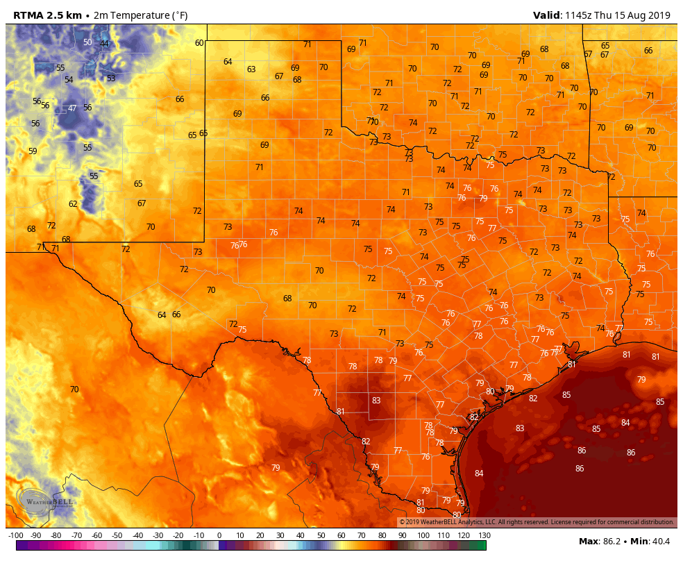
For all but the immediate coast, temperatures have fallen this morning into the mid- to upper-70s, which is cooler than most of the last week. With partly sunny skies, we’re still going to see a warm day today, with highs likely reaching into the upper 90s. (It is mid-August, after all). The focus for showers and thunderstorms today will likely occur closer to the coast. High-resolution models indicate the potential for active weather to the southwest of Houston, in Fort Bend and Wharton counties, as well as to the east in the Beaumont area. But with that said, I think rain chances in the Houston metro area itself are probably about 40 percent this afternoon and evening.

Friday

This should be a bit drier of a day, with perhaps only 30 percent rain chances and mostly sunny skies. It will remain quite hot, with highs in the upper 90s, and a few inland areas possibly seeing 100 degrees.

See full post

Today remains hot for Houston, but change is beginning

Good morning. Just a quick note before today’s post—I wanted to say thank you to the 250 or so people who came out to the Houston Museum of Natural Science on Tuesday evening to hear Matt and I talk about the site, weather, hurricanes, and more. It was wonderful to meet so many of you, especially the two lovely young women who read this site to their mom every morning for practice—I’ve forgotten your names, and I’m truly sorry—but I promise to keep everything PG!

Wednesday

Change is coming slowly to Houston, but we’re still going to see another very hot day. The city has now recorded six consecutive days of 101-degree temperatures, and I don’t quite think we’ll get there today. But a heat advisory remains in effect, and we’ll at least get into the upper-90s if not 100 degrees.

Texas highs should generally be 2 to 5 degrees cooler than they were Tuesday. (Pivotal Weather)

Nevertheless, change is on the way, with high pressure finally beginning to back off to the west. This should allow for a fairly healthy—40 or 50 percent?—chance of showers late this afternoon and evening as the sea breeze migrates inland and collides with a disturbed atmosphere moving south. For the most part accumulations will be measured in the tenths of an inch, but a few heavy thunderstorms may drop more. Lows tonight will still be in the 80s.

See full post

Last day of brutal heat before some moderate relief arrives

Houston endured its sixth consecutive day of a 101-degree high temperature on Monday, and the region may well have one more today before some relief finally arrives in the form of a weak front. There won’t be much cooler air, but clouds and rain chances will help moderate temperatures as high pressure eases off to the west.

Tuesday

But not today. Once again, Houston will bake beneath triple-digit heat on Tuesday and mostly sunny skies. Very light southeast winds will offer almost no relief, and Tuesday night’s lows will again be around 80 degrees for much of the region. Needless to say, a heat advisory remains in effect. The only good news from a weather perspective? August is almost half over.

Tuesday’s highs are, in a word, ugh. (Pivotal Weather)

Wednesday

As high pressure backs off to the west, a weak front will move southward into the state. Depending on the timing, this will either limit highs to the upper 90s, or mid 90s—still very hot, but not as hot as we’ve been. Clouds will increase some, and rain chances will bump up to about 40 percent during the day and overnight hours. We aren’t expecting anything spectacular in terms of accumulations, but anything will be welcome after an extremely hot and dry week.

See full post

Record-breaking warmth continues, but the heat wave’s end is in view

The region’s streak of very hot days and record-setting nights continues as high pressure dominates Houston’s weather. Here are a few notable trends from the last week across the region.

  • Bush Intercontinental Airport recorded four consecutive days of 101-degree high temperatures through Sunday.
  • Galveston has had six consecutive days in which overnight lows have only fallen to 84 degrees, the second longest streak after the heat wave of 2011.
  • Houston’s Hobby Airport set or tied its record low temperature on August 7, 8, and 9 with lows of 80 or warmer.

All of these trends are likely to continue Monday and Tuesday as the ridge of high pressure continues to dominate our weather. Fortunately, the pattern should begin to change by the middle of the week.

Texas will bake again on Monday. (Pivotal Weather)

Monday

A few, isolated areas of Houston saw some brief showers and thunderstorms on Sunday afternoon, as rising moisture was able to combat subsidence in the atmosphere. We may see a similar pattern today, with 10 to 20 percent of the region seeing brief showers. Any relief from the heat will be temporary, however, as we still expect a hot way with much of the area seeing 100 degrees. Nighttime lows will again be around 80 degrees for most of the area.

See full post