Good morning. Winter Fest 2021 has arrived in Houston, complete with frigid temperatures, snow, sleet, freezing rain, howling winds, and power outages. It is everything we expected and dreaded.
An extremely cold air mass has descended upon the area and dropped temperatures to 20 degrees or below for nearly everywhere, including the coast. With the wind chill, it feels like 0 degrees for inland areas and 5 to 10 degrees elsewhere. Wintry precipitation overnight, a combination of primarily snow and sleet, has covered most area roadways with a sheen of ice. Travel today is a bad idea.
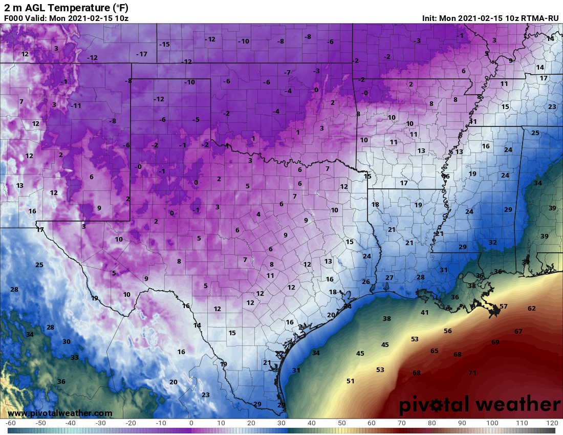
Temperatures across Texas at 4am CT on Monday. (Pivotal Weather)
Monday
High resolution models show precipitation ending from west to east this morning, and likely moving east of the Houston metro area by around 9am. This will not preclude the possibility of some snow flurries redeveloping later this afternoon. Unfortunately, temperatures are unlikely to recover much today, with highs perhaps in the low to mid-20s across the region. The ice on roadways is not going anywhere, any time soon.
We still expect an extremely cold night across Houston, with temperatures likely ranging from about 5 degrees over inland areas to around 20 degrees along the immediate coast. These will be the region’s coldest temperatures since at least 1989, and for some areas possibly much longer than that.
Tuesday
After a bitterly cold start to the day, sunshine will help lead to modest warming as winds shift to come from the east. By Tuesday evening, we anticipate that temperatures will climb above freezing for areas south of Interstate 10. Temperatures on Tuesday night really will not fall much as the onshore flow kicks in.
Wednesday
Sunshine will go away by Wednesday, as moisture levels rise in the atmosphere and the next front approaches. Most of the metro area should reach highs in the upper 30s to low 40s on Wednesday (the coast will be warmer still), although areas north of Conroe may remain stubbornly near freezing. As precipitation chances increase on Wednesday, it appears that most of the area will see rain, but we have concerns about freezing rain in Montgomery County, and points north, both on Wednesday morning and any lingering showers Wednesday night.
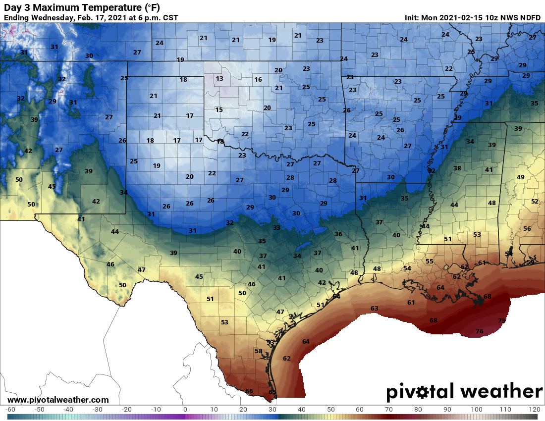
High temperatures on Wednesday should bring a (brief) end to the freeze for most areas. (Pivotal Weather)
Thursday
Another very cold day, with most of the region likely only reaching a few degrees above freezing. However, we think this probably will be warm enough to melt any ice on the roads by mid-morning or so in the metro area, with some caveats about the potential for lingering ice near and north of Conroe. Much of the area will see a hard freeze on Thursday night, with lows dropping into the 20s.
Friday, Saturday, and Sunday
As high pressure settles in we’ll finally a see a definitive warming trend heading into the weekend, with highs in the 40s on Friday, and reaching the 60s for most areas by Saturday.
Power outages
There are two sets of power outages this morning. One is due to ice accreting on power lines, and this is affecting about 5 percent of homes in the Houston area. In addition to this, there have been rolling blackouts ordered ERCOT across the entire state that should last about 15 to 45 minutes at any one location.
Good afternoon everyone. I’ve been watching the models and observations all day, and we look to continue walking a fine line between ice, an even mix of ice, sleet, and snow, and a bigger snowstorm in the Houston area. Not a whole lot has changed from Eric’s detailed morning post, but let’s freshen up the forecast a bit based on what we’re seeing right now.
Now
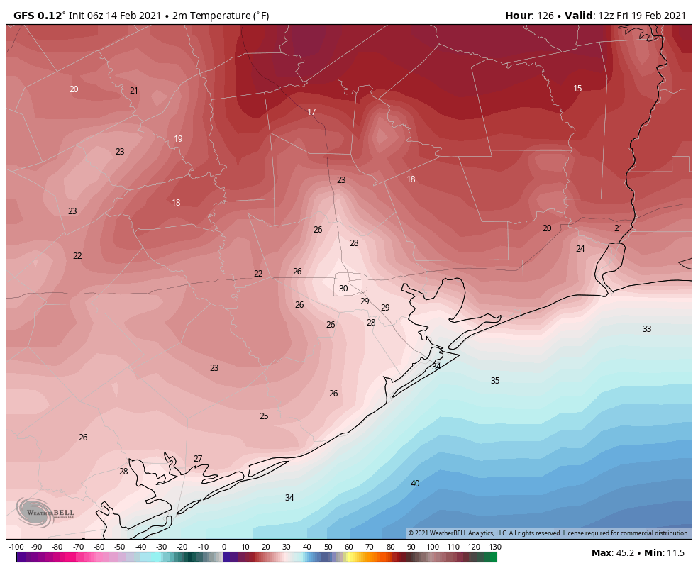
As of 4PM, here is a map of where temperatures are currently below freezing (locations above freezing not shown).
Below freezing temperatures are creeping south and east into the Houston area. Icing will commence soon on many area roadways. (NOAA)
So, if we roughly overlay that freezing line on radar, you can see where the risk of ice is at the moment I am writing this.
Areas north of I-10 and west of US-59 are at risk for icing as of 4 PM Sunday. This will worsen over the next few hours. (RadarScope)
Basically anywhere along and west of US-59 and north of I-10 is at risk for icing on roadways as of now and worsening over the next 2-3 hours.
Through Midnight
Over the next few hours, watch for rain, freezing rain, and freezing drizzle to overspread most of the region. Temps will continue to glacially drop off slowly, eventually putting everywhere but probably the immediate coast below 32° by midnight. Ice accumulation should not be significant in terms of weighing down trees and power lines this evening, but you’ll begin to notice a glaze on most outdoor surfaces, and travel will become hazardous to impossible across the entire region.
Midnight to 7 AM Monday
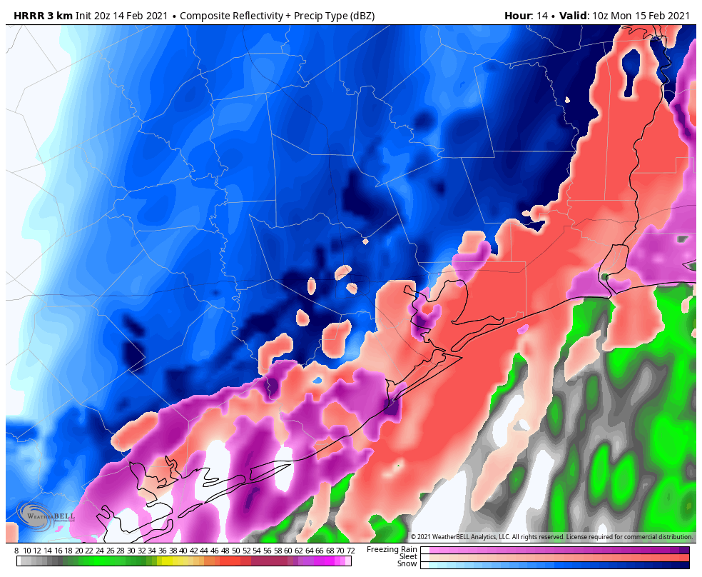
Two things will happen after midnight: Colder air will speed up its arrival in the area and the precipitation should become more organized and heavier. Our forecast confidence begins to drop off here, but theoretically, this should mean that freezing rain will transition more to sleet and eventually snow. That transition will take place from northwest to southeast and where the precipitation falls heaviest.
The HRRR model forecast of precipitation at 4 AM shows freezing rain and sleet transitioning to sleet and snow across the region. This is just one of several possibilities for how tonight may unfold. (Weather Bell)
This is when we will probably start seeing and hearing reports of heavy sleet and even heavy snow in parts of the area. I’ll be honest, as a Northeast native, what is being depicted on some of the models is the potential for bonafide, real deal heavy snow and/or sleet, particularly north and west of Houston (think far NW Harris County, Montgomery County, College Station, Huntsville), but perhaps in the city or even some places east of the city too. We’re talking potential of 1-2″ per hour snow rates if we flip over. If the warm layer a couple thousand feet up holds, then heavy sleet will the story, and we’ll see 1 to 2 inches total of “cement” on roads and surfaces.
Quick note and reminder: If we end up with sleet or sleet/snow accumulation and you have to shovel or clear surfaces, please take it slow and take it easy. There is a known link between shoveling snow/sleet and heart attack risks, to the point where hospitals up north often staff up for that very reason ahead of storms.
7 AM to Noon Monday
Precipitation should begin to wind down from west to east before Noon on Monday. Most places will end as a period of snow or flurries.
When all is said and done, expect 1-3″ of snow, more northwest, less southeast. Expect a tenth to a quarter inch of ice, more southeast, less northwest. Higher amounts are possible in either case.
Monday afternoon
Despite the precip ending, conditions won’t improve much. It’ll remain quite cold and any chance of sunshine will probably hold off til late day or Tuesday. Eric will update you on that chance in the morning. Either way, we won’t be getting above freezing on Monday, so whatever falls is going to stay in place through the day and into Monday night.
Monday night/Tuesday morning.
No big changes to the forecast for Monday night and Tuesday morning. It will be cold, likely damaging cold. Please make sure you’ve finalized all preps for pipes and plants by now, and look out for pets and neighbors.
Tuesday morning low temperatures are mostly unchanged from prior forecasts and still likely to challenge records and perhaps some all-time records as well. (NOAA via Weather Bell)
There’s still a tad bit of uncertainty on exactly how cold we get, contingent on how many clouds remain, how much snow falls vs. sleet/ice, and how windy it is. But either way, a damaging, destructive, probably historic freeze is on the way Tuesday morning.
Tuesday afternoon and beyond
Look for slowly rising temperatures Tuesday, probably close to freezing from I-10 south and just shy of it north of there. We should have sunshine, and that will allow for some melting to occur, but there’s a chance most roads remain sloppy to impassable most of Tuesday too.
And then beyond Tuesday, I don’t want to speculate too much still, but it does look like Wednesday’s storm will be a mess for northern fringes of the area. The potential exists for a serious ice storm north of Houston (probably plain rain in most of the Houston metro itself). Coastal locations may even make a run at 50+ degrees on Wednesday. Between storm track issues and potential snowpack issues (keeping temperatures cold), there is a lot we don’t know about Wednesday. Look for an update by about 5:30 in the morning from Eric.
Good morning. Today is the last day most of the Houston area will see above-freezing temperatures until Wednesday. We have a section at the end of this morning’s post about preparations for the upcoming hard freeze, this really is your last opportunity to do so. After today, Houston’s weather is going to be full on winter until at least Friday.
We’re going to discuss this in three phases: Winter storm on Sunday night into Monday, Extreme cold on Tuesday morning, and a Second Arctic front on Wednesday through Friday morning.
Sunday and Monday
Today will be far from pleasant, but for most of Harris and surrounding counties, temperatures through at least the early afternoon should remain above just above freezing. Additionally, any precipitation that falls before around 4 to 6pm this evening should do so as rainfall. (Note: you don’t have to get too far west of Katy, or too far north of Conroe, before you run into freezing rain today). By late afternoon or early evening, temperatures should begin to drop below freezing across the area, from west to east as an Arctic front moves into Houston.
This front will have two immediate effects. From sunset on Sunday to sunrise on Monday, temperatures will plunge into the low 20s across the metro area. And it will bring a healthy dose of precipitation to the region. If this were to fall as rain, it would be about half an inch for most locations, but due to the cold temperatures, we’re going to see some form of winter precipitation. But what kind? We talked yesterday about how, for snow to reach the ground, temperatures must remain freezing from the surface all the way to clouds where precipitation forms.
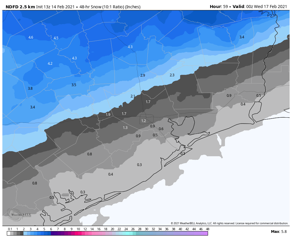
Current National Weather Service snowfall forecast for Sunday night. Subject to change! (Weather Bell)
On Sunday evening, the atmosphere is unlikely to be below freezing all the way up, so I think most areas will see a glaze of freezing rain fall before it turns to snow. We’re now reasonably confident that areas north of Interstate 10 will see on the order of 1 to 4 inches of snowfall by around mid-morning on Monday. We’re less certain what will happen closer to the coast, where there may be enough lingering “warm” air from the Gulf of Mexico to produce sleet or more freezing rain rather than snow.
The forecast models now suggest this precipitation will end by mid-morning, as the atmosphere dries out. We still can’t have complete confidence in what area roadways will look like, but the potential for a glaze of ice on the surface, covered over by snowfall, is a rather dangerous one. You should be prepared to not go anywhere from Sunday evening through Tuesday morning. Some major roadways may be cleared by authorities, but this kind of winter storm is unprecedented in recent decades because temperatures on Monday will not get high enough to melt roads. Rather, daytime temperatures will remain in the low to mid-20s. So anything that falls, will stick.
Monday night and Tuesday
We still have lots of questions about the severity of cold weather on Tuesday morning, but if the snowfall forecast verifies for Houston it will amplify the cold weather. The combination of snow cover, light winds, clearing skies and an Arctic air mass is pretty much about the most ideal conditions you could conceive for cold temperatures in Houston. However if the region gets more sleet or freezing rain, and clouds linger, temperatures could be somewhat warmer.
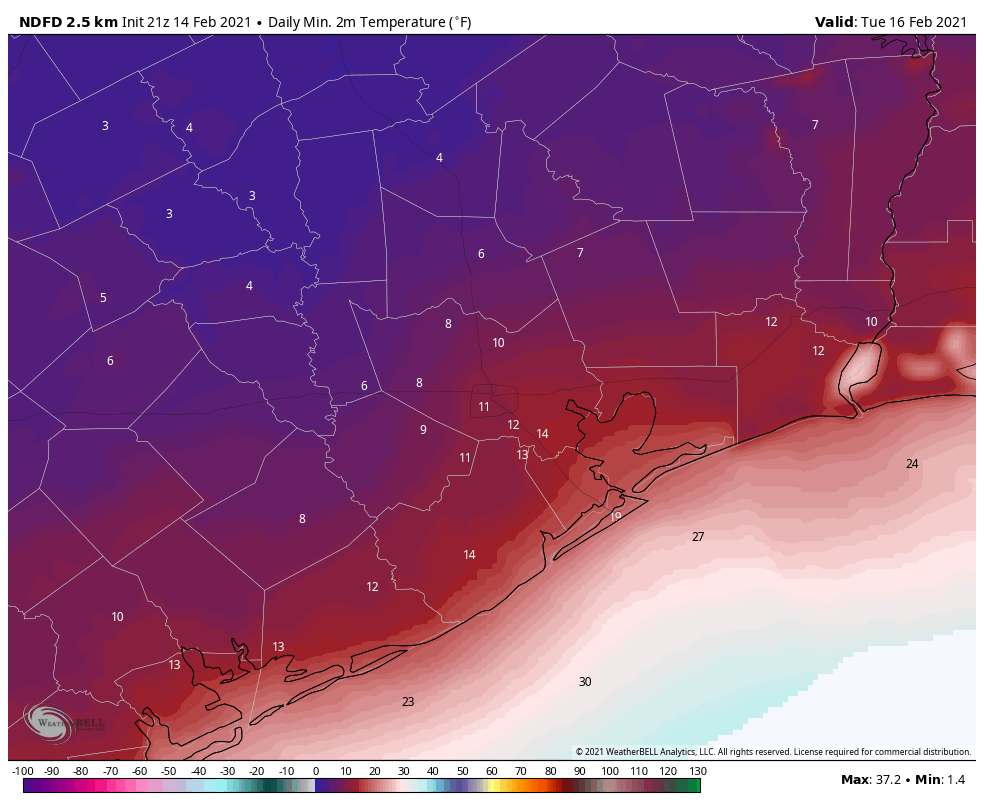
As a result, I think we’re looking at a range low temperatures from 5 to 15 degrees for western Harris County and Montgomery County, 10 to 20 degrees in central Houston, and 15 to 25 degrees along the coast. As Matt discussed yesterday, this would be a historic cold snap for the region.
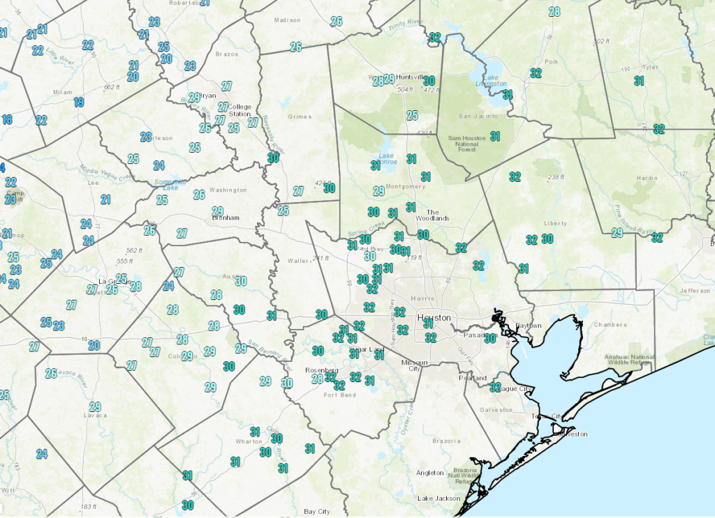
Sunrise temperatures on Tuesday morning. (Weather Bell)
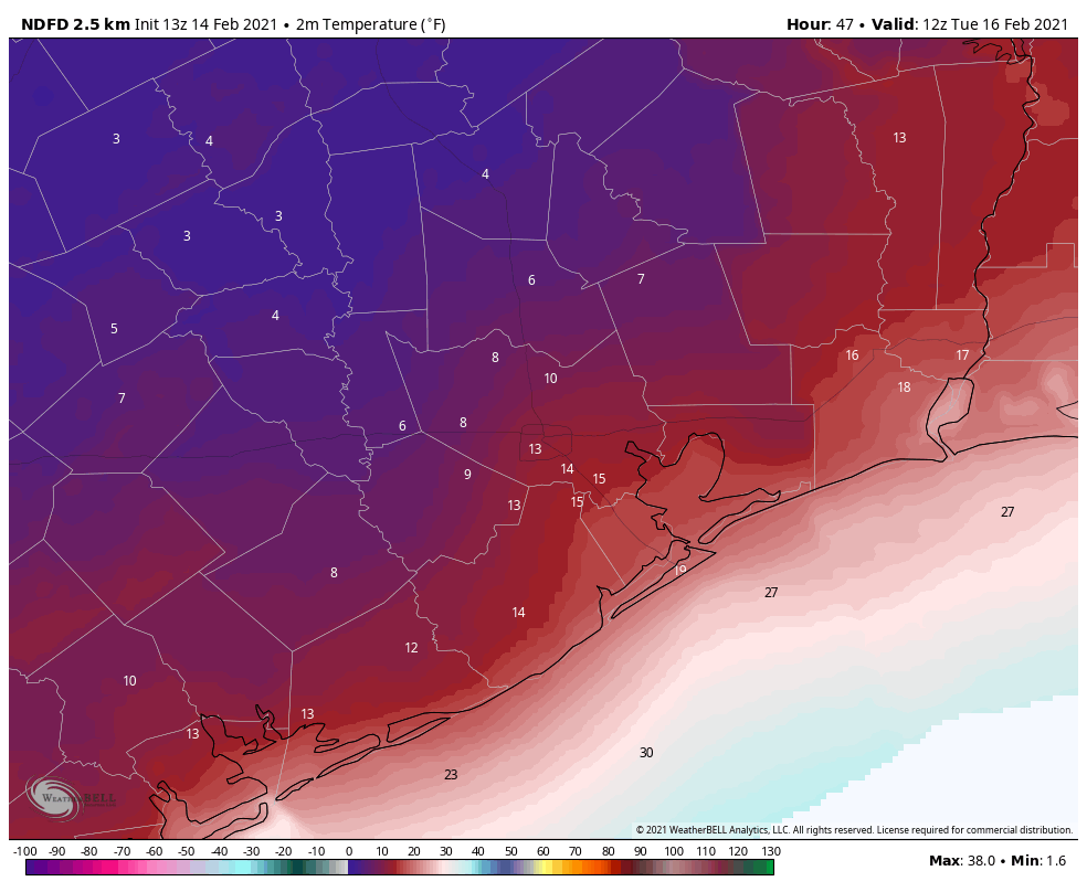
Another question we have is where temperatures may briefly rise above freezing on Tuesday. The coast is a definite yes, where highs may reach the upper 30s. Many areas south of Interstate 10 may briefly see highs of 33 degrees or slightly warmer. I do not know whether this, in combination with mostly sunny skies, will be enough to melt and dry roads. Much of the region north of Interstate 10 will remain below freezing during the daytime. Temperatures Tuesday night will only drop a little bit below freezing.
Wednesday and beyond
Part three of our collision with winter will come later in the week. Yet another storm system will approach from the west early on Wednesday, and it will draw Gulf moisture into the region. Much of the Houston metro area is likely to see another 0.5 to 1.0 inch of precipitation on Wednesday. This may start out as freezing rain early in the morning, but as daytime temperatures climb to about 40 degrees, it should turn to rain. This should also melt any lingering ice on roads.
However, temperatures on Wednesday night will probably drop below freezing for everywhere but the coast, so this sets up a situation where roads are problematic again on Wednesday night and Thursday morning due to ice. We’ll have to nail down these details in the coming days. Highs Thursday should rise above freezing and will hopefully melt any ice on the roads, but we’re going to remain close to freezing. Again, details to come on this.
Friday morning should produce the last freeze of the week (and perhaps of this winter?) (Weather Bell)
Highs Friday should finally push at least into the mid-40s, with sunny skies. That will be the end of the winter storm. By Saturday, we should be into the 60s.
Final preparation tips
These suggestions were provided by Jeff Lindner, a meteorologist with the Harris County Flood Control District.
PIPES: Protect all and any exposed pipes, shut off and drain sprinkler systems. Open cabinet doors and closet doors to get as much heat against outside facing wall pipes as possible starting Sunday night. In some cases the best course of action may be to shut off water to a structure and drain pipes overnight when water usage is low to avoid pipes freezing and bursting.
PLANTS: Heavily cover and protect any tropical vegetation, citrus, or vulnerable plants. Given the intensity and depth of the freezing conditions this will likely be a killing freeze for much of the tropical landscape of this region.
PETS: Pets and livestock should have proper shelter, feed, and water. Normal water supplies will likely freeze over including stock ponds and lakes.
PEOPLE: Persons should plan to limit outdoor exposure Monday and Tuesday as wind chills will be dangerously cold for our region. Prolonged exposure could result in frostbite and hypothermia. Please ensure your neighbors have adequate heating.
Matt will have our next update on the site by around 4 or 5 pm CT today.
With the deep freeze on the way to Houston, Eric thought it would be a good idea to take a look at some previous significant cold in Houston, so we can place this outbreak in historical context. As Space City Weather’s unofficial history guru, I’ve taken on the challenge!
Quick forecast update
Eric’s morning post does a nice job discussing what we know and expect over the coming days. Not a whole lot has changed, though I think three things stand out.
1.) First, there is a real chance that there could be some freezing drizzle or light freezing rain overnight tonight and Sunday morning. Please check with us or other local outlets if you are planning to travel anywhere tomorrow morning.
2.) Second, the start time of Sunday evening’s precipitation has sped up a bit, and we may see rain or freezing rain or sleet begin as early as 3 or 4 PM on Sunday.
3.) It seems colder air may push in here a little faster on Sunday night and Monday morning. This is both good and bad. It’s bad in the sense that we’re likely to endure a longer stretch of temperatures in the mid-20s or colder. It’s good, however, in the sense that this might lead to more sleet (or snow) and less freezing rain. Forecasting precipitation types is extremely challenging, as Eric noted this morning, so I expect more curve balls to be thrown our way between now and tomorrow evening, but at least this afternoon, it looks like sleet may be the more common precipitation type we see tomorrow night. We’ll have more for you in the morning.
February 2021
So, to begin our trip through history, let’s set the table with the current cold outbreak.
Current coldest forecast temperature: 10° on Tuesday 2/16 Nights forecast at or below freezing: Five
The current official NWS forecast low for Houston on Tuesday morning (at IAH Airport) is 10 degrees, which would rank as a tie for Houston’s 5th coldest morning all-time (back to 1889). Since official records have been kept at Bush Airport (1969), this would rank as the second coldest, with only December 23, 1989 being colder (7 degrees).
Some may try to talk down this cold outbreak because of its less impressive duration than, say, 1989 which saw three of Houston’s 25 coldest mornings on record. However, the current Monday through Friday forecast (as of Saturday afternoon) shows an average temperature of 28.5 degrees for the 5 day period. This would rank as Houston’s 12th coldest 5 day stretch on record. If that does verify, it will be our coldest 5 day stretch of weather since 1983. So this certainly qualifies as an upper echelon, if not historic cold snap.
So let’s look back at some other memorable Houston cold snaps through the years.
January 2018
Coldest temperature: 19° on 1/17 Nights at or below freezing: 10, split up over 20 days
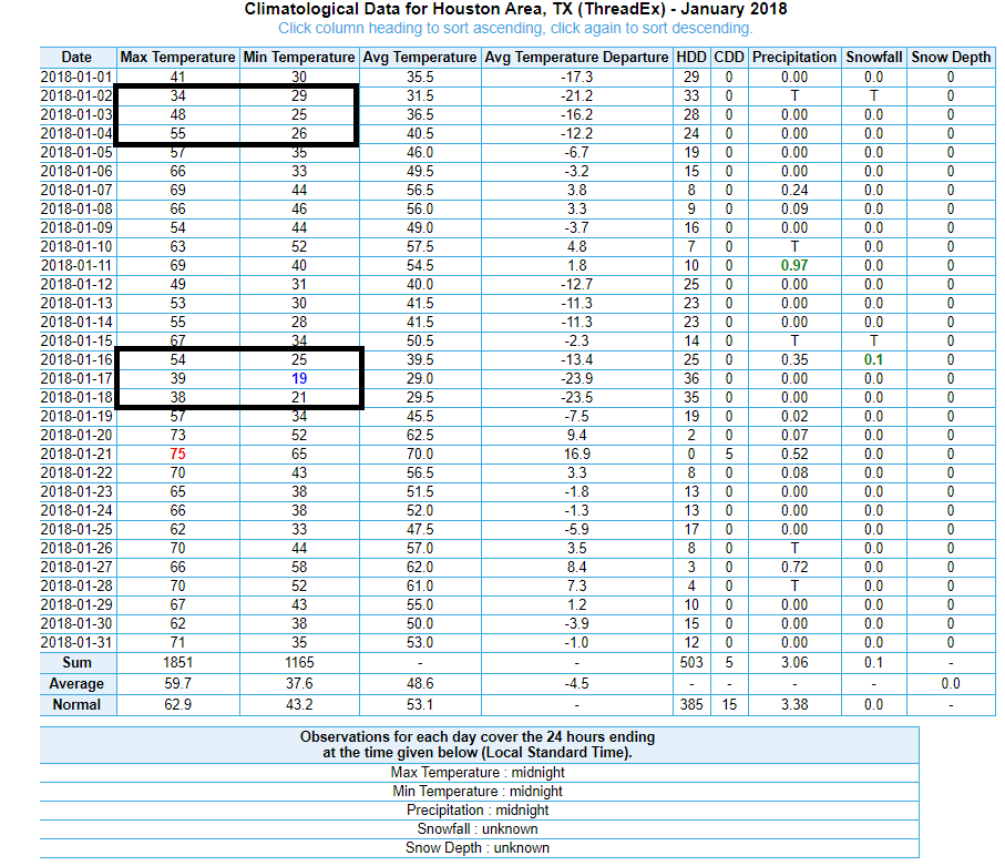
We’ve gotten a few comments from folks questioning how this upcoming cold could be classified as “coldest in years” when we just had cold like this in January 2018. Well, the reality is that January 2018, while impressive, was split up over 3 weeks and came with comparatively mild daytime highs.
January 2018 had its share of cold, including our coldest morning since 1996, but we weren’t able to string together a stretch quite like this week. (NOAA)
We did hit 19 degrees, which at that time was our coldest low temperature since 1996. We managed to reach the upper 30s on both days, which isn’t overly impressive. That event also came with snow, sleet, and ice. Impressive, but probably not historic.
February 2011
Coldest temperature: 21° on 2/2 Nights at or below freezing: 12 over 2 weeks
Another one we hear about is 2011. I remember February 2011 vividly because I moved to Houston for a time that month and arrived at the end of January. Quite the welcome. Houston officially bottomed out at 21 degrees on February 2nd. We registered 5 straight days with lows in the 20s from February 1-5 and 4 days from February 9-12. There was also an ice storm of sorts on the 4th. Eric wrote about it at the Houston Chronicle. I actually remember forecasting this and it being a really good lesson in the challenges of forecasting winter weather in the South.
While this was not really a record-setting event in Houston, other parts of Texas saw some impressive records. El Paso’s coldest February day on record was February 3, 2011. Dallas was plagued with cold and wintry weather as well, marring the 2011 Super Bowl.
December 1989
Coldest temperature: 7° on 12/23 Nights at or below freezing: 14 over 2-3 weeks
In pantheon of modern Houston cold snaps, December 1989 is front and center.
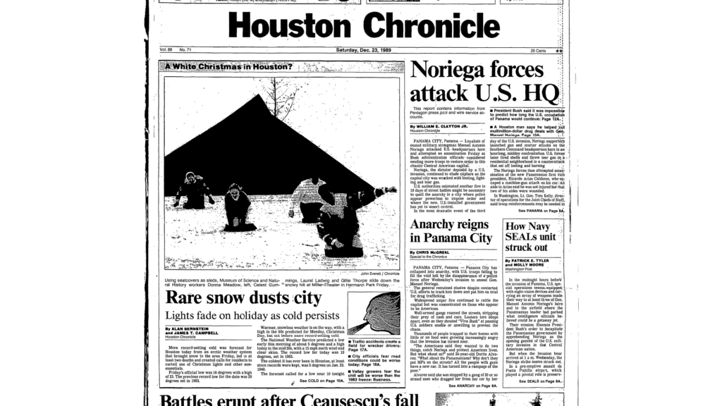
The front page of the Houston Chronicle from December 23, 1989, the day after Houston officially recorded 1.7″ of snow and the day that Houston recorded the coldest December day on record. (Houston Chronicle)
Six record low temperatures still stand from 1989.
December 12: 25°
December 13: 19°
December 16: 19°
December 22: 13°
December 23: 7°
December 24: 11°
December of 1989 was Houston’s coldest December on record back to the 1880s. Between crop losses and other damage, the cold of December 1989 was estimated at the time to cause $300 to $500 million in damage (up to $1 billion in 2021 dollars) in Southeast and Coastal Texas, according to NOAA’s December 1989 StormData publication. This event merits a whole post on its own, which we’ll hopefully one day get to!
December 1983
Coldest temperature: 11° on 12/25 Nights at or below freezing: 12, including 11 in a row to close the month.
The December 1983 cold wave was another hall of fame event for Houston. We closed the month with 11 straight mornings below freezing, including four full days that failed to crack above 32 degrees.
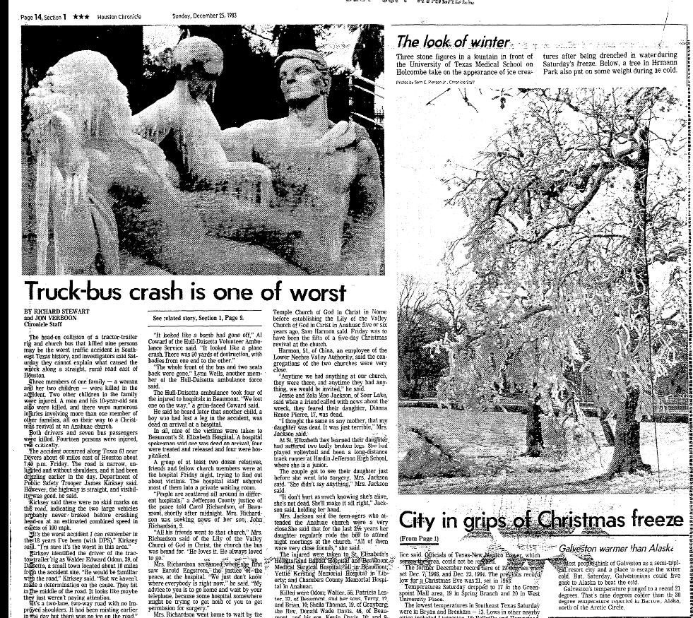
The Christmas morning Houston Chronicle featured pictures of fountains turned into ice sculptures in Houston. (Houston Chronicle)
The 1983 cold snap caused an estimated $50 to $100 million in damage in Texas at the time (up to about $250 million today). December 1983 is Houston’s second coldest December behind 1989. December 1983 was to Dallas what December 1989 was to Houston, leading to their coldest December on record.
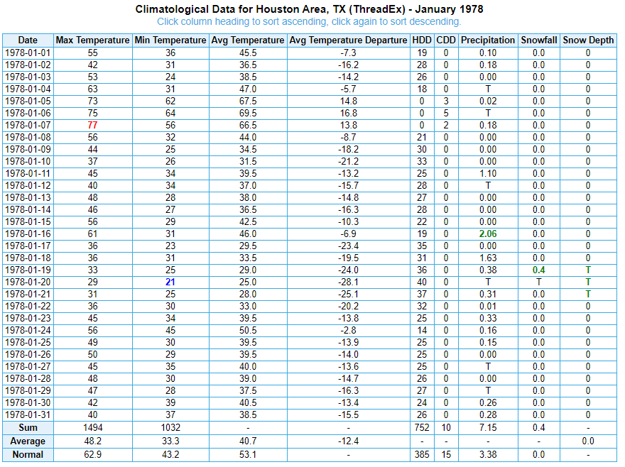
January 1978
Coldest temperature: 21° on 1/20 Nights at or below freezing: 20 (!) over the course of the month
The January 1978 cold snap doesn’t have much intensity on any single day, but it makes up for that in terms of duration, which ultimately led to 1978 being our coldest January (and coldest month) on record.
Frequent fronts ushered in cold, Arctic air through most of January 1978, which led to a low to moderate intensity, but sustained cold air outbreak over Houston. (NOAA)
The 1970s had some pretty amazing winters across the United States, and for Houston this was almost certainly the peak. Although, 1973 saw four days of snow in Houston between January and February.
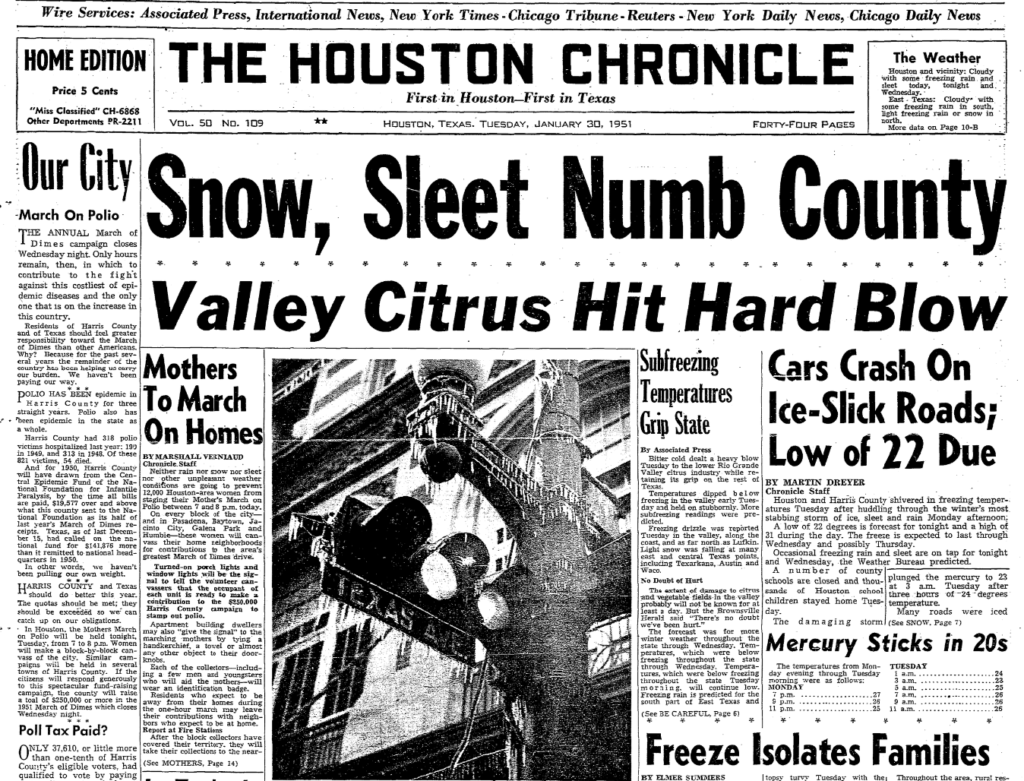
January-February 1951
Coldest temperature: 14° on 2/2 Nights at or below freezing: 6 in a row
January 1951 started off quite mild with 14 days in the 70s. The switch flipped on January 28, when temperatures dropped 40, and then January 29 when they kept dropping to 24 degrees. We then had four straight days below freezing all day long. The January 29-February 3 period remains Houston’s coldest stretch of 6 days on record, averaging 26.3 degrees.
January 30, 1951 front page of the Houston Chronicle, one of several days that saw the region dealing with disruption and damage due to ice and excessive cold. (Houston Chronicle)
In addition to the cold, what is likely the worst ice storm in city history led to serious damage and disruption. Almost an inch and a half of precipitation fell during the cold snap. Another event likely worthy of its own post.
January 1940
Coldest temperature: 10° on 1/19 Nights at or below freezing: 11 in a row
The 1940 cold snap came with snow on January 22nd, with up to 3 inches reported from Houston into southern Louisiana and more elsewhere in the states. Only twice has Houston seen 11 straight days of low temperatures at or below freezing: January 1983 and January 1940. The 1940 cold is notable for both intensity and duration.
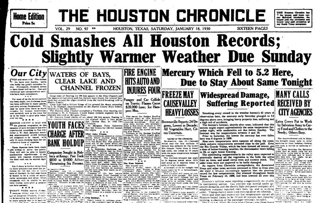
January 1930
Coldest temperature: 5° on 1/18 Nights at or below freezing: 8, coming in two 4-day waves
January 18, 1930 is Houston’s coldest morning on record, with a low of 5 degrees above zero. The cold came in two punches, this first strong one, followed by a second one a couple days later in which we bottomed out at 15 degrees on the 22nd.
The January 18, 1930 Houston Chronicle trumpeting the news of Houston’s coldest recorded day. (Houston Chronicle)
Five days after hitting 15 degrees, we were back up near 70, so further proof it won’t stay cold forever!
February 1899
Coldest temperature: 6° on 2/12 and 2/13 Nights at or below freezing: 9 in a row
The February 1899 cold snap covered most of the eastern half of the United States, and it could be deemed the granddaddy of them all in the South. Several records from that event still stand today, including the coldest on record for Amarillo (-16°), Dallas (-8°), Galveston (8°), and the Texas all-time record (Tulia was -23°, a record shared with Seminole in 1933). In addition to Texas, state records still stand or are shared today from this cold snap in Nebraska, Ohio, Louisiana, and Florida.
The February 13, 1899 edition of the Houston Post described the cold snap thusly:
“When a younger friend approaches him now and suggests to him, with a degree of profanity based on the length of time he has been exposed to the chilling, biting, nipping North wind, that ‘it’s pretty cold,’ the oldest inhabitant cannot yawn, draw closer to the welcome fire, and say, with an air of conscious superiority, ‘Yes, but away back in ’73 there was a norther that–.’ He has no recourse but to moodily assent, put a few more coals in the blazing grate and reflect on what has been, what might have been and what may be. And all this makes him sad, very, very sad.”
February 1899 is front and center in the pantheon of cold as well.
February 1895
Coldest temperature: 10° on 2/8 Nights at or below freezing: 12 over the course of 2 weeks
February 1895 was a memorable cold snap, with 4 daily records still standing today. But what set 1895 apart for Houston was our greatest snowstorm of 20 inches, which we conveniently wrote about back in 2017!
The final word
So, will 2021 join these memorable cold snaps? Probably. But ultimately, whether it really can join the ranks of a 1989 or 1983 or 1899 will depend on just how cold it gets Tuesday morning.