Today’s rain exiting as areas east of Houston are left to clean up from another flood

Good evening. The Houston area has been mostly fortunate through this rain event so far. We’ve managed to avoid very high impact rains, though we all finally got doused this afternoon and evening. Still, rain totals, while impressive were mostly manageable, aside from pockets of street flooding.
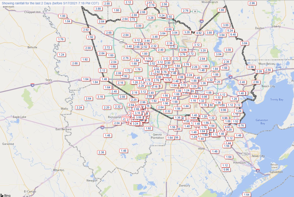
Rain totals for the past two days over the Houston metro area through 7 PM Monday. To view and zoom around yourself, visit harriscountyfws.org (Harris County Flood Control)

You can see that the highest totals for the event so far are in northeast Harris County, where over 6 inches fell in about 3 hours today just east of Huffman. All told, we’re lucky. After 13″ of rain fell in extreme southwestern Wharton County yesterday, it was Jefferson County, Liberty County, and the Lake Charles area that were hammered today.

Areas east of Houston pummeled

18.03″. That’s how much rain fell today near Fannett in Jefferson County, just off exit 838 of I-10. This is at least the third, if not fourth time this area has had houses flood — since Harvey.

Southeast Texas is vulnerable to floods, but what has happened in the Beaumont-Port Arthur area in recent years is something different, and as someone who knows several folks in that area, completely exasperating.
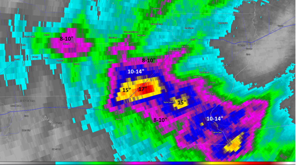
Radar estimated totals were north of 8 inches from Liberty into Jefferson County in East Texas. Similar totals fell locally on Lake Charles, LA as well. (RadarScope)

And if that were not enough, the Lake Charles area, which has just barely had time to move on from Hurricanes Laura and Delta was battered today as well.

The combination of 15″ of rain and debris clogged waterways and drains in the wake of the aforementioned storms has led to water in homes and businesses in Lake Charles.
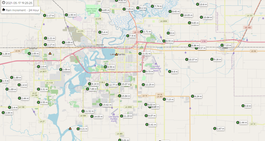
Lake Charles saw 10 to 15 inches of rain or more today, causing widespread flooding in that storm weary city, in addition to a few tornado warnings. (Calcasieu Parish Police Jury)

Repetitive disasters have become a hallmark of Southeast Texas and Louisiana, and it requires folks like us continuing to call attention to it without sugar coating it as “that’s just what happens here,” the linkages to climate change, and the reality that we need to continue to implement and expand mitigation measures. Or this will continue unabated.

Right now, we have just to get through this week.

Rest of tonight

Good news. The rain is tapering off from northwest to southeast as I type this, and we do not expect much, if any new development of storms overnight.

Tuesday

That said, we could see a cluster of storms find its way into the area by early morning Tuesday, as one model in particular (the HRRR) believes. I do think if we were to see that happen, it would be progressive, meaning a quick 1 or 2 inches of rain and then out. Granted, the ground is now saturated, so any rain of intense magnitude will be capable of producing flash flooding. But a quick moving system would be acceptable in this pattern. Additional storms will be possible later tomorrow afternoon or evening, though to be quite honest, the details are really fuzzy still. Tuesday will require a good bit of “nowcasting,” which means watching trends and making short-fused 12 to 18 hour forecasts at a time. Eric will update you in the morning.

Rest of the week

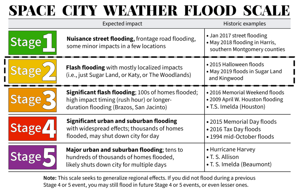
This week is a marathon, and we’re not sprinting to the finish. Wednesday and Thursday continue to look like active days with a combination of slower moving storms and saturated soils possibly combining to cause issues. We’ll remain in a Stage 2 flood alert unless something changes.

Just to underscore: As we’ve seen the last two days, these systems are relatively unpredictable with anything more than modest lead time. They are also capable of easily producing 2 to 4 inches of rain in an hour for more than one hour, and that will cause problems. So we know the potential for considerable heavy rain and flooding exists, particularly as soils saturate through the week. We still cannot tell you exactly where and when that will occur. We’ll continue to ask for your patience as we help you navigate the rest of this week. Stay safe.

Our next post will be Eric’s usual post on Tuesday morning.
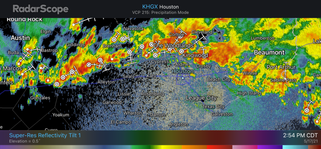
Storms sagging south into Houston metro area on Monday afternoon

The heaviest rainfall today has fallen east of Houston, from Chambers County to Lake Charles, Louisiana. Some locations have received more than 12 inches of rain and some serious flooding is underway.

Closer to Houston, a slow-moving band of showers has established itself just north of the Houston metro area. We expect this line of showers to slowly progress southward toward Interstate 10, and perhaps the coast, later this afternoon and evening. In the heaviest storms we’re seeing rainfall rates of 2 to 3 inches per hour, which is enough to quickly back up streets. Unfortunately, these storms will probably affect the central Houston area during the evening commute home. Plan accordingly.

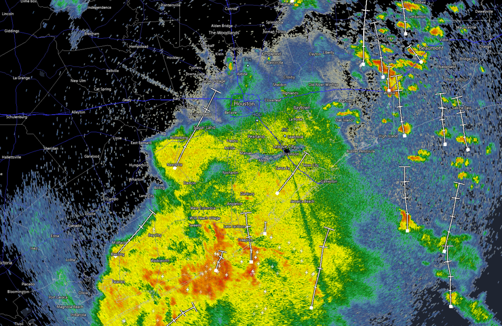
Radar just before 3pm showing a line of storms what will sag south. (Radar Scope)

These storms should begin to wind down as the sun sets, and we anticipate a reprieve overnight. Matt will have an update later today on the latest for what we can expect on Tuesday and Wednesday in terms of rainfall and flooding.

Houston under a Stage 2 flood alert this week with heavy rains looming

Good morning. We’re entering day two of a period that has the potential to bring significant rainfall and flooding across the metro area. The pattern is threatening because it may produce both short-term, intense rainfall as well as prolonged, widespread showers. Most of us should be fine in the end, but this kind of setup is worth monitoring very closely.

We are going to implement a Stage 2 alert on our Flood Scale for two reasons. While we do not think most of the area will see significant flooding, we do believe there is definitely the potential for localized flash flooding, especially on Wednesday and Wednesday night. Second, soils across the area are already wet, with reservoirs at full capacity.

Monday

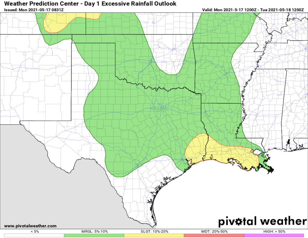
Our overall confidence in the forecast today is low. While there is the potential for heavy rainfall, there is also some drier air in the atmosphere, and this may limit activity over the Houston region to scattered showers and thunderstorms. In any case, the best chance for heavy rainfall will lie just east of Houston, along Interstate 10 and heading into Louisiana. For the Houston area, most of us can probably expect accumulations of 0.25 to 1 inch of rain. Skies will otherwise be mostly cloudy, with highs in the low- to mid-80s. Rain chances back off tonight.

Potential for excessive rainfall on Monday and Monday night. (Pivotal Weather)

Tuesday

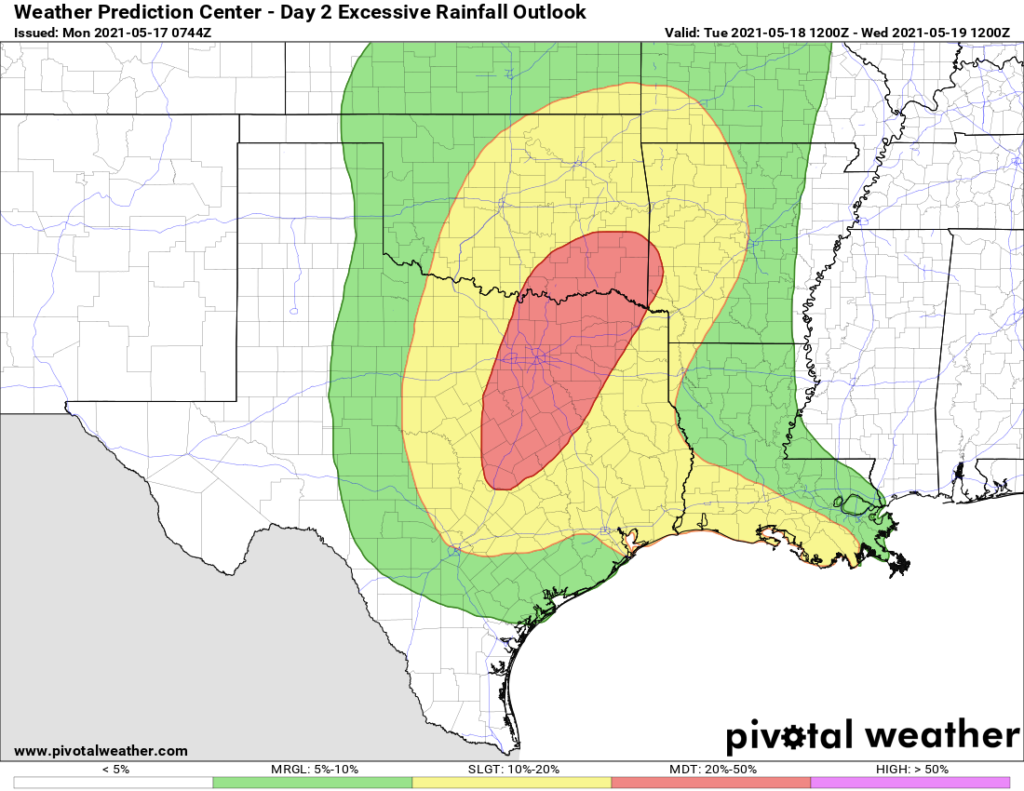
The disturbance in the upper atmosphere that is driving all of this unsettled weather will move closer to our region, and therefore the chance of heavy rainfall will increase somewhat on Tuesday, especially north of Interstate 10. (This could be a serious day for flooding in the Dallas-Fort Worth area). However, this does not mean the day will necessarily be a washout in Houston. I expect rainfall accumulations for most to average 0.5 to 1.5 inches, with the potential for more of course. Highs again will be in the 80s.

Potential for excessive rainfall on Tuesday and Tuesday night. (Pivotal Weather)

Wednesday

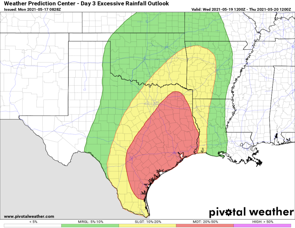
We still think Wednesday and Wednesday night will be the period that brings the best chance of heavy rainfall and flooding to the Houston metro area. This is when the upper-level low pressure system will pass more directly overhead. Basically, there should be enough moisture and lift to produce some very heavy rainfall. But whether the epicenter of this occurs along the coast somewhere from Matagorda Bay to Galveston, more inland over Houston, or north of The Woodlands, we just cannot say right now. I think most of the area will see 3 to 6 inches of rain from Tuesday night through Thursday morning, with the potential for some pockets of 10 inches or more. Where that occurs we just don’t yet know. This uncertainty is reflected in the large red area in the excessive rainfall forecast below.

Excessive rainfall forecast for Wednesday and Wednesday night. (Pivotal Weather)

Thursday and Friday

We think the potential for really heavy rain will start to dial back on Thursday morning as the upper-level low exits, but there should still be a healthy chance of showers and thunderstorms on Thursday and Friday. Both of these days should see mostly cloudy skies, with highs in the low 80s.

Saturday and Sunday

Some sunshine should return by the weekend, but I think we’ll still see at least some scattered to widely scattered showers on Saturday and Sunday. Highs will be in the low to mid-80s. Skies should turn mostly sunny by early next week.

Matt will have an update by around 7 pm CT on Monday.

Round one of rain winding down after hammering areas between Houston & Corpus Christi

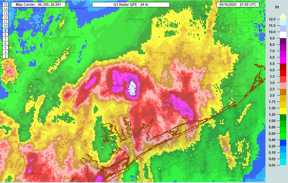
For the vast majority of the Houston area, today was pretty uneventful. Across Harris County, according to the Flood Control map, the max total was 1.64 inches along Buffalo Bayou at the Beltway. But as you went southwest along Highway 59, things escalated quite a bit. The max total in our region today was 13.47 inches (as of 3 PM) in Wharton County, just east of Ganado.

Total radar estimated rainfall today shows the 11 to 12 inches (which was actually too low) near the border of Wharton and Jackson Counties. Matagorda County and Bay City saw upwards of 3 to 5 inches or a bit more. (NOAA NSSL)

That wasn’t a typo. And a simple look at that map shows the problem and trouble with forecasting these types of events. You go from 13 inches just east of Ganado to about 5 inches in the town itself. Raise your hand if you expected 13 inches of rain in our regional neighborhood today. I sure didn’t. Neither did any weather model. But with these sorts of setups, this is exactly what can happen, and that’s one thing that makes forecasting in Southeast Texas so difficult sometimes. This is also why we’re being a little coy on details regarding this event. Because quite simply, they’re extremely difficult to predict, let alone try and communicate.

So the headline right off the bat here is that we are going to continue to tell you to expect us to activate our Space City Weather Flood Scale tomorrow. We remain unsure if it will start at Stage 1 or Stage 2, but Eric will update you in the morning on that. Likewise, the National Weather Service is holding off on Flood Watches for tomorrow given the uncertainty on how things evolve tonight. Which leads me to…

Tonight

What happens tonight? Well, the radar this evening still has a good bit of rain south of Houston. But the real ridiculous 2 to 4 inch per hour stuff seems to mostly be gone or pushing offshore.

The heaviest rain is slowly working its way to the coast and offshore south of Houston this evening, as of about 5 PM. (RadarScope)

There are some blobs of heavier showers east of Houston. And truth be told, that is the area I want us to watch closest tonight. One model in particular has been indicating that storms are going blow up after 3 or 4 AM along some lingering boundaries from today’s storms. And that would occur closer to Port Arthur or between Baytown and the Beaumont/Port Arthur area. So I would think that if we see heavy rain blow up again overnight, that would be the region to watch.

Tomorrow

Monday’s forecast will entirely dependent on what happens late tonight, so I’m just going to leave it at: There’s a good chance of scattered showers and thunderstorms tomorrow. Heavy rain is definitely possible. But the details are still very sketchy, and modeling disagrees on exactly who is at highest risk across Texas tomorrow. That said, we should see a little less chaotic weather tomorrow across the state than we have seen today (though the Panhandle will be at risk for some big storms).

Beyond tomorrow

Eric did a great job this morning summing up what I’d call the “known unknowns” of the forecast over the next several days. And to be honest, after digesting the models, not much has changed. That’s not terribly surprising. As I alluded to above, these types of patterns are notorious for being full of capricious details, and I fully expect certain modeled outcomes today to become outdated before too long.

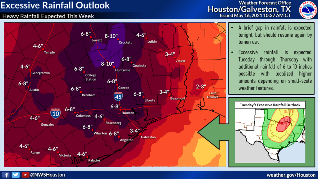
The NWS forecast from Monday through late in the week calls for about 6 to 10 inches on average, with higher amounts very possible over smaller areas, much like occurred today. (NWS Houston)

The National Weather Service outlook for total rain the rest of the week is above. I would view this as an “average” outcome. On average, your backyard could see as little as 3 or 4 inches of additional rain, but more likely closer to 6 or 8 inches. And some places could see much more than that. Suffice to say, this forecast is challenging, and we’ll keep you posted throughout as things evolve. You’ll want to stay plugged into the forecast. Our next update will be our usual Monday morning update from Eric.