A very wet week for Texas begins today

Good morning. We’re already starting to see the development of rain showers to our west and southwest, and this marks the beginning of what will be a very wet week for much of the eastern half of Texas. This activity will be driven by a slow-moving upper-level low pressure system and an increasingly moist atmosphere. There is a lot we still don’t know, but here’s an overview of what to expect.

Today

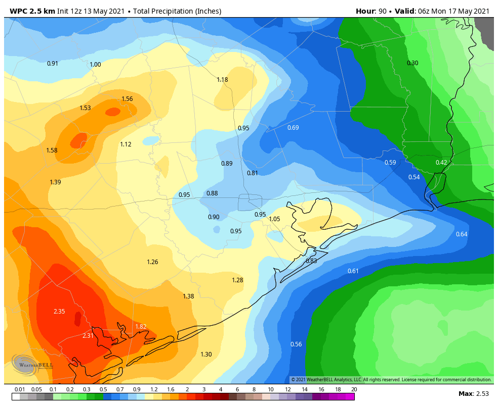
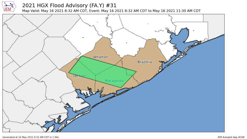
Storms will move from the southwest into the metro area later this morning, but we think their rainfall intensity will weaken a bit as they spread into Houston. Our general expectation is for 0.25 to 1 inch of rain for much of the Houston area, with higher totals to the southwest. The greater risk is over Brazoria, Wharton, and Jackson counties.

The National Weather Service has issued a flood advisory for this morning.

I-45 threat

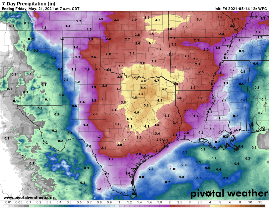
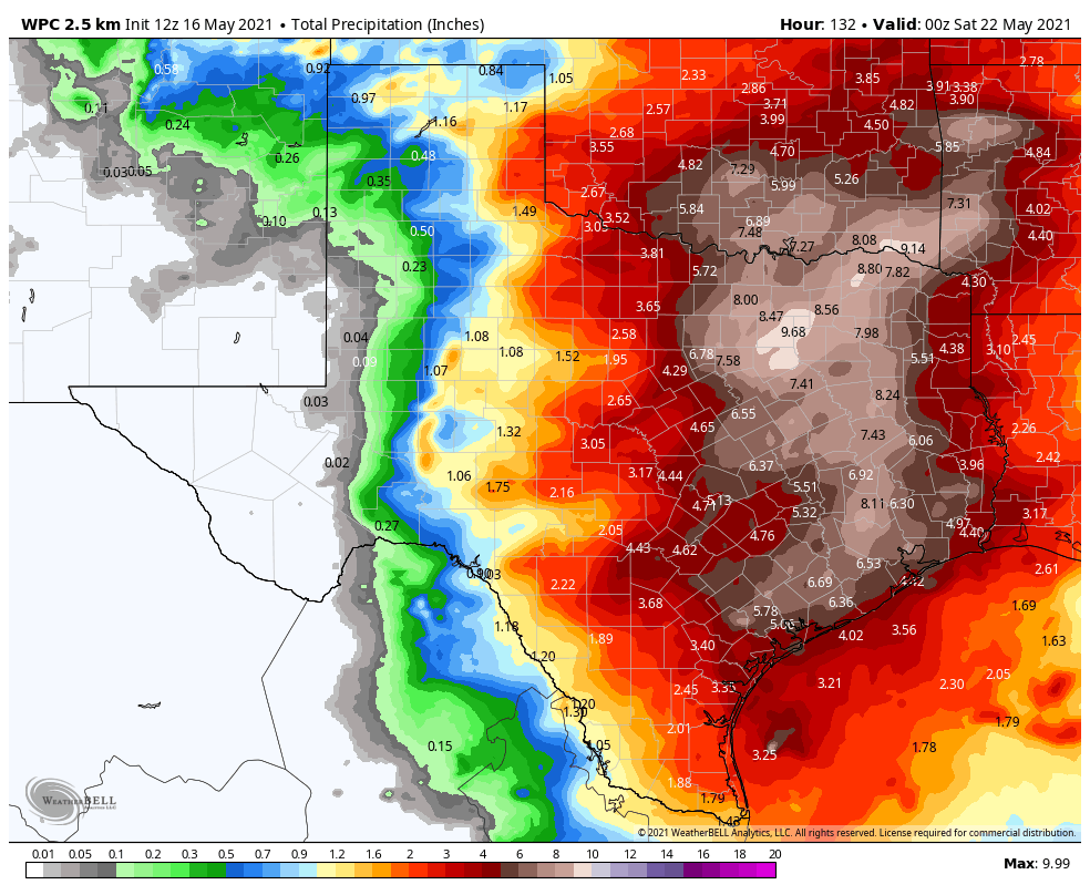
Much of the model guidance suggests that the biggest threat for heavy rainfall this week will come along the Interstate-45 corridor from Houston through Dallas, with 6 to 10 inches of rainfall coming between now and next Friday, with the potential for higher isolated totals somewhere. If you’re traveling to or from the Dallas Fort Worth area, take that into account.

Activity may spike Wednesday

The potential for heavy rainfall will exist every day this week given the overall atmospheric conditions, however we think the most active period will come on Wednesday or Wednesday night as the upper-level low pressure system moves directly overhead. This is when the potential for heavy rainfall should spike over the Greater Houston area, and we could see some flooding. However, given that we’re still more than three days from this time frame, we just don’t have that much confidence in the details for Wednesday and Wednesday night’s rainfall. We plan to implement a Flood Scale alert tomorrow, as we get better data.

NOAA rain accumulation forecast for today through Friday. (Weather Bell)

Rain chances continue through Saturday

Although the heaviest rainfall should end some time on Thursday, the threat of at least moderate rains should continue into Saturday before high pressure asserts itself.

Will there be flooding?

This is the big question. For most of the region, six inches of rain spread out over six days is really no problem. However, it becomes a problem if six inches come in a few hours, in which case we’ll see street flooding, and bayous begin to back up.

We’re starting from a point of reasonably dry soils, but if your area gets 1 inch today, another inch spread over Monday and Tuesday, and then 8 inches on Wednesday then there could definitely be problems. We just don’t know where this rainfall spike will occur. We’re fairly confident that some location between Matagorda Bay to Houston to Lake Livingston will see a bullseye of heavy rainfall on Wednesday or Wednesday night, and this will cause at least localized flooding. But where? We just don’t know yet.

Matt will have an update this evening, by 7 pm CT.

One more nice day before humidity returns and Houston moves into a wetter pattern

Well, we sure hope you got to enjoy the weather yesterday and hopefully today too. Mid-May fronts with cool, comfortable air masses feel like a rare treat. Our morning low of 62° at Bush Airport this morning is the coolest morning this late in the season since May 25, 2017 (60°). The humidity returns later today, tonight, and Saturday, and then rain chances will follow. Our area looks poised to enter into a prolonged unsettled weather pattern for at least least a week or so. Let’s walk through the forecast.

Today

Really, we will just have a nice day ahead today. Look for some sun after these morning clouds in spots dissipate. There will still be a fair number of clouds though this afternoon, and highs will be around 80° or in the low-80s, give or take.

Saturday

Saturday morning will start a bit warmer and a bit more humid than today or Thursday began. Morning lows will be in the 60s, if not 70° or so in most places. Look for a mix of clouds and maybe a bit of sun. If you have the option to choose between weekend days for outdoor plans, we would strongly suggest going with Saturday. While there will be a chance for some showers, mainly west or southwest of Houston, those chances are not especially high or long lasting. It will be warm and turn increasingly humid, with highs in the 80s.

Sunday into Monday

The forecast for Sunday is very challenging. This is mainly due to timing. The last couple days have seen the start time of rain slip in models from Saturday night to Sunday morning to now Sunday afternoon. What we know is that a disturbance is going to cross through our region, and it will likely bring most of us a period or two of showers and thunderstorms on Sunday through Monday.

We may have one area of rain Sunday morning and afternoon move into the area from the west. Rain may then taper off late on Sunday afternoon before another round fires up either Sunday night or Monday morning into afternoon. The exact timing is tricky, but we know most folks will see at least a little rain. You can see from the animation below how precipitable water or how much moisture is available in the atmosphere increases sharply through Sunday morning and afternoon, which will turn a slight rain chance into a fairly healthy one.

The amount of available moisture in the atmosphere steadily increases on Sunday from southwest to northeast across the area, meaning rain chances will build through the day. (Weather Bell)

Look for highs near 80° or in the low to mid-80s depending on exactly when it rains. Lows will be in the upper-60s to low-70s.

How much rain to expect Sunday and Monday? Always a difficult question to answer, but right now we could see a half-inch to inch on average with some localized places perhaps seeing as much as 2 to 3 inches of rain or even a bit more. Where those bullseyes occur is difficult to predict more than 12-18 hours out, so I won’t speculate on that this morning.

Rest of next week

The rest of next week will feature Texas under the influence of a pattern with lots of moisture around and several disturbances and a dreaded upper low passing across the state. That is a classic spring combination for periods of rain and thunderstorms. Why do I say “dreaded?” Because upper lows are notorious fickle and difficult to forecast. As the saying in meteorology goes “upper low, forecaster’s woe.”

Here’s what we know: The chance of rain will be high each day next week. But, it will not rain all day or perhaps even every day everywhere. More likely we’ll have a day with widespread, heavy thunderstorms separated by a day or two of more isolated or scattered activity. As of today, it appears that Sunday into Monday and later Tuesday into Wednesday have the highest odds of more widespread storms. But I’ve dealt with enough upper lows to tell you that this could easily move around, hence why we’re just blanketing each day next week with a rain chance. We’d expect rain chances to tail off a bit by next weekend.

The NOAA forecast of rainfall for the next week calls for about 1 to 3 inches on average, with highest amounts north. There will almost certainly be areas around Houston that see more than 3 inches of rain over the next week. (Pivotal Weather)

So how much rain should we expect next week? Well, it’s probably going to vary, widely. Some areas may see an inch or two, while other areas could easily see 4 to 6 inches of rain or even some more by Friday. On average, we would say about 1 to 3 inches should be expected. We don’t think those bigger ticket rainfall amounts will be especially widespread, and we don’t expect major flooding issues right now. But this is the type of forecast we’ll want to watch closely. If necessary, Eric and I will break out the flood scale, but it’s much too soon for that.

Meanwhile, we’ll do our best to try and isolate those heavier periods of rainfall that make travel difficult for you, and if we gain some confidence in those or rain amounts, we’ll also update this weekend.

What it’s like to have a whole-home generator installed in Houston

My wife and I first began thinking seriously about a whole-home generator last August, as Hurricane Laura barreled into the Gulf of Mexico and threatened Texas. Since we built a new home in League City in 2017, this was the first time a major wind storm threatened the upper Texas coast, and the fading memory of extended power outages during Hurricane Ike came back to me. Alas, the process of purchasing and installing a generator takes advanced planning, and it’s a big decision.

Eventually, we decided to go for it. So earlier this year I reached out to Reliant to inquire about a whole-home generator that is powered by natural gas. As a reminder, Reliant is the multi-year sponsor of Space City Weather. To note, I did not receive this generator for free, and I chose to purchase it with a portion of Reliant’s annual sponsorship fee. So, you can rest assured that my experience should be similar to yours.

Buying a generator capable of powering your entire home is a major investment. For the average homeowner in Houston, it will likely cost between $10,000 and $15,000. But for many, it may be a worthwhile investment—especially following the recent winter storm and annual threat of hurricanes for our area. With this post, I am going to describe the installation process and what you can expect if you decide to purchase a whole home generator.

We needed to put the generator on a stand to meet local code.

The process begins with a home visit by a generator technician. Reliant works with a Houston-based company, Quality Generators, and they sent Mike to my home in mid-January. Over the course of nearly an hour, Mike and I discussed my home’s power needs, existing power and natural gas lines, and potential solutions. I really knew nothing about this, so it was great to have Mike help us navigate the process. He explained all of the costs and fees associated with buying the generator and installing it.

On February 1, we agreed to contract, and I signed it. I paid half of the purchase price up front. Then we put stakes into the ground, an outline of where a platform would be built, and where the generator would go outside my house. We tentatively planned an installation later in the month. And then, the Valentine’s freeze came to Houston. We lost power for days. I remember standing in my darkened home office, as the temperature plummeted into the teens, looking out the window at those stakes.

After the freeze ended, installation began in March. All of this work was communicated well in advance, with a schedule clearly laid out. Any time I had a question, I would call Mike. I appreciated that there’s a local service phone number that a real person answers. I received regular updates, by phone, of what to expect, and when to expect it. Then, after each job, someone would check in to make sure I was satisfied.

First, a team of workers built a stand, which took a couple of hours. (Sometimes, a generator is installed on a concrete pad, instead). A few days later came the installation itself. This process was more laborious and lasted most of the morning. It involved power being disconnected to the home for about two hours, which I was told of in advance. But after this, the generator was ready to go.

Houston, we have a generator.

A whole home generator is a back-up plan. When the electricity goes off, for whatever reason, the generator kicks on within seconds. The lights come back on. Depending on the size of the generator it can power some, or all, of your home’s electricity needs. Theoretically, it should provide continual power through an ice storm, a hurricane, or any other type of disaster. I have fortunately not had to test that yet, but it is comforting to hear the generator fire up once a week to ensure its readiness.

And that really is perhaps the biggest benefit of having a generator. You never know when the power is going to go out, especially in a region prone to severe storms. Every time there is inclement weather in the forecast, there will always be a little bit of concern. When you have a whole-home generator, it takes the anxiety away. And reliable power is especially important considering that during inclement weather we want to continue providing you with timely updates on Space City Weather!

The bottom line is that buying a generator is costly, and a big decision to make. But if you’re considering it, you want to make sure you’re working with a company that is experienced and established. My referral from Reliant for Quality Generators was a painless process. The people I worked with were friendly, knowledgeable, and happy to answer all my questions. If there’s a problem, I’m confident they’ll be there to help.

If you’ve been considering a whole home generator, Reliant customers can receive 10 percent off with the first year of maintenance free. Learn more here.

Houston to enjoy a final spring like night, rain chances return this weekend

Good morning. Houston will continue to enjoy relatively dry and cool weather for another day or two, before the air mass begins to moisten with the onshore flow. Then, beginning Saturday night, the region will likely enter into a period with healthy daily rain chances.

Thursday

The air is dry at the surface, but at an altitude about 1 mile above there’s still plenty of moisture. As a result, skies today should remain partly to mostly cloudy, and this should help to limit highs to around the upper 70s for most. Winds will continue out of the north, and perhaps gust as high as 20 mph. Lows tonight will again drop into the low to mid-60s for most of the region.

Enjoy what is likely to be our last truly spring-like night, Houston. (Weather Bell)

Friday

Another pleasant, late spring day for Houston. Look for partly sunny skies, with highs around 80 degrees, and moderate northeast winds to start. Lows Friday night will be a few degrees warmer.

Saturday

The first half of the weekend looks good-to-go for outdoor activities, with partly sunny skies and highs in the low 80s. With southeasterly winds we’ll start to feel the humidity rise, however. There will be some very slight rain chances during the afternoon hours, with somewhat better chances overnight.

Sunday

An upper-level low pressure system will begin to impact our region Sunday, and this will drive a healthy chance of showers during the daytime. Most of the region will see rain, but I’m not overly confident in the details. I’d guess that much of the area sees about 1 inch or so, with the better chances for more rain to the west of Houston. Highs will likely reach the low 80s with mostly cloudy skies.

NOAA rain accumulation forecast through Sunday night. (Weather Bell)

Next week

The atmosphere should remain perturbed next week, and this will contribute to daily rain chances. Overall, I’m not expecting any sort of washout, but the region could pick up a few inches of rain next week, with mostly cloudy skies holding highs in the low 80s, and keeping nights in the low 70s. As always, details about individual, daily rain chances will come in due course.