Instead of training storms on Tuesday night, Houston got saved by a freight train

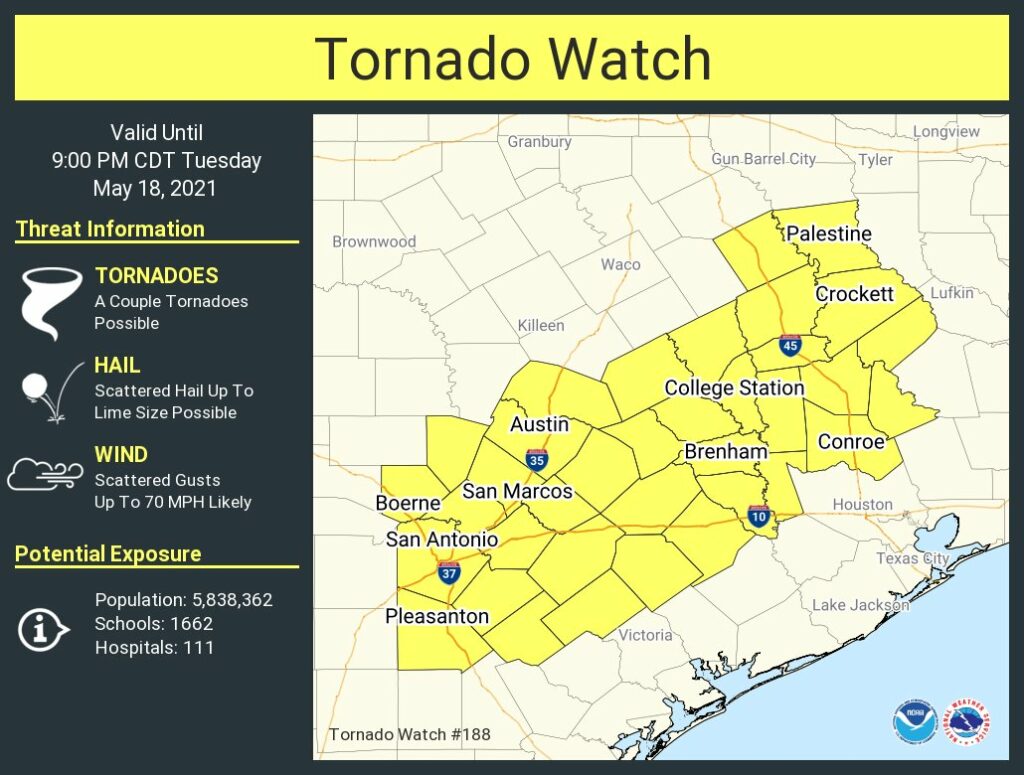
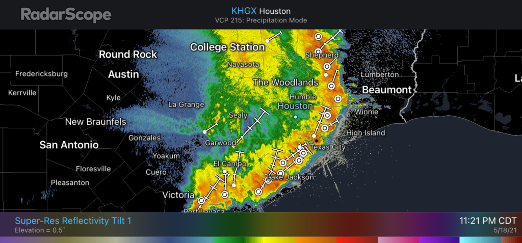
A ferocious line of storms roared through Houston on Tuesday night, producing a biblical amount of lightning, threatening with tornadoes, throwing down some hail, and dropping buckets of rain. But there was a silver lining—a silver lining that if I’m being honest I did not fully anticipate—with these storms. Rather than slowing to a crawl as they moved into Houston, these storms kept right on trucking. Yes, the storms produced intense rainfall rates as high as 4 inches per hour, but as the heaviest bands of rainfall kept moving on there simply was not enough time for serious flooding.

Houston radar at 11:21 pm CT on Tuesday night as the storms kept moving. (Radar Scope)

Can I get an amen?

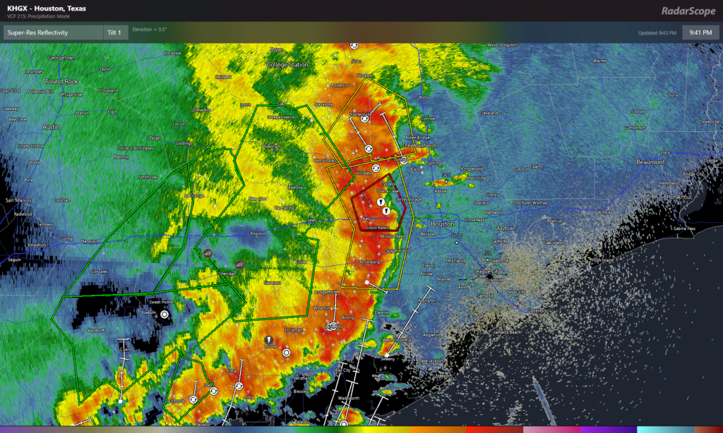
Seriously, I’m not sure I’ve ever been so happy to observe a radar absolutely lit up by bright red hues, indicating intense rainfall rates, as I was tonight. Because those storms kept on moving through. Instead of slow-moving storms that trained over our areas, we got a freight train. Choo-choo!

If I sound a bit loopy tonight it’s because I’m just so tired of writing about horrendous floods in Houston. Tax Day floods. Memorial Day floods. Halloween floods. Hurricane Harvey. Tropical Storm Imelda. Beta. It goes on, and on, and on. So tonight it feels amazing to write that Houston did not flood. I can write that this line of storms, which could have been very, very bad for the region, was by-and-large not bad. We had an hour of fire and brimstone, most everyone got 1 to 3 inches of rain, and then this system moved along.

So what comes next? The rainfall and threat of severe storms is moving to the east, and offshore, for the night. Some light to moderate rainfall may persist across Houston during the overnight hours, but this will not pose a significant flooding threat. Going to work, school, or other activities on Wednesday morning should be fine.

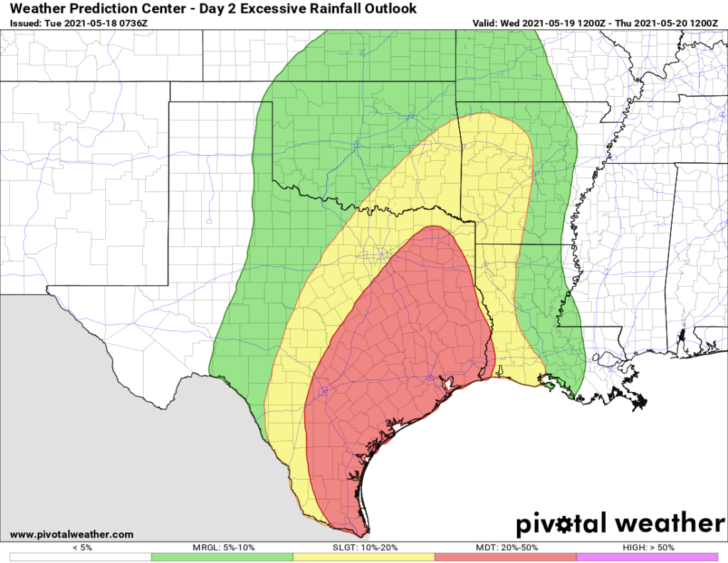
It looks as though we may see some additional rounds of showers and thunderstorms coming through later on Wednesday, after the atmosphere has a chance to recharge, and then again on Thursday. Given that I still have some slight concerns about areas just east of Houston on Thursday, I’m going to leave our flood scale alert at Stage 2 for now. But given more data by the morning we may be able to ratchet that back a bit. Matt will have an update by around 7 am or before on Wednesday.

Severe storms racing into the Houston area Tuesday evening

Storms are absolutely hauling their way into the Houston area tonight, faster than most of us expected earlier today. Good news, as you’ll see below. But they are intense. Rain is falling at a rate of 3 to 4 inches per hour on average in that intense red portion of the line bowing across Rosenberg, Cinco Ranch, and Cypress at 9:45 P.M.

Intense storms with torrential rains were moving into the Houston area at 9:45 P.M. Tuesday (RadarScope)

These types of rain rates will almost certainly produce street flooding across many parts of the region through Midnight, spreading east and south.

In addition, there have been multiple tornado warnings issued with these storms, including one storm that may have well produced a tornado just north of Brookshire earlier. Stay alert and aware, and seek shelter if a tornado warning is issued in your area. As of this writing, there is a tornado warning for the northwest side of the city through 10:15 P.M. Even with no tornado, strong, damaging winds are possible.

So, some good news about all this at least: That the storms are moving quickly is positive because, while it’s going to rain much of tonight, the super-intense, “floody” 2 to 4+ inch per hour rates will be short-lived over a given area. We can manage a steady rain. It’s when you get that overly intense stuff for more than an hour or two that things get out of hand.

Beyond tonight? Truthfully, I don’t have a great feel on what to expect tomorrow at this point. I think some of that will depend on how these storms evolve over the next several hours, and what happens back to our west overnight. Some models redevelop storms in parts of the area. Others give us a nice break between storm chances. It’s a tough call right now, so you’ll need to be fairly flexible and adjust with the forecast tomorrow. We do know that there will be more storms, but how intense and exactly where they hit matters a lot, and we just aren’t sure yet.

Eric will have an update on what’s happening here after midnight tonight.

Heads up Houston—it looks like the serious rainfall is coming tonight

Ok everyone, take a deep breath. The greater Houston region has experienced a nice reprieve from heavy rainfall today. That’s the good news. The bad news is that our atmosphere has recharged, and we are about to experience the worst of this potential flooding evening tonight and on Wednesday. The timing of all this remains in flux, but what follows is our best assessment for now.

Tuesday night

A pretty serious block of showers and thunderstorms are massing just to the west of Houston this afternoon, and we expect them to move toward our region this evening and during the overnight hours. These storms are being juiced by a slow-moving upper-level low pressure system, and they will have plenty of moisture to work with tonight.

We think most of Houston and the surrounding counties will see 2 to 5 inches of rainfall between now and sunrise on Wednesday, with higher isolated totals. These storms will be capable of producing intense rainfall rates above 2 inches per hour, which will quickly back up streets. Almost certainly some part of our region will see 10 inches of rainfall, or more, during the overnight hours. For now we are maintaining a Stage 2 flood alert, but this threat may need to be adjusted upward later this evening.

Although rainfall is the primary threat, some of these thunderstorms may bring severe weather as well. The National Weather Service has published a tornado warning that will remain in effect for the western half of our region until at least 9 pm CT tonight.

(National Weather Service)

Wednesday

It looks like tonight’s storms may work over the atmosphere, and if this happens we would expect to see a break in storms on Wednesday morning, possibly lasting into the afternoon hours. After this point it’s really difficult to say what will happen with confidence, but I think it’s reasonable to expect another round of storms Wednesday evening or during the overnight hours. Where this sets up, and whether it’s as intense as Tuesday night, is something I just don’t really feel comfortable predicting.

Thursday and beyond

We think the focus of these storms will begin to swing eastward on Thursday. For the overall event, most areas will probably see an additional 4 to 8 inches of rainfall, on average, from now through Thursday. This means some areas will see more, and it is in those locations we are most concerned about flooding.

The map below shows NOAA’s best guess for rain accumulation totals from now through Thursday night, but this should not be taken as gospel.

Matt and I will be continuing to work this event, and will update again by around 10pm CT Tuesday night.

We’re halfway through this May rainfall event, and still concerned about Wednesday

Good morning. We’re now approaching the half-way point of a multi-day heavy rainfall event that began Sunday and should wrap up on Thursday. We remain at a Stage 2 alert on our flood scale, which means the Houston region is likely to see flash flooding. The bottom line is that this air mass has produced explosive rainfall events the last two days (southwest, and then east of Houston) along the Texas coast, so it bears watching closely.

Tuesday

Although we should see showers and thunderstorms in Houston today, they may be less organized than on Monday. The primary threat for widespread, heavy rainfall is likely to lie north and east of the Houston metro area, where the atmosphere remains somewhat more unsettled. This area, north of Montgomery County and east of Harris County, is shown on the “excessive rainfall outlook” prediction below from NOAA for Tuesday and Tuesday night. Unfortunately, the area of “moderate” risk, denoted in red, could affect the Beaumont and Lake Charles areas that were hammered by heavy rainfall on Monday. Highs today will be in the mid-80s, with mostly cloudy skies.

Excessive rainfall outlook for Tuesday. (Pivotal Weather)

Wednesday and Wednesday night

We continue to believe that the period from Wednesday morning through Thursday morning will bring the heaviest rainfall to most parts of Houston. This is because of vigorous atmospheric lift, and a setup that allows a regenerative flow of moisture from the Gulf of Mexico. During this time frame we think rainfall totals will average 2 to 6 inches across the region. Our main concern, of course, is higher bullseyes that drop in bursts and lead to flooding. This will will definitely be possible given the moist and unstable air mass overhead.

Where will these bullseyes occur? As you can see in the excessive rainfall outlook for Wednesday and Wednesday night, we just don’t have a great handle yet on where the heaviest bursts of rainfall will land along the Texas coast, and points inland. When we have more definitive information to share, we will share it.

Excessive rainfall outlook for Wednesday. (Pivotal Weather)

Thursday and Friday

Whatever mess develops on Wednesday and Wednesday night will carry over into Thursday morning. Conditions should begin to improve during the afternoon hours, but if you’re looking for a guarantee of that, we can’t provide it. After the worst passes, we should still see on-and-off light to moderate showers to end the work week. However, these should for the most part not produce heavy, flooding rains. Highs will be around 80 degrees both days.

Saturday and Sunday

Saturday should be a lot like Friday, which is to say mostly cloudy with a healthy chance of light to moderate rain. We don’t expect a washout, by any means, but keep an umbrella handy. Some sunshine may break through on Saturday before the sun sets, and Sunday should see clearing skies. Rain chances on Sunday should fall back to around the 10 percent range, and remain low for several days. You’ll be ready for some sunshine, right?

Our next update will come by or before 7pm CT today.