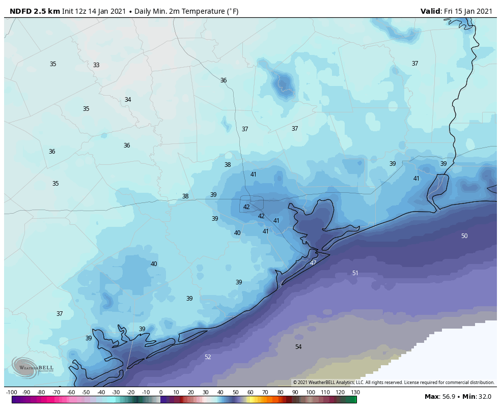
2019’s final weekend will be a mild one

Good morning. As we begin to close out 2019, it will continue to feel a bit springlike before a Sunday cold front cools us back off a bit.

Today

Dense fog is the main forecast issue, and it will continue to be the biggest problem today and probably tomorrow. Fog is almost everywhere this morning, and it will be stubborn and slow to clear from inland areas back to the coast.

Erratic visibility this morning, sometimes down to a quarter-mile in spots. (NOAA)

Some coastal or bay-adjacent locations and some other places, mainly south and east of Houston may hold on to fog well into this afternoon. Outside of the fog, it will gradually turn partly cloudy and quite mild. We hit 76° yesterday, and we will probably come close to that again today.

Saturday & Saturday night

Tomorrow should begin similarly to today with widespread fog, especially closer to the bays and coast. Again, that could linger into afternoon. As the day goes on, look for shower chances to slowly increase, mainly north and west of Houston. We’ll start in the 60s Saturday and by afternoon, look for highs perhaps near 80° in Houston. The cold front will push through the Houston area from northwest to southeast between Midnight and 5 AM or so Sunday. During that time, almost everyone should see at least some rain and thunderstorms.

Total rainfall should average between a quarter-inch and half-inch this weekend, with higher amount possible north and east of Houston. (Weather Bell)

We don’t anticipate too much rain when all is said and done, but a quarter-inch to half-inch or so on average, with lower amounts south and west of Houston and higher amounts north and east being the most likely outcome. Any fog risks will end behind the front as well. Some storms, especially north and east of Houston could be a bit strong overnight.

Saturday will warm up from the 60s in the morning into the 70s during the afternoon. Behind the cold front, temperatures will drop into the 50s by Sunday morning.

Sunday & Monday

Some lingering showers are possible Sunday morning. By afternoon, any remaining clouds should rapidly dissipate, and we are going to be left with delightful weather for both the second half of Sunday and Monday. Look for sunshine and high temperatures in the 60s both afternoons. Morning lows will be in the 40s for most folks on Monday morning, though outlying areas could sneak into the upper-30s.

New Year’s Eve & Day

Yesterday, it appeared that a storm system would begin to approach on Tuesday, bringing a slight chance of showers for New Year’s Eve. That has slowed down today, pushing any rain chances to Wednesday. The image below shows the last 6 runs of the European model’s forecast of rainfall from 6 PM to Midnight on New Year’s Eve

Models are trending drier for New Year’s Eve now, holding off on rain until later New Year’s Day. The forecast may change more between now and Tuesday, however. (Pivotal Weather)

What you’re seeing is that until the most recent run, the model indicated shower chances. The latest version holds the rain back for another 12 to 18 hours. What does this mean? It means check back with us on Monday while this system’s timing gets sorted out over the weekend. We don’t trust this model explicitly and would lean toward increasing rain chances after the calendar flips to 2020, with rain becoming most likely during the afternoon and evening hours of Wednesday. Either way, our chances of a widespread, meaningful rain and some thunderstorms continue looking higher as we move into the new year.

Daytime highs should be in the 60s on both days. For New Year’s Eve celebrations, look for temperatures dropping into the upper-40s. We will update this forecast for you on Monday for sure.

Hitting a brief speed bump in our beautiful late autumn weather

We have continued to amass nice stretches of weather here in Southeast Texas over the last couple weeks, as our seemingly endless gorgeous autumn continues. We have one small bump in the road to get through today and perhaps tomorrow before we resume our regularly scheduled programming for a few more days.

Today

We’re starting off a good bit warmer this morning than in recent mornings.The map below shows the difference in temperature between 5 AM this morning and 5 AM Thursday morning.

This map shows 24 hour temperature changes as of 5 AM Friday. Some places are 25° warmer than they were on Thursday morning. (NOAA)

Locations east of Houston are running about 10 to 15 degrees milder than yesterday morning, while from Houston to points west, temperatures are as much as 20 to 25 degrees warmer. This is because clouds have increased overnight. While there may be a few pockets of sunshine around this morning, expect those to fade as the day progresses.

It may look like rain is imminent at times today, but it may take a bit before you actually see any reach the ground. The air is still a bit dry after our recent nice weather, so it needs some time to saturate. Overall, a few light showers, light rain, or sprinkles may be observed today but for the most part, it likely won’t rain much before sunset. The best odds of any measurable rain will be west or well south of Houston.

Cloud cover should keep temperatures in check. Look for highs in the 50s for most folks.

Tonight

Houston will be caught between the best ingredients for rainfall tonight, with one batch to our south and another well east into Louisiana. Look for scattered showers here in the Houston area. The best chance for rainfall and some thunder will be to Houston’s south, closer to Matagorda Bay or Corpus Christi. There could also be some scattered showers north and west of Houston at times through the night. By Saturday morning, it is likely some of us will have seen a little measurable rain, while some others may not have seen much of anything. Overnight lows tonight will probably be in the mid- to upper-40s.

Saturday

It appears that Saturday will be a continuation of this trend. The best chance for more nuisance rain will be along the coast or south of Houston, again toward Matagorda Bay or Corpus Christi.

Rain chances should end by Saturday afternoon. Total rainfall is not going to be anything spectacular for most of us.

Total rainfall should be a few tenths of an inch (at best) through Saturday evening. Some places south and west of Houston could see a quarter-inch or half-inch or so. (Pivotal Weather)

Saturday won’t be the prettiest, as clouds dominate with highs in the 50s. We could see a few breaks of sun in the afternoon. A bit of a breeze could develop along the coast later Saturday and linger into Sunday, with some 15 to 20 mph gusts possible.

See full post

Just another fine fall weekend ahead for Houston!

Keep doing whatever it is you’re doing because it’s working. We keep getting extended nice stretches of weather. We are in the midst of one now, and it appears we will have another nice stretch coming to Southeast Texas next week.

Today

This morning is starting off quiet. Watch for perhaps a couple pockets of fog mainly west of the Brazos River. Otherwise, look for decreasing clouds through the morning. The sun will be back out virtually in full by afternoon, and it will be delightful. High temperatures will top off in the 70s, though a bit cooler at the coast.

Weekend

Saturday should be sunny. Sunday should see fair skies but probably a few more clouds. High temperatures will be in the low- to mid-70s on Saturday. Sunday will see onshore flow kick in ahead of our next front, so look for daytime highs to perk up some, possibly approaching 80° in some spots, especially west of Houston.

Sunday has a chance at reaching 80° in parts of the area! (Pivotal Weather)

Morning lows will be in the 40s Saturday morning and mid-50s Sunday morning.

Early next week

Our next cold front (it never gets old saying this) is on the way Monday. While the timing can change, it looks like it will hit Houston in the mid-to-late afternoon. The front will come with scattered showers and thunderstorms but perhaps not the widespread soaking rain we could use. I would anticipate perhaps a quarter-inch of rain, with a few places seeing up to a half-inch or so. We will update you on Monday.

Behind the front, it will turn sharply cooler once more. Look for Monday’s temperatures to start very warm (near 70°), warm into the mid-70s, then crash into the 40s Monday night behind the front.

See full post

Chilly temperatures return to Houston for midweek

Good Tuesday morning, and welcome back to winter. Matt here, filling in for Eric today, and I bring you one of our grayest, chilliest days in a while. By my count, the last time we had a day anything like this was at least back on November 13th, when we stayed in the mid-40s most of the day with clouds and some occasional light rain. Today will carry that vibe.

Today

The front is through, and temperatures have plummeted since yesterday’s record high of 83° at both Hobby and Bush. In fact, we’re into the 50s this morning everywhere except for the immediate coast. Temperatures in the 40s are not far behind.

Temperatures as of 5:45 have fallen into the 50s everywhere except the coast, with 40s not far behind. (NOAA)

In addition to chilly temperatures, we’ve got some pockets of heavy rainfall around the area this morning.

A radar loop as of 5:50 this morning shows some heavy downpours north and west of downtown Houston, with more heavy downpours to the south moving into Brazoria County. (RadarScope)

The rain is moving fast enough and it’s been dry enough of late that there isn’t any flooding to worry about, but do be prepared to encounter some wet roads and puddles this morning.

Dress warmly today. Periods of rain and occasional downpours will be possible through about midday before we transition to more of a light rain or drizzle, ending in the afternoon. Temperatures will slowly drop from where they are this morning, into the 40s this afternoon. With a fresh breeze out of the north at 15 mph, gusting to 20-25 mph, it will feel even colder.

Tonight & Wednesday

Low clouds should persist into tonight. The combination of lingering clouds and a little leftover wind should keep temperatures a bit above freezing for most areas outside. Look for Wednesday morning lows to bottom out near 40 in Houston, upper-30s in the surrounding suburbs mostly outside the Beltway, low-40s at the coast, and then mid-30s in farther outlying areas. I think even the Metro Houston icebox of Conroe will escape freezing temperatures tonight.

Overnight lows will be near 40° in Houston and colder in outlying areas north and west tonight into Wednesday morning. (Pivotal Weather)

Wednesday will be a fine late autumn slash early winter day. Expect any remaining low clouds to scour out and the sun to take over. Temperatures will warm into the mid- to upper-50s with much lighter winds than Tuesday.

See full post