After a surprisingly chilly Sunday, temperatures are fairly cold this morning across the state of Texas, with parts of the Houston dropping to about 50 degrees in the wake of a front. The region will see another decent cold snap this weekend as we reach the end of April. Knowing what is coming over the next five months, it’s nice to see April doing spring-like things.
Monday
We will see mostly cloudy skies today because, just above the surface, winds have already turned to come from offshore, pumping moisture back into the atmosphere. However, at the surface winds will remain from the northeast for the most part today, and this will keep our air reasonably dry, with highs in the low 70s. Temperatures tonight will only drop down to around 60 degrees with this warmer flow taking hold at the surface.
Tuesday
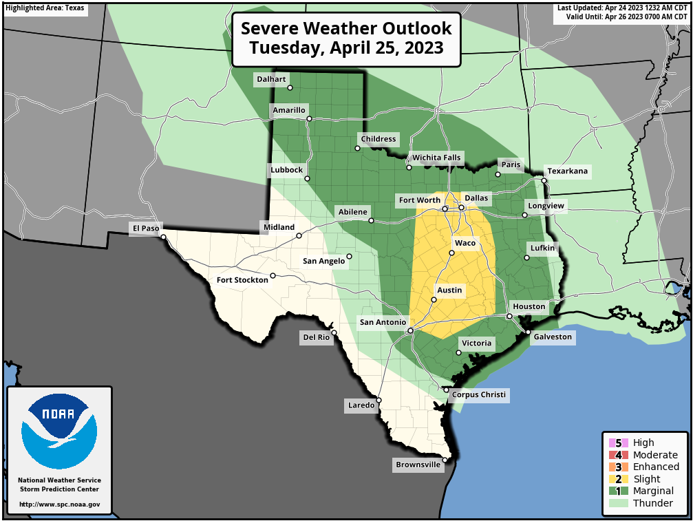
The aforementioned moisture in the atmosphere will combine with an atmospheric disturbance to produce a healthy chance of showers, and possibly some thunderstorms on Tuesday and Tuesday night. I think any rain will be fairly scattered during the daytime on Tuesday, with partly sunny skies helping to push daytime highs up to nearly 80 degrees. Showers may become more widespread Tuesday evening and overnight. While we cannot rule out a chance of severe weather in the Houston metro area, including hail and damaging winds, the more pronounced threat will be to our west, particularly along the Interstate 35 corridor. Lows on Tuesday night will only drop into the mid- to upper-60s.
Wednesday
Never a dull day this week. Why? Because while Wednesday will start out with fairly calm weather and partly sunny weather, a front will be approaching from the west. Again we’ll not be in the bullseye for high storm chances—those will be off to the north this time—but we probably can expect some showers and thunderstorms on Wednesday night. Expect daytime highs in the low 80s, with overnight temperatures in the 60s.
Thursday
After any showers associated with the front clear during the morning hours, we’ll probably see a partly sunny day, with a smidgeon of drier air, and highs in he upper 70s.
Friday
Thursday’s front will be short-lived, so look for highs to push back up into the lower 80s, with nighttime temperatures in the low 60s. Another, slightly stronger, front looks to push in on Friday night setting the stage for a cooler weekend.
Saturday and Sunday
The weekend will feel distinctly spring-like even though we’re coming to the end of April. In the wake of the front, look for highs in the mid-70s on Saturday, likely with clearing skies. Lows Saturday night will probably bottom out in the mid-50s, and Sunday will top out at around 80 degrees with sunny skies.
If you’re riding the MS-150 bike event out of Houston this weekend, the one concern is winds. It’s too early to be certain, but I think there probably will be decently strong winds from the north on Saturday, perhaps gusting to 25 mph. Similar, but less gusty winds, will be possible on Sunday. Fortunately the likelihood of rain or any storms this weekend is very low at this point.
Next week
The start of next week should see a warming trend, with temperatures eventually getting into the mid- to upper-80s, probably. Then? Perhaps some sort of front to cool things down. We’ll see.