I don’t want to talk about this week’s weather, I want to talk about next week’s front and rainfall

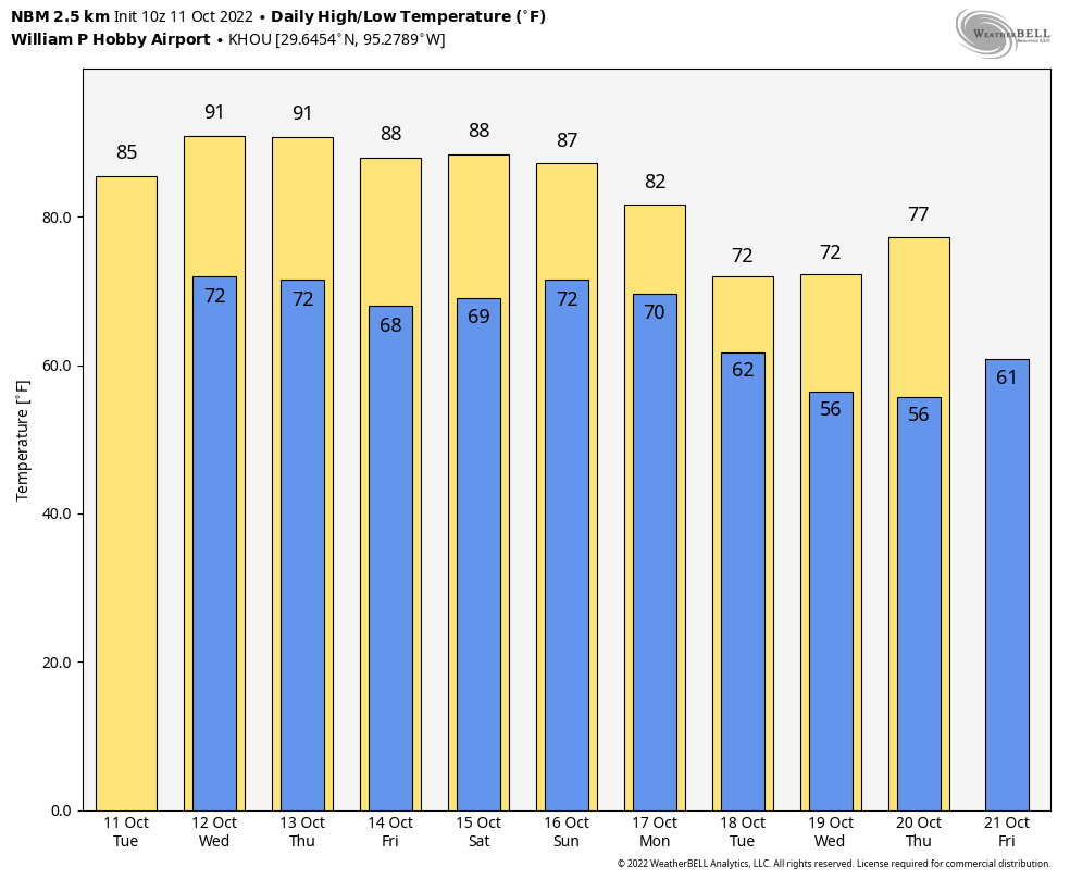
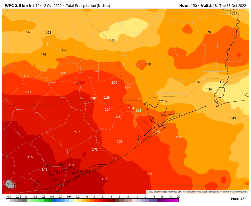
Good morning. Houston faces four or five more fairly warm to hot days—today should be the hottest—before the arrival of a fairly robust cold front. The really good news about this front is that there should be plenty of atmospheric moisture to work with, so our confidence has begun to increase in a pretty healthy amount of precipitation accompanying the front. While it’s too early for precise information, 1 to 3 inches of rain would go along way toward ameliorating some of our recent dryness.

Wednesday

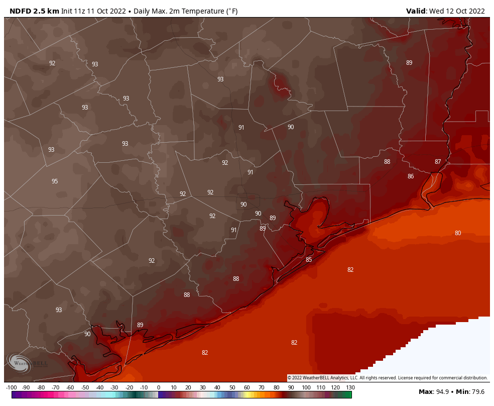
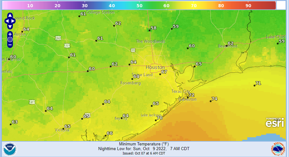
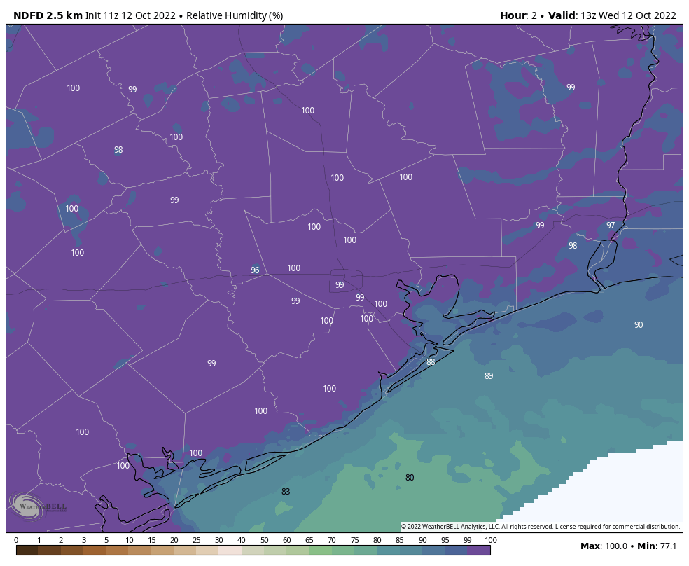
Today is going to be pretty muggy as tropical moisture moves into the area. Highs should push into the low 90s for much of the region, with partly to mostly sunny skies, and some of the highest humidity levels we’ve seen in a while. Winds will be light, generally out of the southwest. A weak front will approach the region this evening, and this should spark a 10 to 20 percent chance of rainfall late this afternoon, evening, and overnight. Don’t expect rain, and then you won’t be disappointed when it fails to materialize. Lows will drop into the low 70s tonight.

Relative humidity is pretty much 100 percent on Wednesday morning. (Weather Bell)

Thursday

As a modest amount of drier air filters in on Thursday, we can expect sunny skies and highs near 90 degrees. The evening hours should be pleasant, with drier air and temperatures in the upper 70s. Overnight lows will drop into the mid- to upper-60s for the region.

Friday

Drier air starts to go away as winds turn to come from the southeast. Look for sunny skies and highs of around 90 degrees. Lows on Friday night will be a couple of degrees warmer than Thursday night.

Saturday

The first half of the weekend will see humidity levels rise, and partly sunny skies. As moisture levels rebound, we will probably have about a 20 percent chance of rain. Look for highs near 90 degrees once again, with a warm and humid night.

Sunday

Rain chances on Sunday are better, perhaps 40 percent, but I expect showers to remain fairly scattered. Look for more clouds, and as a result highs in the mid-80s.

Monday and beyond

The stronger front looks set to arrive some time on Monday, and combined with a moist atmosphere, this will bring our region’s best chance of rain in more than a month. Forecast models are still quite variable in their outcomes, but I think much of the region should see at least 1 inch of rain, with the potential for more. I am quite optimistic about this right now, but since this remains five days out we just can’t offer any guarantees.

Colder and drier air after the front is coming, however, and I expect Houston to see at least a few days with highs in the 70s and lows in the 50s. Some inland areas may even touch the 40s by Wednesday or Thursday morning, if you can believe that.

Preliminary NOAA rainfall accumulation forecast for now through Tuesday morning. (Weather Bell)

Tropics

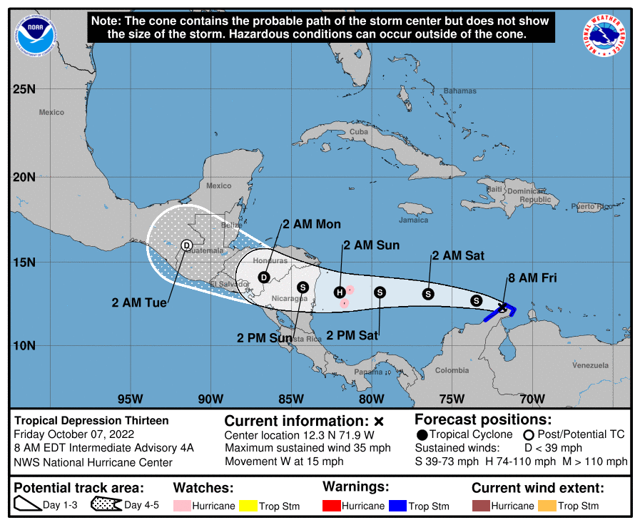
Tropical Storm Karl has formed in the Gulf of Mexico. Should you be concerned if you live in Texas? No. We told you more than a week ago that the Texas hurricane season was over, and when we’re that definitive on something you should probably trust us. The storm could bring heavy rainfall and flash flooding to parts of the Veracruz and Tabasco states on Mexico this week, however.

Houston’s long run of 90-degree days in 2022 may soon come to an end

Houston recorded its first 90-degree day this year way back on April 5, a little more than six months ago. Since then Houston has recorded a total of 130 days of 90-degree weather, or warmer. My bold prediction this morning is that, after a few more such days, we’re done with 90-degree temperatures for 2022. Put another way, after this week, we can chunk 90-degree weather in the bin for about six months.

Tuesday

Alas, we’re not there yet, and we will see rather warm weather this week. Look for highs today in the upper 80s, with mostly sunny skies. It won’t be full-on humid outside, but the air will start to feel more moist than it has in days past. Winds will be light, out of the southeast. Low temperatures tonight may not fall below 70 degrees in the city of Houston.

Wednesday

This is going to be a really hot day for mid-October, with high temperatures in the low 90s. Skies will be partly sunny and humidity levels are going to surge. So be prepared to sweat when you step outside. This moisture will help lead to some cloud cover, and there is a slight potential for some rain during the daytime on Wednesday, but it is only 20 to 30 percent, so if you see any rain, you should feel lucky.

Highs on Wednesday will be hot and steamy. (Weather Bell)

Thursday and Friday

A weak front arrives by Thursday to bring some relief. It won’t be much, but it may knock highs back into the upper 80s, and bring enough dry air to make the humidity a bit more tolerable. Nighttime lows should drop back into the upper 60s for Houston, with slightly cooler weather inland.

Saturday and Sunday

Summer’s last hurrah? Probably not, as we’re still going to see warm weather in 2022. But this will be one of the last truly warm weekends of the year with highs in the upper 80s to 90 degrees, and mostly sunny skies. A chance of rain returns to the forecast on Sunday as atmospheric moisture levels increase, and our weather becomes more disturbed due to the approach of a stronger front.

Change is coming? (Weather Bell)

Next week

My confidence is increasing in the arrival of a real cold front next week, probably on Monday. This will bring us our best chance of rainfall in what seems like forever, although it is still too early to have much ability to predict how much. It’s not out of the question that much of the area sees on the order of 1 inch, however. I think lows will drop into the 50s next week, in the wake of the front, but again that’s not something we can lock in just yet. But, I’m hopeful.

Only modest rain chances this week, but we see some promising signs in the longer-term forecast

Good morning. As Matt wrote last week, our region’s start to fall is the driest on record. Unfortunately, I do not expect that to change much this week, although some modest rain chances will return. This week will also be warmish, with a few days flirting with 90 degrees. However, I’m starting to see some potential for our weather to turn wetter and cooler about one week from today. Emphasis on potential.

The state of Texas is enjoying a pleasant start to Columbus Day with these sunrise temperatures. (Weather Bell)

Monday

Temperatures have generally fallen into the low 60s this morning, although the usual locations further inland are seeing lows in the upper 50s. Today should be similar to Sunday in that we see highs in the upper 80s with mostly sunny skies, and light northeast winds of 5 to 10 mph. As some dry air holds on most of the city should drop into the mid-60s tonight, with clear skies.

Tuesday

Highs and skies will be similar to Monday, with temperatures in the upper 80s and mostly sunny skies. However we’re going to see southeasterly winds and a corresponding increase in humidity. As a result we can expect lows Tuesday night to be warmer, possibly only dropping to around 70 degrees.

Wednesday

There is an honest-to-goodness chance of rain on Wednesday, but unfortunately it’s probably only about 30 percent. The forecast has trended drier, in terms of rain, despite a decent influx of moisture from the Gulf of Mexico. Some areas may pick up a quarter of an inch of rain, or so, but I think much of the region will only see some clouds. At the same time, this moisture will really bump up humidity levels, so this is going to feel like a pretty warm summer day with highs perhaps in the low 90s. It’s difficult to see too many more days like this in 2022, so you summer lovers make sure and soak this one up.

NOAA rain accumulation forecast for now through Friday. (Weather Bell)

Thursday and Friday

A weak front should push into the area early on Thursday. Don’t expect miracles from this one, but it should be enough to drop temperatures back into the upper 80s, with drier air, and push nighttime lows into the 60s. Mornings and evenings should feel pretty nice.

Saturday and Sunday

The front should wash out by the weekend, so we’re going to see humidity levels start to return. I’d expect highs somewhere in the mid- to upper-80s with mostly sunny skies. I’m honestly not sure about the potential for rain. With the onshore flow I think it’s possible, but for now I’d peg daily chances at only 20 or maybe 30 percent, with perhaps a bit higher likelihood on Sunday. We’ll see.

Next week

We’re getting to the limit of weather forecast models by Monday or Tuesday of next week, but there is a decent signal for potentially a stronger front to push into Houston around that time, accompanied by a pretty healthy chance of rain. If this happens I think much of the area could see a nice soaking, followed by cooler weather. The bottom line is that right now we may be seeing a light at the end of the tunnel for a very dry fall. Hopefully it’s not an oncoming train.

Houston’s driest start to meteorological fall in nearly 70 years

Since September 1st, Houston has registered a mere three-quarters of an inch of rain, which is the driest start to meteorological fall (September-November) since 1953 (0.47″). More recently, 1992 only saw 1.08″ and the drought-ridden 2011 only saw 1.28″ of rain in that same time period. It’s the fifth driest start to autumn on record.

Slide the bar on the image above to see the week to week comparison of drought coverage (and statistics) across the Houston area. (NOAA)

As you’d expect, with yesterday’s drought monitor update, coverage of drought conditions in the Houston area increased by over 30 percent week over week. We need rain. October is normally our second wettest month of the year (trailing only July). We average over 5 inches of rain in a typical October. Hopefully we are able to cash in on some rain chances next week. Otherwise, watch for drought coverage to expand even more in the days ahead.

Today

No rain in the meantime. Houston officially hit 90 degrees on Thursday, and we’ll feel a touch hotter today. Look for low 90s and a bit of humidity. Clouds will mix with some sun and haze otherwise. Pollen remains painfully high due to ragweed, and air quality will remain on the poor side in the morning via smog and in the late day via ground ozone.

Weekend

Saturday looks fairly similar to Friday in most aspects. Morning lows may be a touch warmer due to clouds. Daytime high temperatures may be a couple degrees cooler, but we’ll see a good deal of sunshine emerge. Subtly, a weak front, which crosses the area later Friday, will start to usher in a reinforcing shot of dry air for the weekend days. We should notice a slightly more pleasant morning on Sunday with lower humidity during the day, despite highs in the still in the mid or upper-80s.

Morning lows on Sunday will be generally in the 60s with some 50s likely in outlying areas east, north, and west of Houston. (NOAA)

Aside from it being a bit warmer than usual, all weekend plans should be fine.

Early next week

Monday looks a lot like Sunday and Tuesday a lot like Friday. Does that make sense? Still pleasant but warm Monday and then warmer and a little more humid on Tuesday.

Mid to late next week

On Wednesday, it appears we actually get a legitimately strong surge of humidity into the area, which will make it feel more like late summer. Wednesday and Thursday seem unlikely candidates for “comfortable” weather. Look for upper-80s by day and 70s by night. Beyond that, there are questions as to the timing and strength of a cold front and how much moisture it will offer. That will determine the extent of our rain chances for next week. While I’m hopeful for some rain, this is not likely to be the drought-denter we are looking for.

Tropics

Here in Houston, we have no concerns. We have gotten some questions about the Caribbean disturbance, which is now Tropical Depression 13. The official forecast for TD 13 brings it due west across the Caribbean into Central America, specifically Nicaragua by the end of the weekend as a hurricane.

Tropical Depression 13 is expected to become a strong tropical storm or hurricane as it approaches the coast of Nicaragua this weekend. Hopefully its forward speed will limit severe impacts to Central America. (NOAA)

Thankfully, this is moving quickly and is abnormally far south, so hopefully that limits its intensity upside and subsequent impacts to Central America. But for those of you traveling to Cancun or Cozumel this weekend, you’ll be fine. Those of you with interests in other Central American nations will want to monitor this storm’s progress. The next name on the list is Julia.