Chances for heavy rainfall will persist for a couple of more days

Good morning. Areas north of Interstate 10 saw some additional heavy rains during the overnight hours, but those showers have tapered off this morning. The atmosphere is fairly well worked over as a result, so things should be quiet this morning, and we’ve lifted our Stage 1 flood alert for the northern half of the metro area. But we’ll remain in a pattern favorable for the development of heavy rainfall through at least Wednesday. Additional rainfall totals for most areas should be manageable, at 1 to 3 inches, but we remain concerned about the potential for street flooding beneath downpours.

On the upside, these rains are putting a very nice dent into the region’s drought, and temperatures should continue to run at or below normal levels for the rest of August. This offers a nice reprieve after our record hot June and July.

Tuesday

Skies will be partly to mostly cloudy today, and this should help to hold high temperatures in the upper 80s to about 90 degrees for most of the area. I expect the radar to remain fairly calm this morning, but later this afternoon the potential for showers and thunderstorms will increase. Overall, however, this activity later today does not look too organized. Favored areas for heavy rain will, once again, be located north of Interstate 10 closer to a weak frontal boundary.

Wednesday

It still looks like Wednesday will produce the best chance of widespread rainfall for this week, with area-wide shower chances of 70 percent or higher. I think much of the region will pick up between 0.5 and 1.5 inches of rain on Wednesday. At this point it looks like shower chances will be greatest during the morning hours, so that may be something to watch for with Wednesday morning’s commute. With mostly cloudy skies expect highs to reach the upper 80s, for the most part.

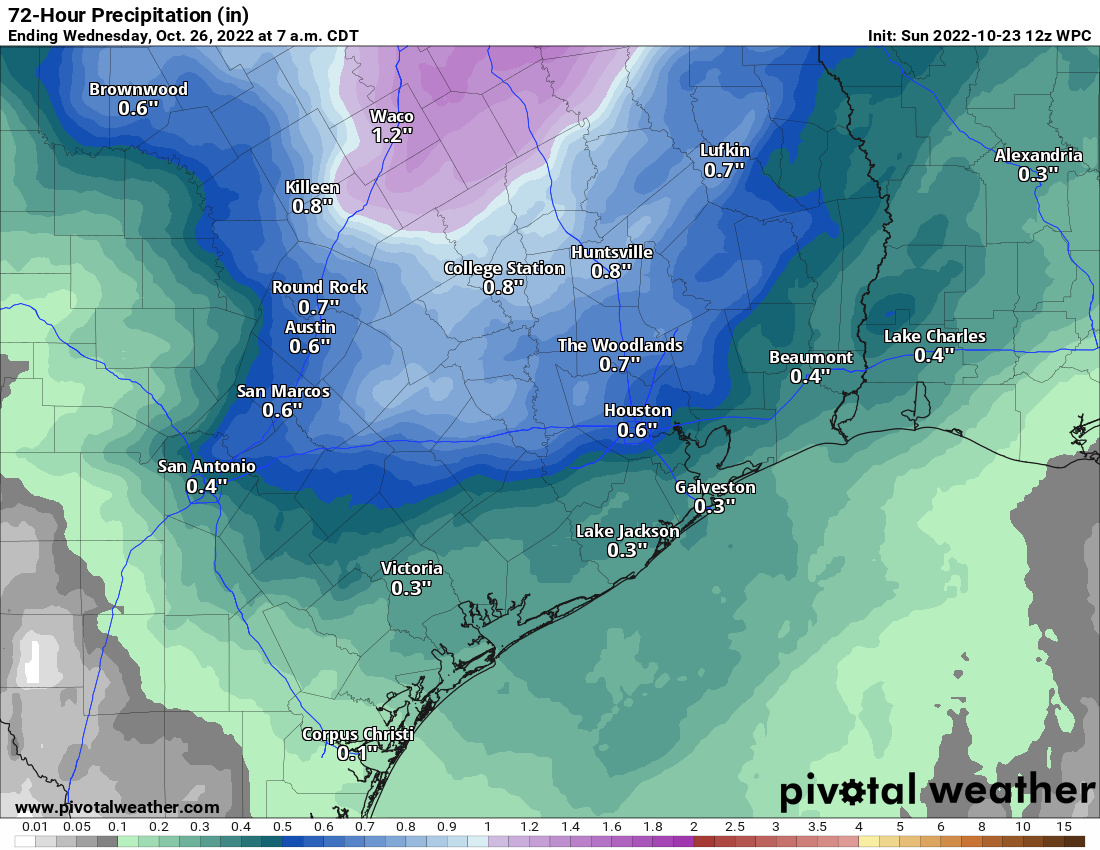
NOAA rain accumulation forecast for now through Thursday. (Weather Bell)

Thursday and Friday

The chance for heavy rainfall will linger toward the end of the week, but we’re going to see conditions favoring such activity start to decrease as the upper atmosphere becomes less supportive. I’d say about 50 percent of the area will see rain each day. Highs probably will return to about 90 degrees, with a mix of daytime clouds and sunshine.

Saturday, Sunday, and beyond

The weekend should see partly to mostly sunny skies, with highs of around 90 degrees. Some decent 30 to 40 percent rain chances will linger on Saturday and Sunday, but at this point accumulations looks slight, and any showers that do form should pass fairly quickly.

Overall, next week, the atmosphere looks to remain unsettled in the absence of high pressure. Look for high temperatures to continue in the neighborhood of 90 degrees, with daily rain chances of 50 percent, or perhaps even a bit higher. We have no significant flooding concerns at this time.

The state of Texas should remain in a fairly wet pattern for much of next week. (Pivotal Weather)

Tropics

The National Hurricane Center continues to track a wave in the Atlantic that is moving westward. However, this wave is encountering a lot of dry air, and development this week is unlikely. Aside from that, things look fairly quiet for several days. However, by next week it does look as though things will start to kick off a bit more. We’ll need to watch the Caribbean Sea for potential activity, as well as additional tropical waves moving off the coast of Africa. Nevertheless, for late August, this is a great place to be when it comes to the Atlantic tropics.

Tonight could be more active than anticipated, so we’re issuing a Stage 1 flood alert for the region’s northern half

Good evening. Just a quick update to say that we’re expecting shower and thunderstorm activity during the overnight hours to be more widespread than previously thought, and that this threat will persist into Tuesday. The greatest risk for heavy rainfall continues to be north of Interstate 10, so we’re issuing a Stage 1 flood alert for parts of the metro area along and north of this freeway. Areas south and west of Houston may also see some heavy rain, but the biggest threat appears to be further inland, to the north.

The problem is that a slow-moving boundary is sagging into the region from the northwest this evening, and it’s finding an environment fairly conducive for additional showers and thunderstorms tonight. In meteorology speak, we’re likely to see the convergence of boundaries that efficiently produce upward motion in the atmosphere. Given the overall tropical air mass, some storms could produce rainfall rates of 2 inches per hour, or higher, which will quickly back up streets. Some parts of the Houston metro area could see an additional 2 to 4 inches of rain overnight, into Tuesday morning, with higher isolated totals. The potential for heavy rainfall, again focused north of Interstate 10, will likely continue on Tuesday.

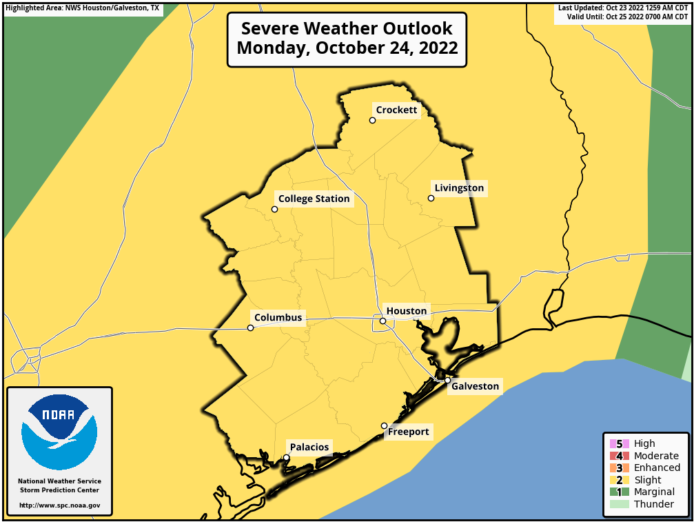
Locations favored for heavy rainfall on Tuesday. (NOAA)

Here’s the truth: We’re not entirely sure what will happen. We know the ingredients are there for heavy rainfall tonight. It could be a bust, or some location in San Jacinto County could pick up 6 or 8 inches. What we can say for sure is that the atmosphere has potential for heavy rains tonight, and we wanted to call your attention to it. We’ll be back with a full update in the morning.

Some parts of Texas are seeing too much drought relief

As Eric covered this morning, we’re watching rain chances here in the Houston area for the midweek period, as some rainfall rates may lead to street flooding in parts of the area, especially north of I-10. But we wanted to also catch you up on what’s happening elsewhere in Texas, as we know many of you travel to and fro or have friends and relatives across the Lone Star State. Here’s a quick rundown of what’s happened and what to expect.

DFW Metroplex flooded

Incredible amounts of rain fell on the Dallas and Fort Worth Metroplex overnight and into today, with some parts of Dallas and Tarrant Counties seeing 12 to 16 inches of rain in 24 hours. DFW Airport is approaching its single day rainfall record, and at worst it will finish as the second wettest day there on record.

Rain totals as of 1:30 PM local time in the City of Dallas ranged from a couple inches to as much as 15 inches or more east of downtown Dallas. (City of Dallas)

Many roadways are flooded, and if they aren’t, they are littered with flooded cars. Travel is discouraged to Dallas or Fort Worth the rest of today. Tomorrow seems like a better day for that, though you may encounter heavy rainfall between Houston and Dallas. So whatever your plans are, please use caution and budget in patience and pad.

City of Dallas rain total map
Tarrant County rain total map

Next round of flooding concerns

For folks in Dallas, the good news is that rain should ease up a lot this evening as the frontal boundary that has helped focus the rains has sagged south of the city. They will have a chance to clean up. Rainfall should begin to pick up in intensity a bit farther south though, and tonight’s focus could be Hill Country or the San Antonio and Austin areas.

In fact, Hill Country and parts of San Antonio, Austin, and Waco are being highlighted by the National Weather Service Weather Prediction Center (WPC) this afternoon for potential 2 to 3 inch hourly rainfall rates.

Rainfall rates in excess of 2 to 3 inches an hour may cause localized flash flooding in Hill County and close to the Austin, San Antonio, and Waco areas. (NOAA)

In addition to this, areas of northeast Texas may be targeted with heavy rainfall as well, and the flooding threat will extend to places like Texarkana and Tyler. Tyler is under a Flash Flood Warning as of this writing. Flood Watches include those locations, down to Lufkin and east past Shreveport, LA.

Flood Watches include all of Dallas, northeast Texas, northern Louisiana, and much of Hill Country. The main problems as of mid-afternoon Monday are between Fort Worth and Tyler. (Pivotal Weather)

Look for flood watches and warnings to shift through the week as the rainfall threat shifts.

Tuesday and Wednesday’s risks

Both Tuesday and Wednesday will see rain drop closer to Houston. We aren’t expecting the level of tremendous rain rates and flooding as seen in Dallas, but we’ll want to watch things closely over the next few days, as model precision in handling rain rates through these types of events is rather poor. As of now, the primary risk of flooding rains will extend from just northeast of San Antonio across northern parts of Houston into Louisiana tomorrow.

Risk of flash flooding will be highest on Tuesday from northeast of San Antonio across northern parts of the Houston metro, and especially for northern Louisiana, where a moderate risk (level 3/4) exists. (Pivotal Weather)

Then on Wednesday we’ll deal with residual rain chances in Houston and most flooding risks in Louisiana.

Will this end the drought?

Yes and no. Drought is complicated. The amount of rainfall needed to officially end the drought in Texas is 10 to 15 inches over a wide swath of the state. Other than the Dallas area, we aren’t seeing those kinds of totals over a wide enough area.

The amount of rain needed to “end” the drought in Texas was…a lot prior to this event. Some areas will get there. Many won’t. (Gregory Waller @wallywx92 on Twitter)

Drought is a little more complex than just needing a certain amount of rain, however. There are longer-term droughts, like the one Texas is in, which impacts agriculture, deep soil moisture, water supply, etc. Then there is short-term drought, which we also have had this summer. That leads to all of the above but also things like wildfire risk. This rain will absolutely help, if not end the short-term drought in much of eastern Texas. It will help the long-term drought as well, but we will need more rain in the coming weeks in order for that to be effective. I spoke a bit about this on Texas Standard this morning.

Why is this so bad so fast?

There’s a saying that droughts end in floods for a reason. Texas is a state of extremes, becoming further exacerbated in a warming climate. In this case, a persistent weather pattern that plagued us with drought and heat all summer finally flipped, simultaneous to a bunch of added moisture from the Southwest monsoon (which itself may have been energized somewhat by the old tropical disturbance that flooded parts of South Texas over a week ago), as well as added moisture from this weekend’s PTC 4 that went into Mexico. All of this hit a sagging cold front, and someone will get slammed in that instance.

In a timely turn of events, new research has come out showing how dry soil can exacerbate flooding issues with heavy rain. You can read about that here.

The bottom line: Texas has a history of droughts ending with floods. That’s sort of what’s happening here. While this may not necessarily be the “end” of drought for all of Texas, it will be for some of the state. Please use caution and stay aware of rain risks over the next few days as it all moves through.

A rainy week ahead for Houston, but also a cooler one for late August

Good morning. After scattered showers and thunderstorms this weekend, the potential for more organized storms returns to Houston this week, especially areas north of Interstate 10. Most of the region will see 1 to 4 inches of rain through Friday, although isolated areas beneath the heaviest storms could see 6 or more inches. Please note that we’re not looking at continuous rainfall this week, by any means. Monday, in particular, should see a fair bit of sun.

These rains, which will likely reach their maximum coverage on Wednesday, are due to a very moist atmosphere and a series of disturbances in the atmosphere. The overall pattern will support slow-moving storms, which is a concern due to the potential for high rainfall rates. At this time we’re not expecting significant or widespread flooding in the greater Houston area, however stronger and slow-moving storms will likely flood some roadways this week.

NOAA rain accumulation forecast for now through Friday. (Weather Bell)

Monday

Showers today will be fairly scattered in nature, and due to at least partly sunny skies I think we’ll see a warm day with high temperatures pushing into the mid-90s for much of the area. Rain chances are likely about 40 percent for much of the day. However, late this afternoon or evening we should see a line of storms moving through our northern areas, such as Montgomery and Walker counties, in association with a boundary. This line of storms should steadily weaken, before (probably) dying around around Interstate 10. Things should quiet down overnight.

Tuesday

The potential for more widespread rainfall increases on Tuesday, with coverage of 50 to 60 percent of the area. Chances will be highest north of Interstate 10, in places such as Montgomery County. With more clouds, expect highs to peak around 90 degrees.

Areas most favored for heavy rainfall on Tuesday. (NOAA)

Wednesday

This is the day we expect the most widespread rain in the metro area, with chances of around 80 percent. We still don’t have great confidence in the timing of storms on Wednesday, but should be able to offer some better guidance in tomorrow’s post. Highs for most of the area should remain in the upper 80s.

Areas most favored for heavy rainfall on Wednesday. (NOAA)

Thursday and Friday

As the atmosphere starts to dry out some, rain chances should fall back to around 50 percent or so to end the work week. Look for highs of around 90 degrees, with partly sunny skies.

Saturday, Sunday, and beyond

I think the pattern will revert to more typical conditions for late summer this weekend, with partly to possibly mostly sunny skies, and highs climbing back into the low 90s. Rain chances are not zero, but likely will not be higher than 30 percent, or so, and will be driven by the afternoon sea breeze. If you were expecting us to fall into a high-pressure dominated hot weather pattern next week, don’t. All indications are we’re going to see healthy rain chances through the end of the month, with moderate highs in the low 90s.

Tropics

We are now officially in the heart of hurricane season for Texas, and the entire Atlantic basin. For us, this period runs for about the next six weeks, when the state is most vulnerable to hurricanes, and the Gulf of Mexico at its warmest to support them. So far, it has been a quiet year in terms of Accumulated Cyclone Energy, a measurement of the duration and intensity of tropical systems. The Atlantic basin has seen just 13 percent of its average cyclone energy through this week, according to hurricane scientist Brian McNoldy.

Accumulated cyclone energy is well below normal in 2022, so far. (Brian McNoldy)

The tropics are waking up, however. A tropical wave that recently moved off of Africa has a chance of developing this week as it traverses the Atlantic, although it will have to combat a fair amount of dry air over the next several days so it may dissipate. Behind this wave there are more, so we should expect to see activity continue to tick up. But the good news is that the season is slower than anticipated so far, and there’s no reason to think any of these systems are going to track near the Gulf of Mexico any time soon.