Heavy rains overnight, but radar clearing for morning commute

A round of thunderstorms moved through Houston during the overnight hours, dropping as much as 2 inches of rainfall for some areas pretty quickly, but now the Houston region is seeing a break that should hold through at least sunrise and probably the morning commute.

Wednesday

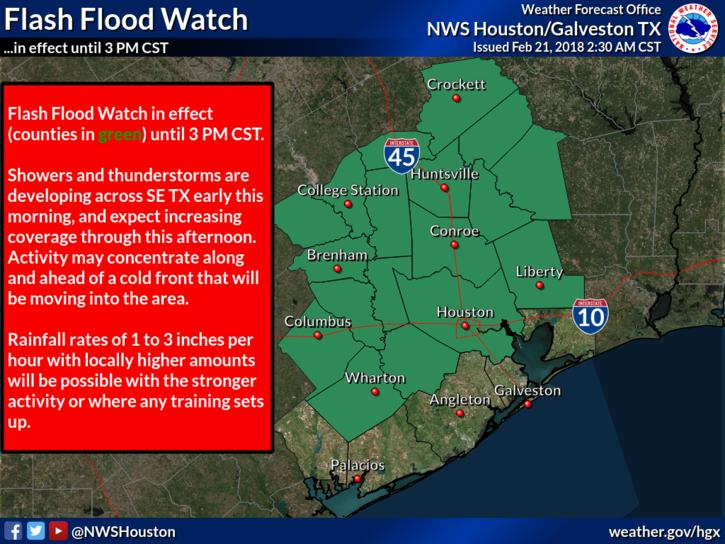
The cold front that’s helping to drive these showers (along with some kinks in the atmosphere moving northward into the region) isn’t going away, so there’s the potential for redevelopment of heavy rain later this morning and throughout the day. To that end, the National Weather Service has issued a Flash Flood Watch through 3pm this afternoon for most of the region, excepting the coast.

A flash flood watch is in effect until 3pm CT. (National Weather Service)

With that said, I don’t things will get too bad today, and probably at most we are looking at the potential for some short-lived street flooding during heavier downpours. Bottom line—check the radar before heading out for any trips beyond the local grocery store. The front should eventually make its way through most of Houston, leading to a somewhat cooler night in the 50s for most of the area except for probably along the coast.

See full post

Houston forecast turns wet, but how wet?

Conditions favorable for heavy rainfall will set up over Texas beginning later today, but for now we continue to think that the hardest hit areas will be north of Houston over the next two days. Regardless, we’ll be watching the system closely because of its potential for mischief.

Tuesday

After a warm morning, conditions will remain muggy throughout the day, with highs in the upper 70s and mostly cloudy skies. Winds will be gusty out of the south, and we may see some scattered rain showers this afternoon—but nothing to get too concerned about. We’ll have to wait until the overnight hours for heavier stuff.

Tuesday night, Wednesday, and Wednesday night

The combination of a very slow moving cold front (moving in from the northwest), very moist air, and a series of atmospheric disturbances moving north from Mexico will create conditions for bands of very heavy rainfall across Texas. As the map below from NOAA shows, the best chance for heavy rainfall appears to be north of the Houston metro area.

Seven-day rainfall accumulation forecast from NOAA. (Pivotal Weather)

As always, with these forecasts, they are a guide about general conditions rather than an exact prediction. Given the atmospheric conditions, we definitely will have the potential for heavy rainfall in Houston, too.

See full post

Spring arrives in Houston to stay—along with lots of showers

Houston had three consecutive days of 80-degree temperatures at the end of last week—the first time that has happened since mid-November. These warmer temperatures, generally in the upper 70s to 80 degrees are going to hang around this week, too. The other big story will be rainfall, with a couple of inches likely this week as moisture levels surge upward.

Monday

Today should be pretty nice, all things considered, and may be the best day of the week. We should see partly sunny skies, with only a slight chance of rain as high temperatures rise to about 80 degrees. The only concern is building southerly winds, which could make for a fairly gusty afternoon. These winds, and the moisture they bring, will be a harbinger for the rest of the week.

Tuesday and Wednesday

The primary dynamic beginning Tuesday will be increasing rain chances as a series of disturbances move into Texas from Mexico at the same time a slowly moving cold front moves toward the area and stalls. For now it appears the best rain chances will be north and northeast of Houston (certainly some flooding is possible for the areas facing 6 inches or more in the map below).

NOAA rainfall accumulation forecast for now through Sunday. (Pivotal Weather)

Rain chances appear to be highest from Tuesday night through Wednesday night, and I’d expect most of the Houston region to receive 1.5 to 2.5 inches, with higher amounts where heavy storms establish themselves. We’ll have to watch for the potential of street flooding. High temperatures will be in the upper 70s with warm nights.

See full post

Houston should turn cooler today

Many of our complaints about lack of sunshine were lodged and received. We’ve had a couple nice, albeit steamy afternoons this week, officially hitting 80 and 81 degrees on back to back days for the first time since November 17-18 of last autumn. For some that may be too much, too fast, but alas, here we are.

Today through Tonight

We’ll attempt to make another run toward 80 today, but added cloud cover and a few shower chances should limit how warm we can get. But, after a mild start this morning, we should still easily make the upper 70s this afternoon. There’s not much happening in the atmosphere to favor any significant showers today, but some lighter showers will be possible later as our next cold front approaches.

The front should make it to the northwest suburbs of Houston around 3-6 PM or so. Behind it, temperatures will ease back into the 60s and humidity should lower some. As the front moves through Houston, it will begin to grind to a halt. As of now, it looks like forward progress stops somewhere around Clear Lake to Dickinson. You can see this clearly while looking at an animation of dewpoints today.

NAM model dewpoints show how the front slams on the brakes southeast of Houston tonight. (Weather Bell)

So most of us will cool down into the mid or upper 50s tonight, but it will stay mild and humid southeast of the front, including Galveston east to Beaumont, where you probably won’t drop below 60-65 degrees. We’ll have low clouds and light showers behind the front and low clouds, drizzle, and fog probably ahead of it tonight. Fog may continue to linger in Galveston through the night.

See full post