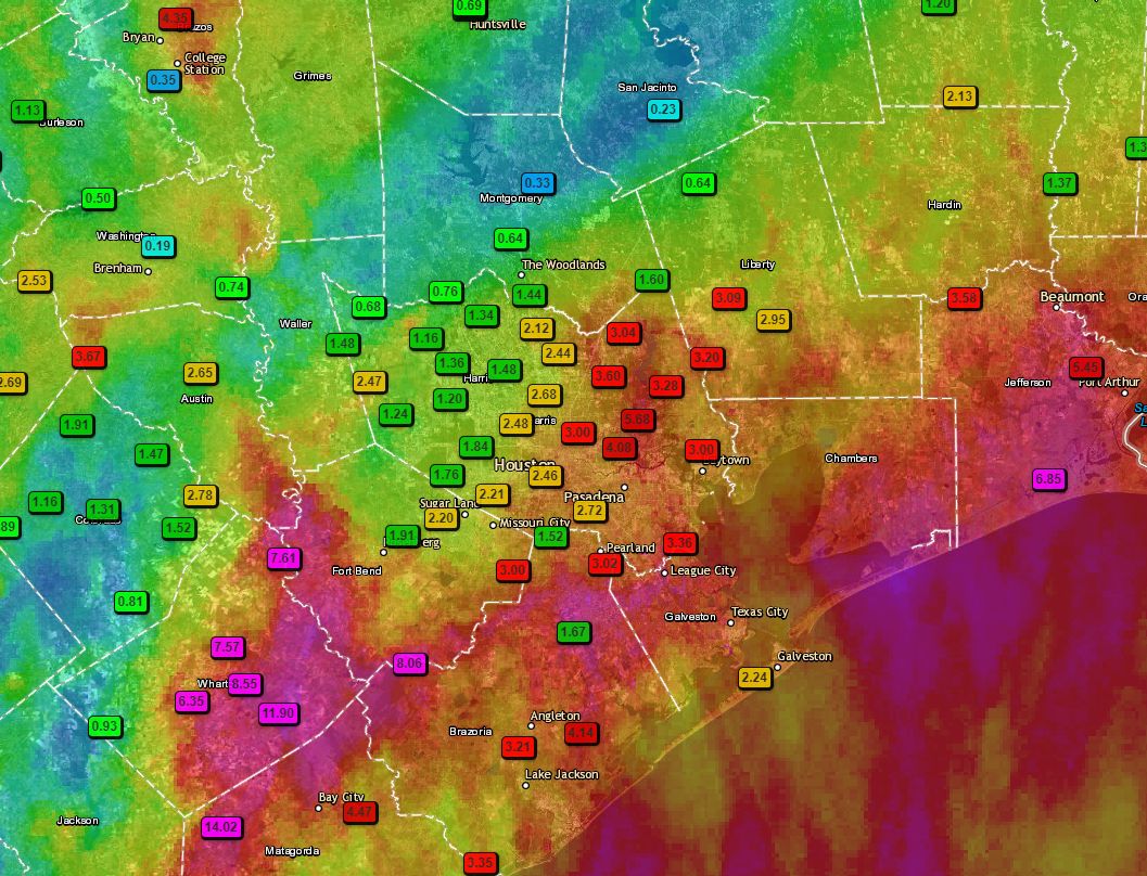
It’s been long day of storms for parts of the metro area—fortunately for Houston pretty much everything has now moved east toward Beaumont and Port Arthur, or (better) southeast into the Gulf of Mexico. Houston should (mostly) have a quiet night as storms fire to the east. Before getting to the forecast for the next few days, I wanted to share the following map of rainfall totals during the last 24 hours. It neatly illustrates the challenges of forecasting tropical precipitation along the upper Texas coast.
24-hour rainfall totals through 5pm CT Wednesday. (Texas Mesonet)
A few notes: We actually pinpointed the Matagorda region as a potential hotspot during the overnight hours, and they along with Wharton County certainly bore the brunt of heavy rainfall with 14+ inches in a few locations. An area near College Station also picked up 5 inches of rain, as did Port Arthur. Closer to Houston, the eastern half of Harris County got the worst of it on Wednesday. I would also like to point out that fewer than 100 miles separates Wharton, where a foot of rain fell, from Conroe, where one-third of an inch fell. Welcome to meteorology.
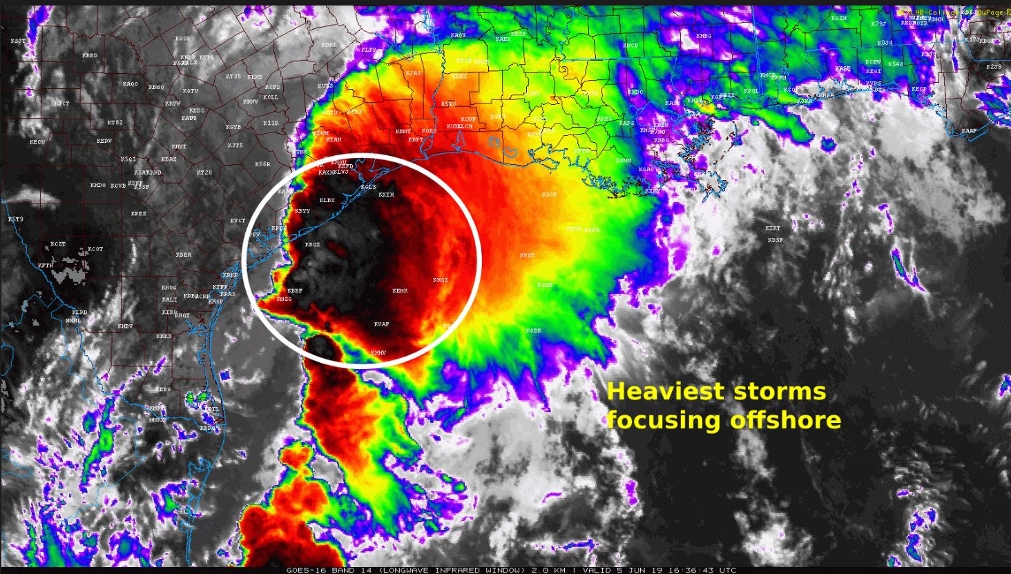
Over the last couple of hours, the radar has shown the heaviest rainfall congealing offshore, and this seems to be in response to falling pressures as the tropical disturbance moves north across the Gulf of Mexico. The net effect of this is that the offshore storms are robbing inland storms of moisture, and thus sapping their ability to produce really high rainfall rates like we saw earlier this morning near Wharton. This is good news for the rest of today, although we’re still going to see some scattered storms, and areas immediately along the coast, such as Galveston, may see intermittent heavy rainfall this afternoon.
Radar image at 11:30am CT shows offshore storms strengthening. (NOAA)
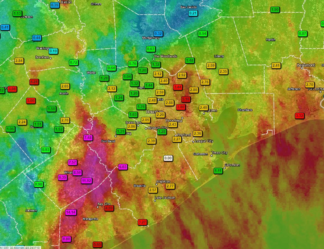
Most of the region has seen manageable rains today, and rainfall rates below 2 inches per hour. But we definitely saw the bullseyes we feared develop in Wharton, Fort Bend, and Matagorda counties this morning. One gauge north of Palacios recorded 14+ inches of rain, and a pretty large region saw 6+ inches since midnight. These totals are shown below.
24-hour rainfall totals for the Houston region. (Texas Mesonet)
The forecast for Wednesday evening through Friday remains tricky. Our best guess is that storms begin to redevelop onshore tonight, but the favored area is probably just east of Houston through the Beaumont area, and into southwestern Louisiana. In Houston, on Thursday, we will probably see less coverage than Wednesday—perhaps quite a bit less. We still have some concerns about later Thursday night and Friday, and we’ll address those in posts to come. My sense, however, is that the worst of this system, in terms of organized activity, is now slowly moving away from the metro area.
A large mass of storms continues to work through the Houston metro area this morning, but the rains have been manageable for the most part, with accumulations of 1-2 inches. However, we do have some significant concerns about areas to the southwest of Houston.
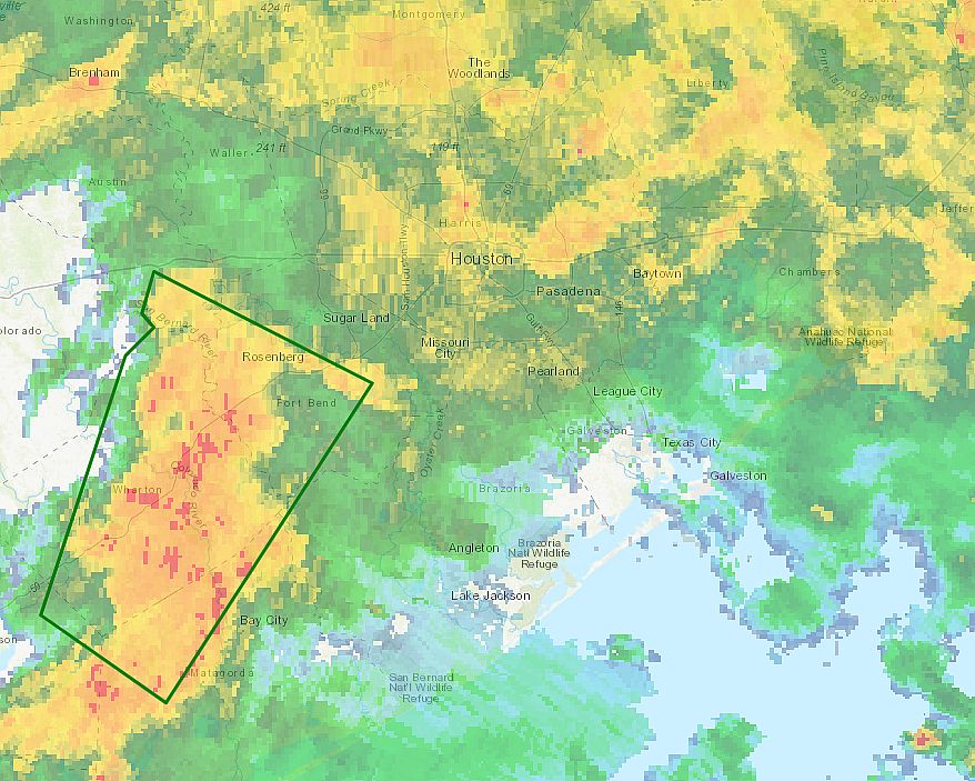
A particularly strong band of showers has established itself in Wharton and Fort Bend counties this morning. One location on the Colorado River, south of Wharton, briefly recorded rainfall rates in excess of 4 inches per hour, and has measured nearly 10 inches of rainfall since shortly before sunrise. A flash flood warning is in effect for this area through 9:45 a.m., and we anticipate these storms will slowly move east, toward Brazoria, southern Harris, and Galveston counties this morning. So if you live in the southern half of the metro area, pay close attention to the radar for the next several hours.
Area of flash flood warning in effect until 9:45am CT. (National Weather Service)
Most of the high-resolution modeling suggests this very moist air mass will shift mostly offshore by this afternoon, perhaps by around 2pm to 4pm. This should then lead to a reprieve in widespread storms at least through this evening.
The forecast for Thursday and Friday is not particularly clear, but we do not expect quite the organized storms that we are seeing across much of the Houston metro area this morning to persist. Nevertheless, heavy rain will remain a threat heading into the weekend. We will try to firm up this forecast in a new post later today.
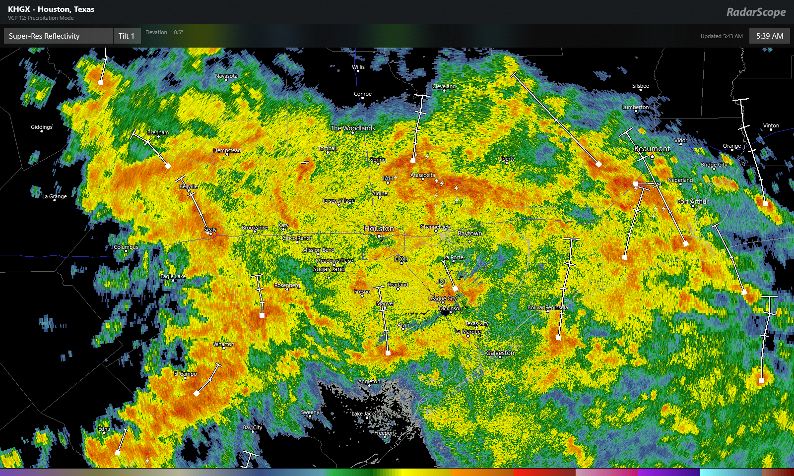
We got through most of last night without any issues in Houston. Storms lined up well southwest of Houston near Matagorda Bay after midnight and have arrived across most of the metro area early this morning.
Radar at 5:40 AM shows widespread moderate to heavy rainfall across the Houston area. All this is moving slowly north and east and will be with us most of the morning. (RadarScope)
Radar as of 5:40 AM shows moderate to heavy rainfall across most of the area (with the exception of Freeport and north of The Woodlands). But everyone should see at least some rain through the morning.
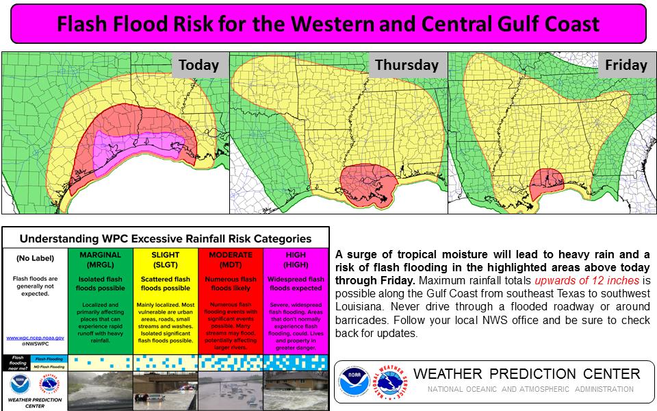
As the day progresses, this rain will taper off or become more scattered in nature generally north and west of US-59/I-69. But heavy rain should continue into this afternoon generally south and east of there. A Flash Flood Watch remains hoisted for most of the area. We also have most areas south and east of US-59 in a “high risk” for flash flooding from the Weather Prediction Center today.
The Weather Prediction Center arm of NOAA has issued a “high” risk for flash flooding today for the southeast part of the area. (WPC/NOAA)
The WPC doesn’t hand out high risks easily, so that speaks to this system’s potential. A quick reminder from us: Please use caution when out and about today. It would be good to limit travel when you can on days like this, but if you are commuting or have to be heading out somewhere, be very careful and never drive through flooded roadways.
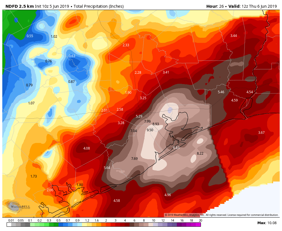
Total rainfall through this evening is expected to be on the order of 1 to 3 inches north and west of US-59. Some folks, particularly up in far northern regions (Conroe, Navasota, Cleveland to suggest a few) may see a bit less. The trouble spots are expected south and east of US-59. We expect 3 to 6 inches on average south and east of there, but some places will see higher amounts on the order of 6 to 10 inches or even a bit more.
Through this evening, rainfall amounts will average 1-3″ northwest of Houston and 3-6″ southeast of Houston, with higher amounts likely near the coast and bays. (NWS Houston via Weather Bell)
There are still some uncertainties with how this will exactly play out, but in general this will work for today as a forecast. This outcome would likely cause a good deal of street flooding in parts of southeast Harris, Galveston, Brazoria, and Chambers Counties. Bayou or creek flooding is also possible, especially along Clear Creek or perhaps some of the bayous in southeast Harris County.
The bottom line today: Flash flooding, particularly street flooding is likely in areas south and east of downtown Houston at times today, especially through early afternoon. Some more serious street or even creek and bayou flooding is also possible in a few places, depending on exactly how much rain falls and how quickly it does. Rain should taper off a bit, or at least become more infrequent toward mid-afternoon.