The upcoming weekend will offer up a mixed bag of weather, featuring sun, clouds, some shower chances, and plenty of warmth and humidity. None of this should scare you away from whatever you were planning to do this weekend, though it will be warm! We still have a cold front in sight but not until midweek next week. That may possibly mean the end of “Second Summer” here in Texas.
Friday
We have another round of dense fog in spots this morning, particularly outside Grand Parkway. Places like Sugar Land, Katy, and areas west or south of there toward Wharton or Lake Jackson, as well as east of Houston in Liberty County and toward Beaumont are all seeing visibilities under a half mile as of 6:45 AM.
Visibilities aren’t terrible in the city this morning, but outlying areas are seeing a lot of dense fog, particularly well east and southwest of the city. (NOAA)
That fog will dissipate over the next 2 to 3 hours, and today looks fairly similar to yesterday. Expect a mix of clouds and sun and temperatures generally in the 80s. An few showers can’t be ruled out, but rain would be the exception, not the rule.
Saturday and Sunday
As Eric noted yesterday, both weekend days will carry a chance of showers or a thunderstorm. Expect any showers to be fairly short-lived and really not too big a deal. Based on today’s model data, I think Saturday may have a slightly higher overall chance for rain than Sunday. Outside of that, just a mix of sun and clouds with warm, humid conditions. Winds should be generally light on Saturday and then a bit gusty on Sunday. Expect highs in the 80s and lows in the upper-60s or 70s.
Monday and Tuesday
Look for rain chances to ease back a little here, as we end up with continued warm onshore flow ahead of a cold front that will stay to our north but an atmosphere without much to set storms off. Highs will be in the 80s and lows in the 70s. Winds may begin to pick up a bit again on Tuesday.
Midweek and beyond
The cold front we’ve been discussing is still on track to arrive on Wednesday. Models have been in disagreement on how robust the storm chances will be with this front, but suffice to say there will be at least a decent chance of thunderstorms on Wednesday. We should know more about this on Monday. Behind the front, look for refreshing air with lower humidity and gusty offshore winds. That should set up a very nice back half of next week.
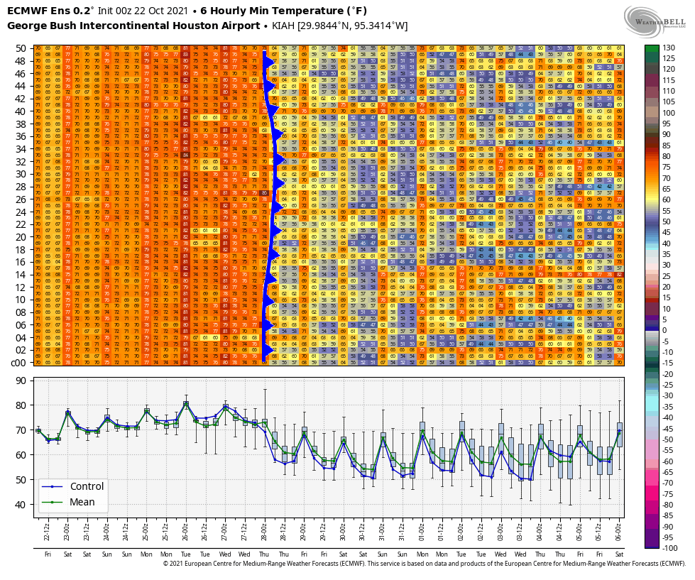
The European ensemble is consistent with a fairly strong cold front on Wednesday, but heading into next weekend and beyond there are enough mixed signals to suggest at least a more variable weather pattern may develop over Texas. (Weather Bell)
You can see from the chart above of European ensemble forecast low temperatures over the next 2 weeks that there is a rather mixed signal after next week’s front. Some ensemble members warm us back up, while others keep us cool. The overall weather pattern across North America may be shifting a bit to allow more frequent cold fronts into Texas. This should perhaps allow us to shift out of this “Second Summer” business and into true autumn. As Eric noted yesterday, the timing of this first front probably means a mild Halloween this year, but there is still ample uncertainty. Again, look for more on this on Monday. Have a great weekend!
It’s tough to argue with the stretch of weather we’ve had this week. It’s been warm, certainly, but with pleasant mornings and evenings and generally low humidity, it’s been pretty outstanding. We will have changes beginning this weekend, and those will set the stage for our weather next week.
Today & Saturday
Both days should be sunny and warm. Look for highs near 90° today with generally low humidity. A similar story unfolds tomorrow with perhaps just a few more fair-weather clouds dotting the sky. Morning lows will be in the 60s or low 70s again. The dewpoint, or how much moisture is in the air will be a couple ticks higher tomorrow, so you may notice it feels a bit more humid, especially in the morning. Patchy fog is also possible in the morning.
Two other quick notes: Air quality has been atrocious this week. The combination is two-fold: An inversion (temperatures warming as you go up in the atmosphere) has trapped pollution and smog near the surface in the morning hours leading to an ugly haze. That should continue today and perhaps tomorrow. Secondly: The full sunshine has led to high levels of ozone each day in the area. This isn’t as visible to the eye, but it can trigger some respiratory ailments in people. On top of all this, if you’re a seasonal allergy sufferer (raises hand), you’ve felt it this week. Ragweed is a big problem, as are mold spores. But, I mean, aside from that, it’s been great!
Sunday
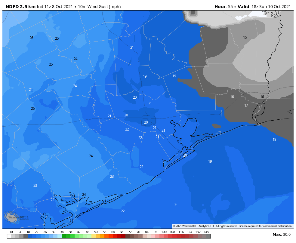
Our transition begins in earnest on Sunday. You’ll notice it a couple ways. First, expect sun and a few more clouds. Second, there could be a few light showers around, especially in the morning hours and especially southwest of Houston. The humidity will also be noticeably higher. In addition to all this, you’ll also notice the wind pick up Sunday. We’ve had a pretty lengthy stretch of light or calm winds this week, but onshore flow builds on Sunday with some 20 to 25 mph gusts possible, particularly near the coast. I don’t think this will be so much wind that it will impact Wings over Houston, but it’ll be a noticeable change.
While not particularly troublesome, wind gusts of 20 mph or so will be possible by Sunday afternoon, which is more wind than we’ve had all week. (Weather Bell)
Look for high temperatures on Sunday in the mid to upper-80s after morning lows in the 70s.
Monday
A cold front will take a swipe at the area on Monday, but it will likely come up short, fizzle, and/or quickly retreat back to the north. It will come close enough however to set off a few showers or storms Monday. We aren’t expecting anything too widespread, but some areas may see their first measurable rain in a good while. Look for warm and humid conditions with a continued onshore breeze. Expect mid to upper-80s after morning lows in the 70s.
Midweek
Tuesday through Thursday get a little more murky. The general expectation should be for warm, humid weather to continue. We’d likely see highs in the 80s and lows in the 70s. We would have at least a few showers in the area each day, but I am guessing the atmosphere will be fairly “capped” next week, meaning thunderstorm development would be tough to come by. That’s a typical Houston-area setup in autumn. Clouds and sun would take turns each day, aside from the isolated showers.
Late week
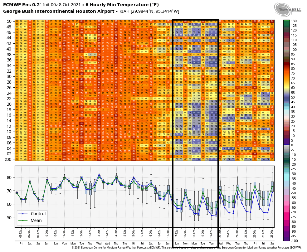
Here’s where the fun begins. When I wrote my post last Friday, I noted that there was no sign of a meaningful cold front for the foreseeable future. I cannot say that this week, however. Model support and evidence is building that a cold front, possibly a strong one, will push through the region sometime late next week or weekend. Over 90 percent of the Euro ensemble members (shown here) and over 50 percent of GFS ensemble members (not shown) have some sort of front pushing through next Saturday-ish.
Model support for a legitimate cold front is increasing for next weekend with lows in the 50s possible once again. (Weather Bell)
Of those Euro ensemble members, about 65% have lows in the mid-50s or cooler possible next Sunday or Monday the 18th. We will see if that can get us into our rhythm for the cool season here, which typically sees a front at least every week or so. Obviously, folks will be watching cold fronts with a little more urgency this year after February’s disaster. It’s still quite early, but we’ll be watching closely through the winter too.
Good morning. Depending on where you live this morning, it’s either quite stormy, raining gently, flash flooding, or doing not much at all. Most areas should see at least some rain this morning before all is said and done. Additional rain chances will continue through Sunday before a cool front ends this active pattern for us.
Today
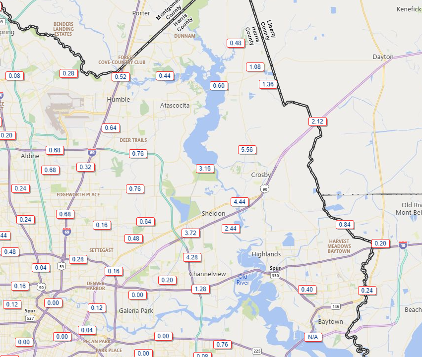
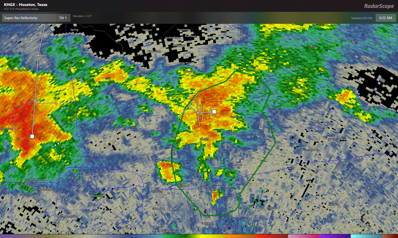
The eastern portion of Harris County has seen the bulk of the heaviest rain this morning, with areas north of Channelview through Crosby seeing 3 to 6 inches of rain so far, prompting a Flash Flood Warning through 9 AM for that area.
Rain totals in eastern Harris County have been significant and have likely caused flash flooding near Crosby, Sheldon, and generally north of Channelview. (Harris County Flood Control)
Over 2 inches of that 5.5″ near Crosby has fallen between 5:30 and 6:30 AM. At one point they had about 3 inches in an hour there. That will do it. Heavy rain continues in that Flash Flood warned area, but hopefully the pace slows over the next hour or so.
Heavy rain continues near Crosby but should hopefully be slowly exiting. Additional rain is possible in the flash flood warning area (green box) this morning, however. Click to enlarge. (RadarScope)
Zooming out, heavy rain is also lifting out of Spring Branch and impacting the northwest Beltway as of 6:35 this morning. Additional heavy rain was falling in the Katy and Fulshear areas and to the north in Hempstead and across Waller County. All of this is generally lifting north while redeveloping and easing to the east.
Rain continues to gradually advance east, so expect a soggy morning in much of the area, and where it hasn’t yet rained it very well may in the next few hours. (College of DuPage)
Expect periods of rain, heavy at times through the morning. Localized flash flooding like we see in eastern Harris County this morning can’t be entirely ruled out, so just use caution if you will be out and about through the morning. Rain probably should taper to scattered showers this afternoon. Temps will be held down due to the clouds and rain today, probably no better than the low-80s.
Saturday
Another round of showers and storms scattered over a fairly wide area seems likely tomorrow. If you are trying to make plans for outdoor events, it’s a bit tricky. The guidance I want to give you versus the guidance I can reasonably give you with the model data available are two very different things! Right now, it won’t be a washout it seems. So that’s good. As far as timing, my best guess is that we’ll see showers and storms developing closer to the coast in the morning, then spreading inland through the late morning and early afternoon, somewhat like what we experienced on Thursday. Not everyone sees rain, but those that do could see some fairly heavy rain for a short time. That said, this is very much subject to change, so no matter where or when your plans are tomorrow, at least have a backup option in mind if you get chased indoors by rain for an hour or two. Highs will be in the 80s after morning lows in the 70s.
Sunday into Monday
Alright, the end of this active pattern looks to begin on Sunday. There should still be showers and storms around on Sunday, driven in part by the front which will be dropping southeast through the day. Ahead of the front will see the best chance of rain, and this should include the Houston area through the coast. I don’t think the coverage on Sunday will be quite as significant as we see today and will see tomorrow, but as on those days, any rain could be locally heavy. Look for 80s, possibly mid to upper-80s on Sunday.
As far as the front goes, look for it to slog through the area. It should arrive in Houston on Sunday evening, then only slowly advance to the coast, hopefully clearing it by Monday morning. And I’m intentionally calling this a “cool” front because behind it, while we will have noticeably lower humidity, the temperatures won’t be much more than slightly cooler.
Tuesday and beyond
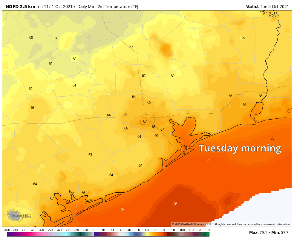
In fact, Tuesday morning should see pleasant lows in the 60s. Daytime highs, however, will be in the mid-80s at least. The humidity will be much lower though.
Tuesday should see very comfortable morning lows in the 60s everywhere away from the immediate coast, while daytime highs will remain rather hot with at least mid-80s expected. Humidity will be noticeably lower though. (Weather Bell)
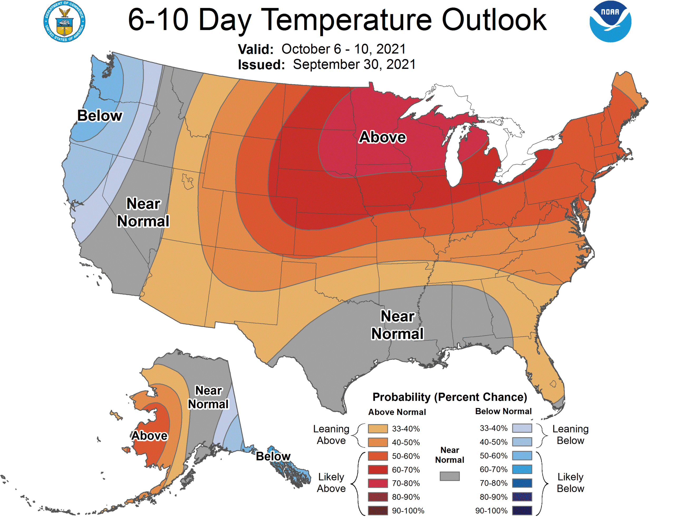
This relatively nicer weather should continue most of the week, with sun-filled skies, warm days, and pleasant evenings. The overall pattern across the U.S. is one that favors very warm weather in the northern part of the country, while we see temperatures maybe only a couple degrees above average.
A warmer north/normal south type setup should dominate the U.S. weather map next week. This should keep any *strong* cold fronts at bay for a bit. (NOAA)
This pattern is important for us here in Houston because it should limit the chances of any very strong cold fronts into Texas. In fact, when I look at most model data after next week, I see minimal chance for any sort of meaningful fronts through mid-month. That could change, obviously but sitting here today, I’m not optimistic we are going to see any legitimately cool weather here anytime soon.
Tropics
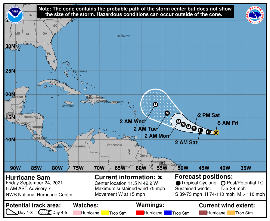
Hurricane Sam continues to rage in the open Atlantic, back up to a strong category 4 storm this morning, with winds of 150 mph. Sam has been really incredible to watch meteorologically, and thankfully avoiding all land masses, the best kind of hurricane.
Hurricane Sam is raging over the open ocean with 150 mph maximum sustained winds. (Tropical Tidbits)
Our official morning low at IAH Airport was 57° yesterday and 58° today, the coolest pair of back to back days since late April or early May. We are now on the “other side” of things in the wake of the cold front, which means that, while it will still be quite nice the next couple days, it will begin to warm up a bit.
Today & Saturday
Both days look mainly sunny with light winds and comfortable humidity. Look for highs in the mid-80s and nighttime lows inching back into the lower or middle 60s.
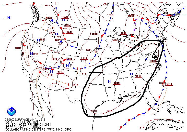
Sprawling high pressure dominates the eastern half of Texas and most of the southeast third of the U.S. this morning (NOAA)
As high pressure gradually slips to our east, we will see onshore winds gradually return here, which means humidity will inch back up just a bit also by tomorrow.
Sunday
The end of the weekend will mark the true transition back to more late-summer weather. Expect continued sunshine and a morning low in the mid-60s (warmer at the coast), followed back daytime highs in the mid to upper-80s with a bit more humidity.
Monday & Tuesday
Weather models had been pretty aggressive with bringing rain back to the area next week. For Monday and Tuesday at least, that doesn’t seem too likely. Yes, there will be shower chances on both days, but the setup initially looks kind of mediocre, with probably just a few showers and generally lighter rainfall totals by the end of Tuesday. We will see clouds and plenty of humidity though. Look for highs near 90 degrees and lows in the 70s.
Wednesday & Thursday
The middle to late part of the week may see just a little more support for showers, so rainfall could be a bit more noticeable then. Highs will be contingent on cloud cover and could exceed 90 with enough sunshine, but we’ll generally call for upper-80s or a little cooler with more rain showers.
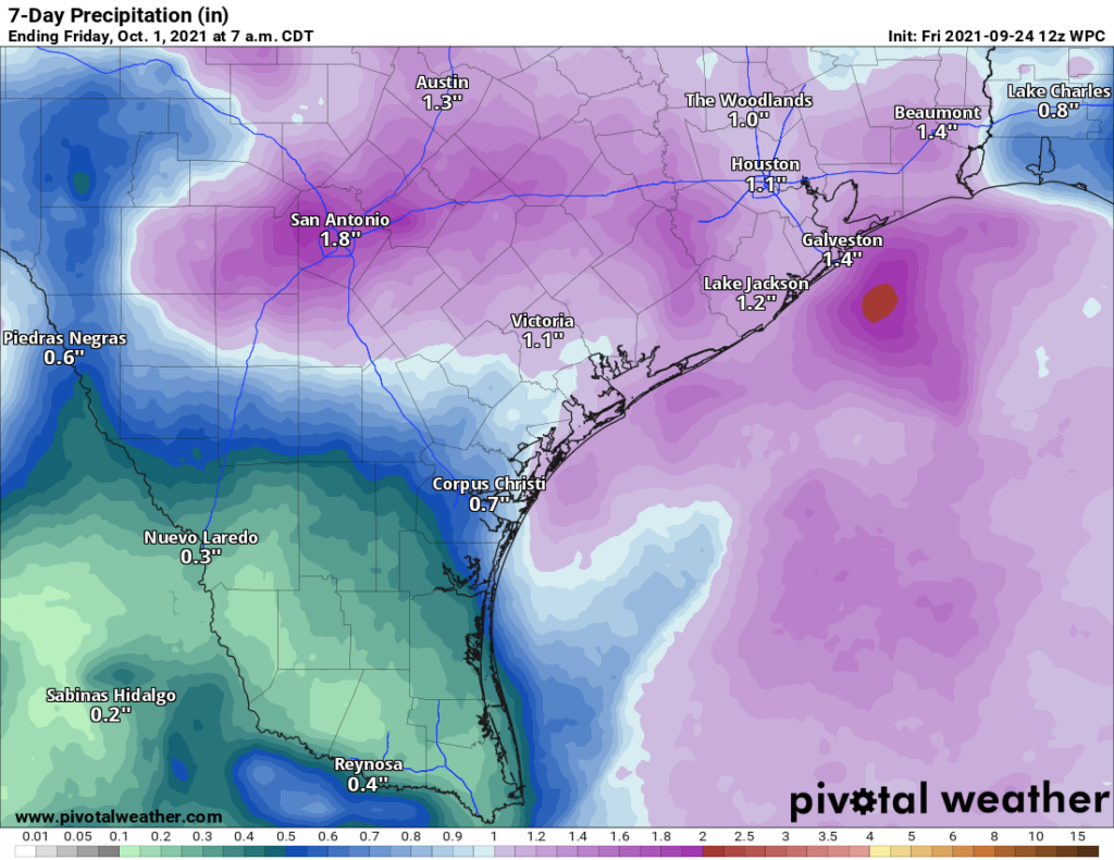
Generally about 1 to 2 inches is expected on average next week, with perhaps a lean toward the lower end of that range in the Houston area. (Pivotal Weather)
Overall, we aren’t especially excited about this setup for rain next week. Given the models maybe backing down some today, it looks like an average of 1 to 2 inches is most likely across the region. The highest amounts may be south and west of Houston. Some of you may see less than an inch too. More on this for you Monday.
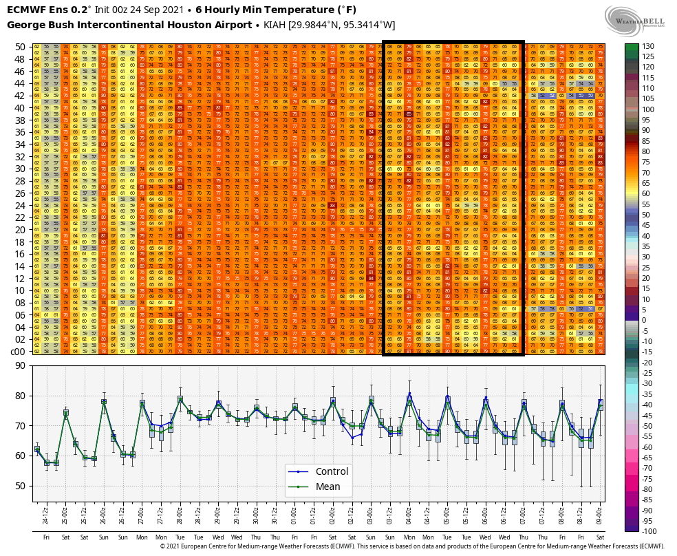
Late next week
Weather models have been at least hinting at some kind of cold frontal passage later next week for a few days now. It’s too early to get too specific, but I think the evidence points to a couple things right now. First, the “front” will probably not be like this week’s front in that we aren’t going to turn significantly cooler behind it but rather a little cooler but a good bit less humid. I wouldn’t expect 50s for lows right now, but we’ll see.
When you look at the 51 members of the European ensemble late next weekend, most imply some kind of cold front passing through, but none show a particularly significant front. (Weather Bell)
Second, the timing of the front would be probably next Saturday or Sunday, so most, if not all of next week looks humid. Could all this change? Certainly. We’ll see how things go over the next few days and report back to you next week on what’s happening. So, soak up the next day or two if you like autumn weather.
Tropics
I want to just append a quick note on the tropics today because yesterday morning we had Tropical Depression 18. This morning we have Hurricane Sam. Sam has rapidly intensified into a hurricane out in the open Atlantic.
Hurricane Sam will continue intensifying into a major hurricane over the next few days, which should also help keep it north of the Caribbean islands. (NOAA)
Sam is expected to become at least a strong Category 3 storm over the next few days which will also help it probably track a little more to the north than it appeared a couple days ago. This should hopefully bypass the Caribbean islands entirely and then turn north and out to sea, though Bermuda may need to keep an eye on Sam. Otherwise, as Eric noted yesterday, at least the Gulf should remain trouble-free.