Last week, when I looked at the forecast for Thanksgiving week, there was not a whole lot to be thankful for. We had the potential for heavy rainfall on some of the busiest travel days of the year, and overall the weather simply promised a cornucopia of “meh” conditions. I’m happy to report that the outlook for this week has brightened, and that we should see as much sunshine as showers.
On a completely unrelated note, we’re in the last week of our annual fundraiser. We’re selling t-shirts, sweatshirts, and umbrellas, as well as accepting donations to support the operation of this site. We’ve had a tremendous response so far; so thank you to everyone who has contributed.
Monday
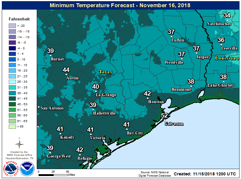
After a cold front slogged through the Houston region on Sunday, we’re seeing a chilly morning with temperatures ranging from about 40 degrees far inland to mid-50s along the upper Texas coast. Scattered showers have developed overnight, and these rains should continue on-and-off for much of this morning as upper-level winds support the upward movement of air at the surface.
Rains, for the most part, will be moderate, with accumulations of only a few tenths of an inch. They should end by this afternoon as this system moves from west to east. Temperatures will hang around the mid-50s today as skies will remain gray even after the rain departs to the east.