Category four Harvey slowly approaches landfall near Rockport

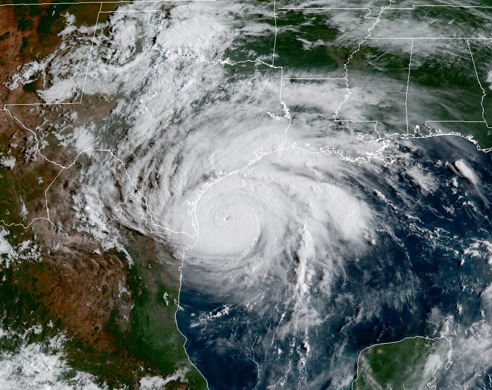
As of 7:45 PM Friday, Hurricane Harvey has been officially upgraded by the National Hurricane Center to a category four storm with 130 mph maximum sustained winds. Port Aransas just gusted to 105 mph as the eyewall approaches. Should Harvey make landfall at its current intensity, it will be the strongest storm (by wind) to hit Texas since 1961’s Hurricane Carla (which came ashore just north of where Harvey should) and the strongest in the U.S. (by wind) since Charley hit Southwest Florida in 2004.
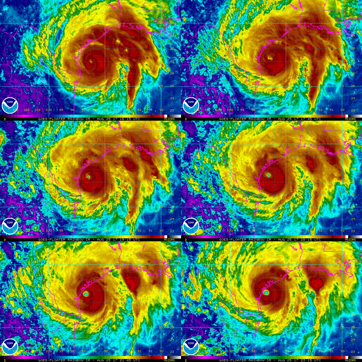
Haunting: Harvey strengthens to a Category 4 hurricane as it approaches landfall near Port Aransas and Rockport. (NOAA)


Coastal Texas from near Corpus Christi north to Matagorda are being absolutely pummeled by wind and squalls  and they will continue to deal with this in the hours ahead. Few words needed to describe the situation there, and our thoughts are with folks that live in that region.

Here in the Houston area, things are also active. We’ve had numerous tornado warnings issued throughout the day today, mainly south of US-59 and I-10. As these squalls and feeder bands on the north side of Harvey come ashore, they are capable of producing brief tornadoes, mainly in the coastal counties. These are extremely difficult to warn on because they spin up so quickly, and the NWS Houston office has done an outstanding job thus far with them. If you are placed under a tornado warning tonight, do take it seriously and seek shelter at your location (lowest level of the building in an interior room). Have a way to receive warnings overnight. A tornado watch remains posted until at least 2 AM for the Houston area, along and south of US-59 to I-10.

See full post

After looking at the latest forecast models, we feel pretty bad

Houston residents have started to see rain bands from Hurricane Harvey move onshore today. Unfortunately, this is but a taste of what awaits the city—and the entire Texas coast from south of Corpus Christi through the Beaumont area, as well as inland counties—for several days to come. I’d love nothing more than to write a post expressing some optimism about the rainfall forecast ahead, but as of now it looks really quite grim. So let’s get to it.

Harvey has intensified this afternoon, reaching 120-mph sustained winds and Category 3 status. It should come ashore the central Texas coast near Port Aransas on Saturday morning, by or before sunrise. The storm is going pack a major wallop in terms of both wind and storm surge. Residents in the area should have completed their preparations and evacuated, because conditions are starting to deteriorate. It is a life-threatening situation for people who have remained behind in low-lying areas between Corpus Christi and Matagorda.

Hurricane Harvey is coming. And unfortunately, he isn’t going anywhere. (NOAA)

Beyond Harvey’s landfall the situation remains a mess. An absolute mess. Last night we talked about three different scenarios for Harvey’s movement, post-landfall. And honestly, all three of them remain in play. The most important thing to understand is that our confidence in Harvey’s post-landfall track remains very low. Unfortunately the most likely scenario now is that Harvey isn’t going anywhere, any time soon. Therefore, we can say with high confidence that Harvey will produce a [googles a synonym for ‘sh–load’] large amount of rainfall over Texas.

Expect floods. Lots of flooding.

See full post

When inland flooding comes, rainfall rate is the key

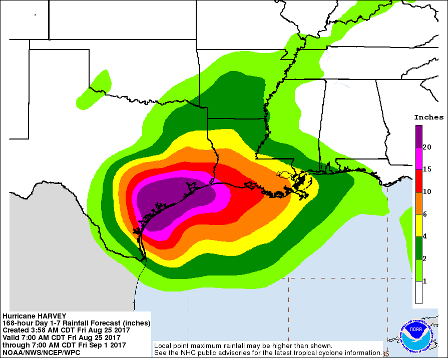
By now, we’ve all been inundated (pardon the pun) with model graphics such as the one Eric shared earlier this morning:

Rain accumulation forecast for now through Friday morning, Sept. 1. (NOAA)

As he mentioned, it is indeed a realistic portrayal of the rain our area could get over the next week. Twenty-plus inches of precipitation in such a short period of time is daunting, especially when you consider Houston averages around 50 inches a year.

We’ve had a number of questions about how the area’s bayous will manage the rain. Surely, they could handle four inches day, for five days, right? Unfortunately, for tropical systems like Hurricane Harvey, it isn’t the amount of rainfall that becomes a problem, as much as the rainfall rate. What is rainfall rate, and how will it and other factors influence how bad our flooding will be this week?

What is rainfall rate?

Rainfall rate describes how much rain falls over a period of time, and is measured in inches of rain per hour. A rainfall rate of 0.5″ per hour is considered heavy, while anything above 2.0″ per hour is intense. For context, Harris County experienced a maximum rate of 4.7″ per hour during the 2016 Tax Day Floods in a few isolated locations. It’s the difference between your sink faucet dripping for a week (a low rate), and your faucet breaking off for a half hour (a high rate). The same amount of water may come out of your pipes, but one will flood your kitchen much faster than the other.

Ditches and storm drains in Houston and Harris County can generally handle a rate of 1″ to 2″ per hour, for a few hours. Anything higher than that, over a longer period of time, leads to excessive runoff that can flood roads and fill the bayous faster than they can handle it.

See full post

Hurricane Harvey nears Texas, but may move back offshore

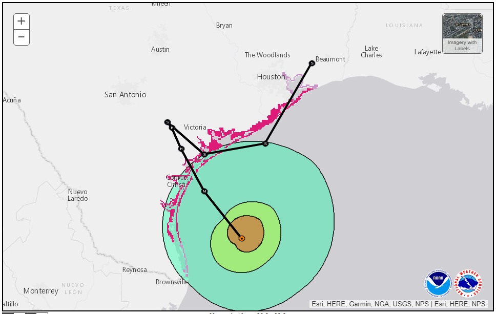
If you’ve read this site carefully over the last 24 hours, you’ll recall that I’ve been discussing a scenario I’m calling the “Euro special.” (See, for example, here and here). Under this scenario, Harvey makes landfall along the central Texas coast, dithers around for a day or two, and then moves eastward, back over the Gulf of Mexico. During its latest run the GFS model latched onto this scenario, bringing Harvey back into the Gulf, before the system eventually moves north-northeast toward Houston or Beaumont, getting drawn toward a trough of low pressure in the Midwestern United States.

As of their most recent update, the professional hurricane forecasters at the National Hurricane Center have bought into this scenario, with some caution. “At this time it is too early to say whether the center will definitely re-emerge over the northwestern Gulf of Mexico,” Robbie Berg wrote in the 10am discussion. Here’s the track they went with:

Zoomed track forecast for Harvey at 10am CT Friday. (National Hurricane Center)

Some thoughts

Such a track raises a number of unpleasant possibilities. In the interest of a free and frank discussion, you’ll have to indulge some speculation with this post. But this is a mature audience that seems to appreciate honesty. So here goes.

See full post