Your aunt’s turkey may be dry, but the Thanksgiving holiday won’t be

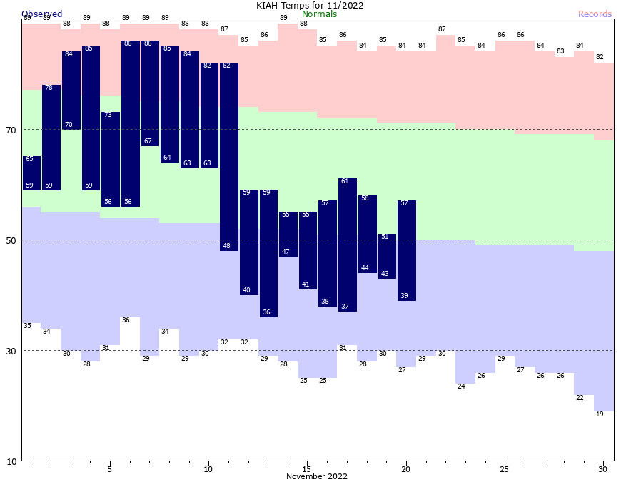
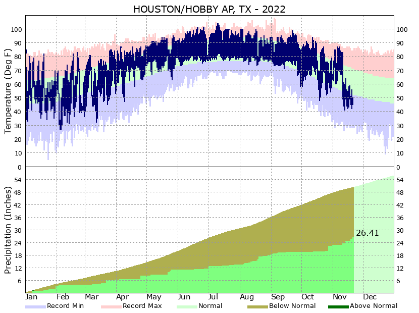
Good morning, Houston. I can’t say that I expected to wake up early this morning to the pitter patter of rainfall, but here we are. After a dry summer and early fall November has proven to be far wetter than anticipated. It has rained more than half of the days this month in Houston, although this has mostly been lighter rain. This wet pattern will persist through Thanksgiving, which I am afraid put a damper on outdoor activities—unless your family’s holiday rituals involve cyclocross or rugby.

With that said, it is difficult to complain too much about the rain. This month’s soaking rains are helping lift the upper Texas coast out of a drought that began this summer. Since we will experience another La Niña winter—which tends to bring drier and warmer conditions here—I was concerned about this drought persisting into next spring, or summer. A wet month won’t completely extinguish the region’s drought, but it is certainly very helpful.

Recent rains have helped cut into the drought at Houston Hobby Airport, a little bit. (National Weather Service)

Tuesday

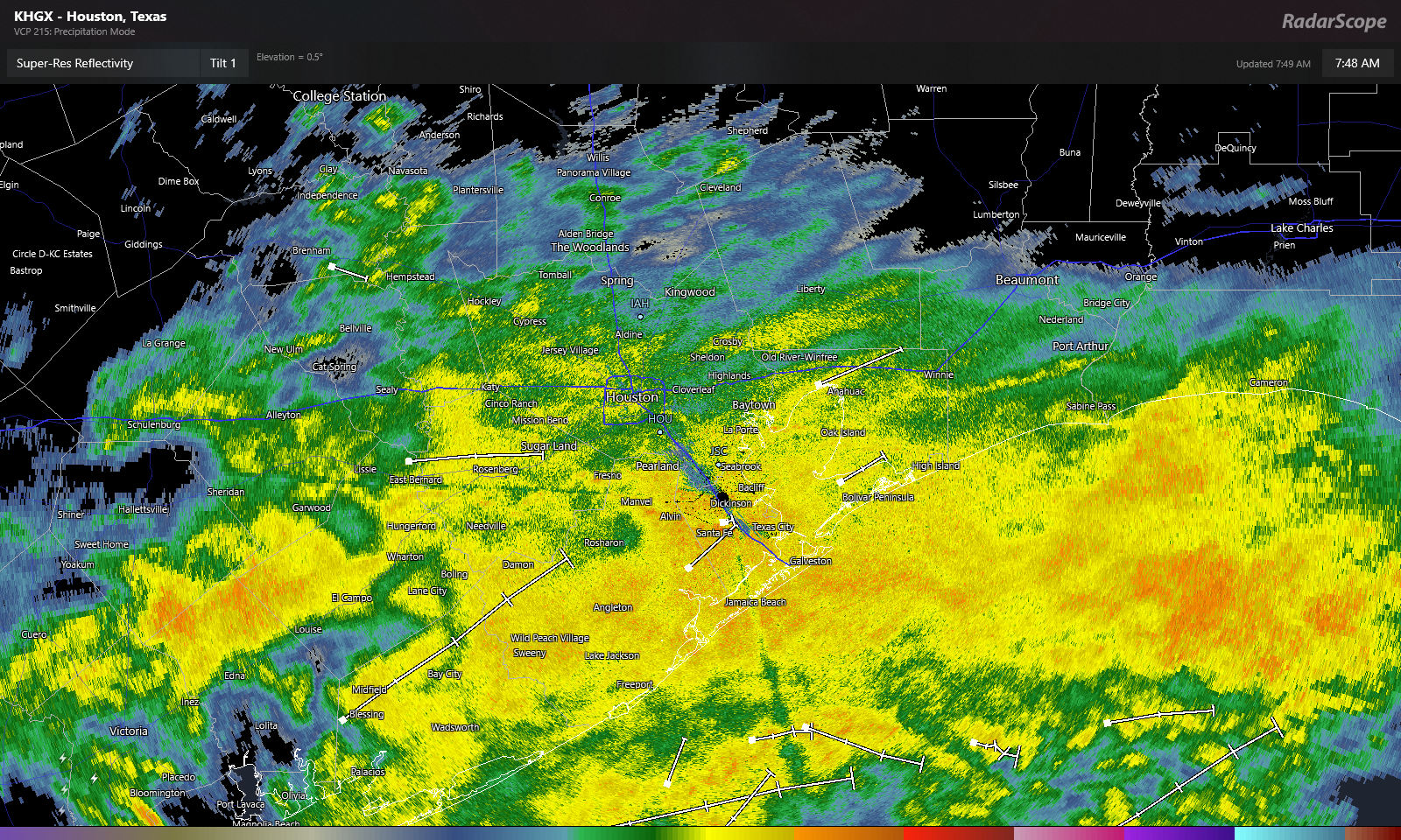
An atmospheric disturbance just offshore has hung around longer than expected this morning, somewhat like an unwanted house guest. This system is helping to produce ongoing light showers across much of the region south of Interstate 10. These showers may persist through the morning hours before finally dissipating. Inland areas may see a bit of sunshine this afternoon, but the coast is likely to remain mostly cloudy. Highs will range from the upper 50s to lower 60s. Winds will be light, out of the northeast. With mostly cloudy skies, low temperatures tonight probably will drop to around 50 degrees.

Wednesday

This should be a fairly nice day, as November days go. We’ll see partly sunny skies and highs generally in the upper 60s. Winds will veer to become more easterly, and this will start to increase atmospheric moisture levels, setting the stage for increasing rain chances Wednesday night and Thursday.

Thursday

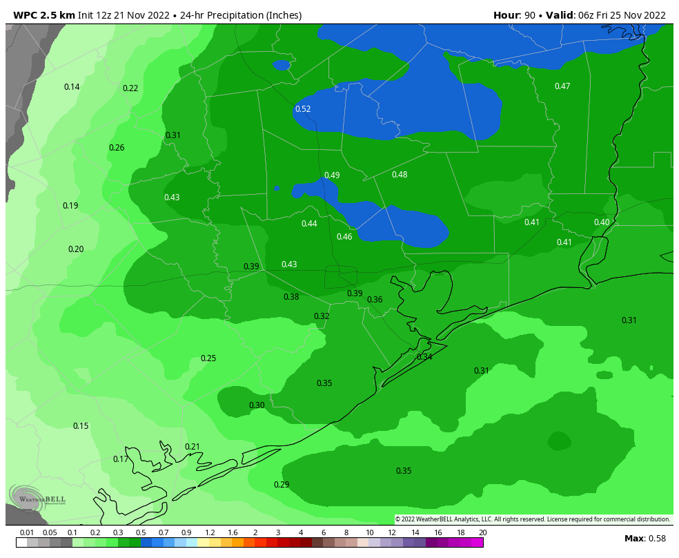
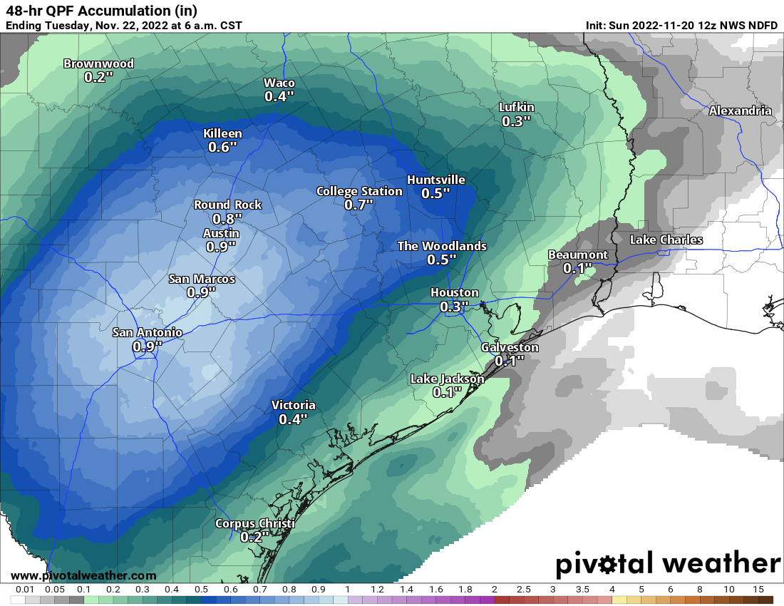
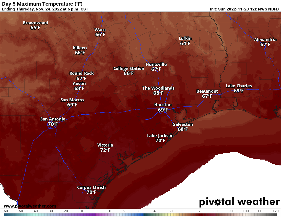
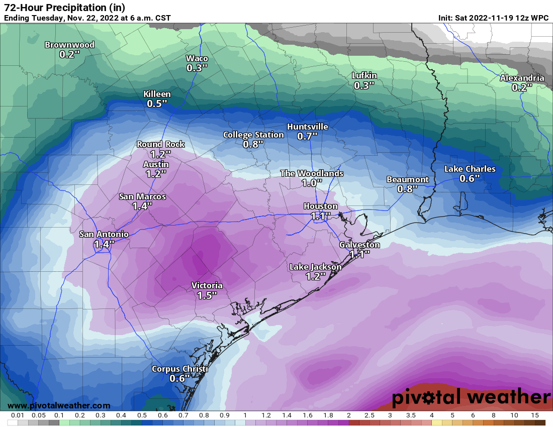
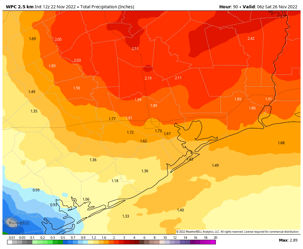
It looks like I’ll be able to eat turkey for Thanksgiving, rather than crow. That’s because, in our initial Thanksgiving outlook eight days ago, I wrote, “So my early forecast for Turkey Day calls for somewhat warmer, and possibly wetter weather.” This forecast is going to verify. Thanksgiving is going to feel fairly muggy for November, with highs in the low 70s and dewpoints to match. The timing for rainfall on Thanksgiving remains a bit uncertain, but there looks to be a healthy chance of light to moderate showers throughout much of the morning, afternoon, and evening. We can’t exclude some heavier rain showers, and these are most likely north of Interstate 10. All told, most of the area will likely see 1 to 2 inches of rainfall, with higher isolated totals.

NOAA rain accumulation forecast for now through Friday. (Weather Bell)

Friday

The rains will end at some point on Friday, but it’s difficult to say whether that will be midnight, mid-morning, or early afternoon—something to consider if Black Friday shopping is in your plans. As a front moves through, we will see some clearing skies, eventually. Expect Friday morning to start out in the 50s, with a high somehwere in the 60s.

Saturday and Sunday

This looks like a fine, late fall weekend with mostly sunny skies and highs in the 60s. Lows on Saturday and Sunday mornings will drop to around 50 degrees in Houston, with colder conditions inland, and slightly warmer ones along the coast. Rain chances are near zero.

Next week

We should see a warming trend for the first half of next week, with highs getting back up to around 70 degrees, with moderate nights. After Thanksgiving, the rest of November looks fairly dry.

Fundraiser

We’re in the final week of our fundraiser, the one time each year you have the opportunity to support what we do. Matt and I have lots of plans for 2023, so your help now allows us to put those plans into action. To support our efforts, you can buy Space City Weather merchandise here, or donate by clicking “I’d like to make a donantion” only. Thank you!

After 10 days in the icebox, Houston will thaw out like a turkey for Thanksgiving

Ten days ago a cold front blew into Houston, and since that time the region has experienced weather that is typical for the dead of winter, not late fall. The city’s warmest temperature during that timespan has been just 61 degrees, with lows in the 30s and 40s. Houston will face another chilly day or two before we start to warm up in time for Thanksgiving. Unfortunately that comes with a price: We’re increasingly confident of rainfall on the holiday.

Houston’s high and low temperatures this month. The green bar represents the normal range of highs and lows for the time of year. (National Weather Service)

Fundraiser

This is the final week of our annual fundraiser, and I want to genuinely thank everyone who has contributed so far. Matt and I work really, really hard on this site. Sure, some days there is almost nothing to talk about or forecast. But during inclement weather this is a full-time, full-tilt job. We plan our vacations around storms and weather—my family never vacations during August, for example. Our commitment to you is simple: We’ll be here when you need us. We’ll tell you when you need to worry about the weather, and we’ll tell you when you don’t. Our only goal is to be as accurate and transparent as possible. To support our efforts, you can buy Space City Weather merchandise here, or donate by clicking “I’d like to make a donantion” only.

Monday

If you like cold and dreary weather, then you’re having a banner November, and will enjoy more of the same today. Additional rainfall is inbound from the southwest this morning, as an upper level disturbance draws in moisture from the Gulf of Mexico. While this will make for a wet and gray day, I don’t think accumulations will be much over a quarter of an inch for most areas. Given the cold air and leaden skies, some areas may struggle to reach 50 degrees for a high temperature. Lows tonight will drop into the 40s.

Tuesday

High pressure will try to work its way southward on Tuesday, and this may help bring some breaks in the clouds. Some areas north of Interstate 10 might even see partly sunny skies during the afternoon hours. Look for highs of around 60 degrees, or perhaps a touch warmer where the sun breaks through for awhile. Lows Tuesday night will drop to around 50 degrees with cloudy skies.

Wednesday

Winds start to shift to come from the southeast, and this will herald the return of a warmer onshore flow. Look for highs in the mid-60s for much of Houston, with partly sunny skies. Lows on Wednesday night won’t drop too far into the 50s.

Thanksgiving Day

Alas, the forecast for the holiday is still a bit of a turkey, given ongoing uncertainty in the timing of the region’s next cold front. However the broad picture is pretty clear. The holiday should start out fairly warm in the morning, at around 60 degrees. Highs on Thanksgiving Day will push up to around 70 degrees. We are pretty confident that it’s going to rain at most locations in Houston on Thursday. The uncertainty comes in regard to timing and amounts, but generally expect better chances for areas inland of Highway 59/US 69 during the morning hours, and higher chances closer to the coast during the afternoon. As for accumulations, we might see anyhere from a few tenths of an inch to 1 to 2 inches. So yeah, if you’re having a big family gathering on the holiday, have a contingency for rain. Lows Thursday night generally should drop into the 50s.

NOAA rainfall accumulation forecast for Thanksgiving Day. This is very preliminary. (Weather Bell)

Friday, Saturday, and Sunday

In contrast to Thanksgiving, the rest of the holiday weekend looks fine and fall-like. Expect partly to mostly sunny skies from Friday through Sunday, with highs starting out in the low 60s on Friday and rising to around 70 by Sunday. Overnight lows should generally be in the 40s or lower 50s. Make your outdoor plans with confidence—and maybe a sweater for the evenings.

Houston dries out as we gain some clarity on holiday week weather

Yesterday didn’t disappoint from a forecast perspective. It pretty much went as expected. Rain totals ranged from around a half-inch to inch in Houston to around an inch and a half near the coast.

Estimated rainfall was highest south of Houston, with about a half-inch to inch across most of the metro area. (Pivotal Weather)

Your mileage may vary this morning, but the sun is out in force in my backyard, and it looks like many of us are enjoying a pleasant, albeit chilly morning! We will cling to this for a few hours before things begin to change. Again.

Fundraiser

We’re under 10 days left in our annual fundraiser, your one opportunity to directly support the site each year! The response has been amazing so far, and we are grateful to you all. You can click here to buy items. And if you don’t wish to purchase merchandise and just want make a contribution, click here and check the box that says “I’d like to make a donation only.” Thank you all so much!

Today and Monday

With many areas seeing sunshine this morning, it seems like it will be a nice front half of the day. As we go into the afternoon, clouds will begin to increase again. We are already seeing that creep into portions of Fort Bend, Wharton, and Brazoria Counties. Showers may begin to break out later today southwest of Houston. We should manage 50 to 55 or so this afternoon before temperatures are capped by increasing clouds. Areas southwest of Houston where clouds are already rolling in may not get above 50 degrees.

Rain will break out everywhere tonight. Periods of rain will be with us into much of Monday. The highest totals from this round may be north of Houston. That said, this rain looks as if it will be a little more sporadic in nature, so it may be truly “periods” of rain.

Rain totals tonight and Monday will average a half-inch or less in most spots. A few areas west of Houston may end up closer to three-quarters of an inch. (Pivotal Weather)

Rain showers should begin to taper off Monday evening and Tuesday morning.

Monday looks a lot like Saturday temperature-wise, with mid to upper-40s for most places at best.

Tuesday into the weekend

I think we’re beginning to get some decent clarity on this upcoming week. There are still questions about details regarding Thanksgiving itself, but our confidence is increasing for Wednesday and Friday.

Tuesday: Clouds, some sun, a shower possible. Morning lows 40s, daytime highs near 60.

Wednesday: Clouds, some sun, a passing shower possible. Morning lows upper-40s to near 50, daytime highs low or mid-60s.

Travel: We do not see any meaningful travel issues on Wednesday in Texas, Oklahoma, or Louisiana. Most major airport hubs look fine as well. Atlanta, Chicago, New York, DC, LA all look to be without major issues.

Thanksgiving Day: Clouds with a period of showers and storms possible. Exactly when & where is still TBD. Clearing late. Morning lows 50s, daytime highs upper-60s to near 70 degrees.

Thanksgiving Day looks warm — but not too warm. (Pivotal Weather)

Friday: Sunny! Breezy to windy, however. Morning lows 40s, daytime highs around 60 degrees.

Eric will have a full update on things for you Monday. Go Texans!

Rainy, raw Saturday with more coming Monday for Houston

Good Saturday morning to you! You don’t need to be an expert on meteorology to look at the below radar image from 7:45 Saturday morning to know it’s probably going to be raining for awhile.

Rain is going to continue through most of Saturday, with gradual improvement overnight. (RadarScope)

Rain will be with us all day today. We should see the rain become more intermittent or taper off after sunset tonight, but it may not clear out a ton before Sunday morning.

It’s in the 40s in most places in and around Houston this morning. Temperatures should refrain from budging much today, so expect the chill to remain.

Temperatures are mostly in the 40s this morning, and that is about as warm as they will get today. (NOAA)

In addition to the rain and the chill, it will be breezy today. Inland areas will experience 15 to 25 mph wind gusts today. Areas along the Gulf or bays may even see some 30 to 40 mph wind gusts. Coastal locations have wind advisories, gale warnings (offshore), and small craft advisories (bays) all posted for today and tonight.

Winds will add to the chill today. Look for inland gusts of 15 to 25 mph at most. Coastal areas and bays will gust north of 30 mph, with 40 mph gusts possible on the Gulf and offshore. (Pivotal Weather)

All in all, just a Southeast Texas winter type day today.

Sunday & Monday

Any lingering light rain or showers should taper off before sunrise Sunday. If we are lucky, we’ll be able to sneak in a few hours of sunshine tomorrow before clouds thicken back up. Showers could begin to break out again south and west of Houston by mid-afternoon. Those will overspread the area Sunday night and Monday before tapering off Monday night. Some of this rain could be just a little heavier at times than what we see today. Temperatures will be in the low-50s on Sunday, 40s Sunday night, and probably struggling to get to 50 on Monday.

When all is said and done, between Saturday and Tuesday AM we all should see roughly three-quarters of an inch of rain, with some places seeing an inch to inch and a half. (Pivotal Weather)

The farther north of Houston you are, the more likely you end up closer to a half-inch of rain. The farther south of Houston, the closer to an inch or more between today’s rain and Monday’s rain.

Tuesday through Friday

Some good news today: It appears that rain chances may be a little lower on Thursday. They certainly won’t be zero, and it seems likely that we see at least a period of rain at some point Wednesday night through Thursday. But it may be in a narrow window. Here is our updated thinking today:

Tuesday: Clouds, some sun, a shower possible. Morning lows 40s, daytime highs near 60.

Wednesday: Clouds, some sun, a passing shower possible. Morning lows upper-40s to near 50, daytime highs low-60s. (A note that travel conditions on Wednesday look decent across most of Texas and Louisiana)

Thanksgiving Day: Clouds with a period of showers and storms possible. Clearing late. Morning lows 50s, daytime highs upper-60s to near 70 degrees.

Friday: Sunny! Breezy to windy, however. Morning lows 40s, daytime highs around 60 degrees.

Fundraiser

Another thank you to all who have contributed to our annual fundraiser! It continues. You can click here to buy items. And if you don’t wish to purchase merchandise and just want make a contribution, click here and check the box that says “I’d like to make a donation only.” We are grateful for your support. Thank you!