Tuesday’s front moved through as advertised, dropping between 0.25 and 0.5 inch of rain across the area and pushing our temperatures down dramatically. After a gray day yesterday, expect mostly clear skies well into the weekend. Yes, we’re going to have yet another amazing fall weekend in Houston.
Wednesday
Conditions are generally cold, cloudy, and gusty this morning with low temperatures in the 40s. That will change as the cloud deck follows the front offshore, leading to clearing skies later today for the region. Partial sunshine should allow highs to reach the mid- to upper-50s—so quite chilly for the daytime—before another cold tonight with low temperatures falling into the mid-40s. Winds will die down today, coming from the north at 5 to 10 mph.
Expect another chill night for Wednesday night. (Pivotal Weather)
Thursday and Friday
These two smashing days will be partly to mostly sunny affairs, with highs in the mid-60s to 70 degrees and overnight lows around 50 degrees. The forecast models are somewhat split as to whether a modest cool front will push through on Friday to reinforce the cooler weather, but I think the biggest question is whether this drives low temperatures on Saturday morning down to the mid-40s, or lower 50s.
Good Tuesday morning, and welcome back to winter. Matt here, filling in for Eric today, and I bring you one of our grayest, chilliest days in a while. By my count, the last time we had a day anything like this was at least back on November 13th, when we stayed in the mid-40s most of the day with clouds and some occasional light rain. Today will carry that vibe.
Today
The front is through, and temperatures have plummeted since yesterday’s record high of 83° at both Hobby and Bush. In fact, we’re into the 50s this morning everywhere except for the immediate coast. Temperatures in the 40s are not far behind.
Temperatures as of 5:45 have fallen into the 50s everywhere except the coast, with 40s not far behind. (NOAA)
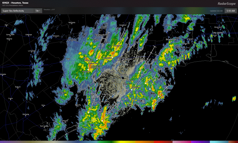
In addition to chilly temperatures, we’ve got some pockets of heavy rainfall around the area this morning.
A radar loop as of 5:50 this morning shows some heavy downpours north and west of downtown Houston, with more heavy downpours to the south moving into Brazoria County. (RadarScope)
The rain is moving fast enough and it’s been dry enough of late that there isn’t any flooding to worry about, but do be prepared to encounter some wet roads and puddles this morning.
Dress warmly today. Periods of rain and occasional downpours will be possible through about midday before we transition to more of a light rain or drizzle, ending in the afternoon. Temperatures will slowly drop from where they are this morning, into the 40s this afternoon. With a fresh breeze out of the north at 15 mph, gusting to 20-25 mph, it will feel even colder.
Tonight & Wednesday
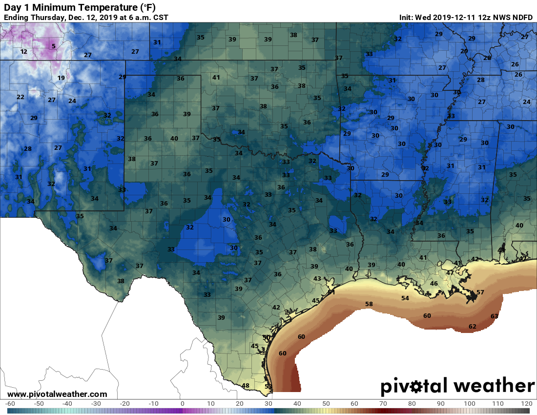
Low clouds should persist into tonight. The combination of lingering clouds and a little leftover wind should keep temperatures a bit above freezing for most areas outside. Look for Wednesday morning lows to bottom out near 40 in Houston, upper-30s in the surrounding suburbs mostly outside the Beltway, low-40s at the coast, and then mid-30s in farther outlying areas. I think even the Metro Houston icebox of Conroe will escape freezing temperatures tonight.
Overnight lows will be near 40° in Houston and colder in outlying areas north and west tonight into Wednesday morning. (Pivotal Weather)
Wednesday will be a fine late autumn slash early winter day. Expect any remaining low clouds to scour out and the sun to take over. Temperatures will warm into the mid- to upper-50s with much lighter winds than Tuesday.
Good morning. The basic forecast for this week calls for warm weather on Monday before a front sweeps through and keeps the region cool through Friday or Saturday. The notable thing about this front is that, tonight and Tuesday, it will bring our best chance of widespread rain in a month.
Monday
Temperatures on Monday will be quite warm, with highs near 80 degrees under mostly cloudy skies. A southwesterly flow will really pump warmth and moisture into the region, and at the surface we should see winds gusting up to 25 mph. The atmosphere generally will not support rain during the day, but that should change later on Monday night. But before the front arrives, we can expect a warm and humid night, with lows perhaps only dropping into the upper 60s.
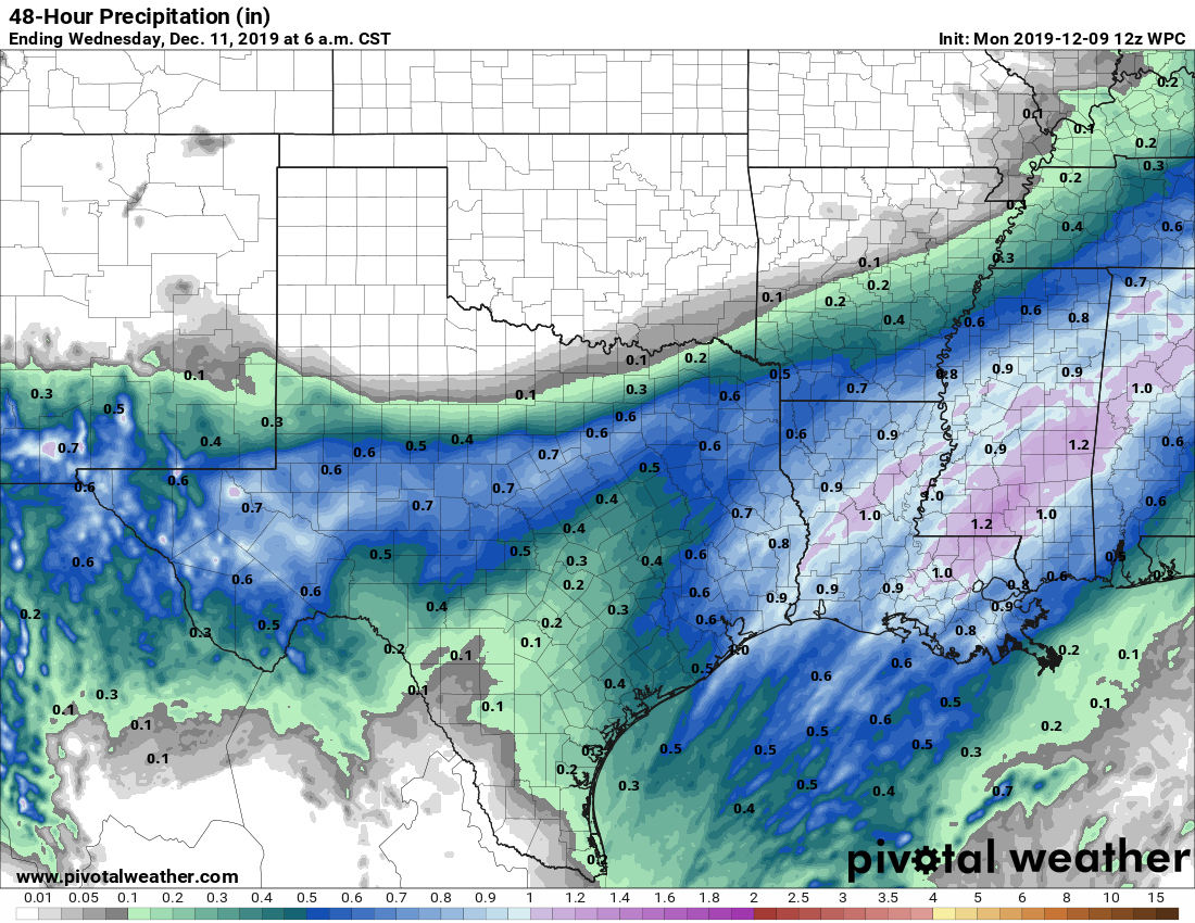
Rain accumulation forecast for now through Tuesday night. (Pivotal Weather)
Tuesday
The cold front should reach far northwestern Harris County by or shortly after midnight, and reach the coast roughly around sunrise. The temperature should drop 10 to 15 degrees in the wake of the front, and highs on Tuesday are likely to fall through the 50s throughout the day. Winds will be quite gusty, out of the north at up to perhaps 30 mph. The front won’t immediately scour moisture from the atmosphere, so we should be left with a gray, wet day—with on-and-off, mostly light to moderate rainfall. Right now, we expect that most people will probably receieve 0.25 to 0.75 inches of rainfall, with a few outliers either way. Rains should end by around sunset on Tuesday.
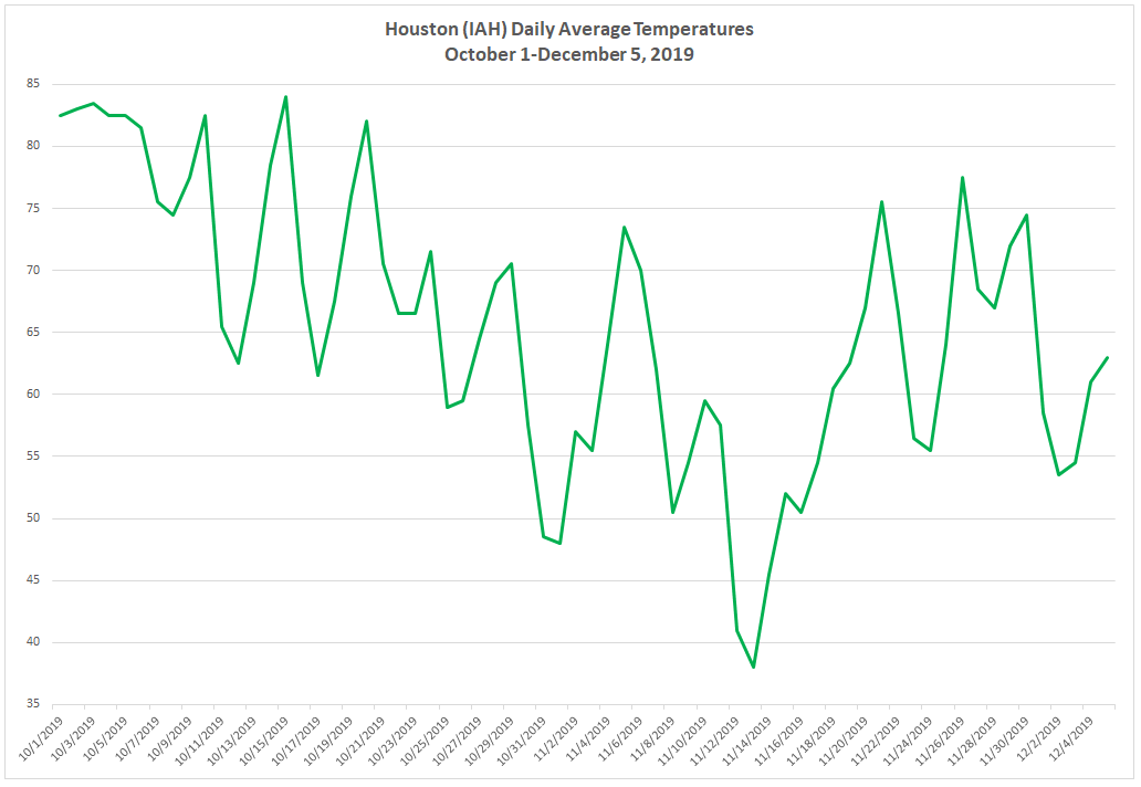
Quick shout out and thank you to Eric for covering me last Friday so I could go home to New Jersey and visit some family. It was cold up there. Had I still been living there, it would have been fine, but after 10 years in southern climes and this amazing autumn in Houston, my tolerance for anything under 40° is gone. This autumn really has been something, hasn’t it? Eric touched on the dry weather this fall yesterday. Let’s look briefly at daily average temperatures this autumn:
Daily average temperatures since October 1st at Bush Airport show an autumn with a lot of cold fronts to reinforce generally pleasant weather. (Space City Weather)
Each time the temperature dips on this chart, it basically indicates that we had a cold front. We’ve had at least 13 of them this autumn. And since mid-October, we have only seen a handful of days with daily average temperatures above 70 degrees. The key this autumn is that the pace of cold fronts has been frequent enough to keep onshore flow rather weak most of the time. So we haven’t had many really muggy days. It’s been virtual Goldilocks weather and one of the nicest seasons I have experienced anywhere that I have lived in my lifetime. And it will continue this weekend.
Today & tonight
Cold front number 14 (at least) of the season will cross through Houston today. We often show you where cold fronts are located based on temperature, humidity, or wind direction change. Today, it’s actually easiest to see the front’s location based on visibility. Ahead of the front, patchy dense fog has developed, especially southwest of Houston or near the water. But you can see roughly where the front is located really well based on where 10 mile visibility shows up.
As of 5:30 AM, you can see the general location of the front based on where visibility improves to 10 miles north and west of Houston. As the front moves through, low clouds and fog will scour out this morning. (NOAA)
The timing of the frontal passage now looks to be between roughly 9 and 11 AM from northwest to southeast across the area. There should not be a big temperature drop behind the front, but you’ll notice that any low clouds and fog will be quickly scoured out. The wind will shift and humidity will begin dropping as well.
Skies will full of sunshine this afternoon. Another winner. We will peak in the 70s later today. Drier air behind the front will allow for a cooler night tonight, with nothing worse than a few passing high clouds. Look for lows to drop back into the low-50s, with perhaps 40s in outlying areas.
Weekend
Saturday should see sunshine and a few passing high clouds. Sunday will see some patchy morning fog, then sunshine and some building clouds. Saturday should top off in the mid- to upper-60s, Saturday night will be back in the 50s, and Sunday will be a little warmer with high temperatures in the low-70s. North winds tonight of 10-20 mph will back off Saturday and especially Sunday.